
MyTopo
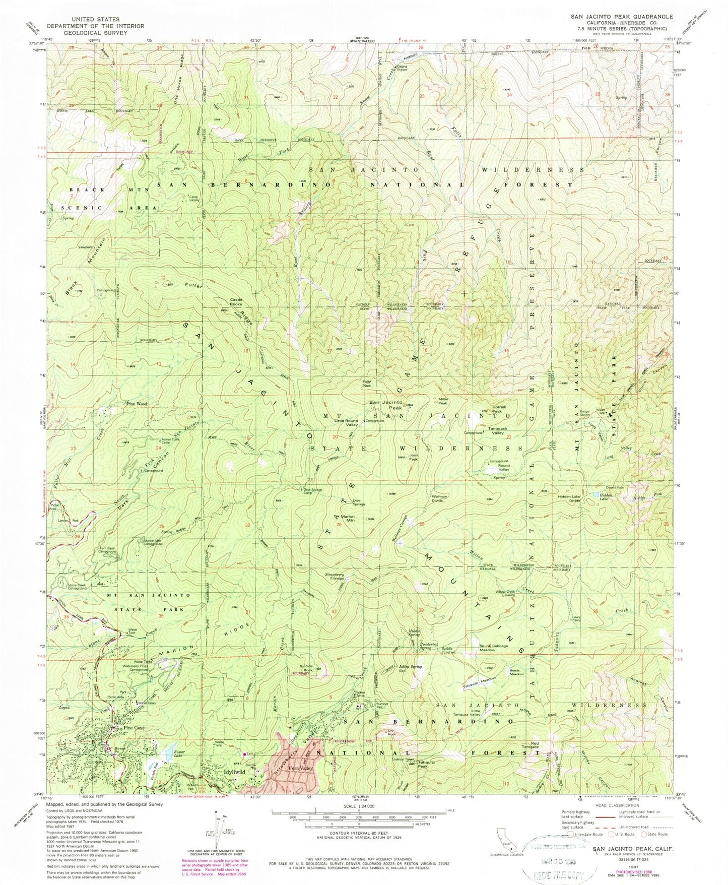
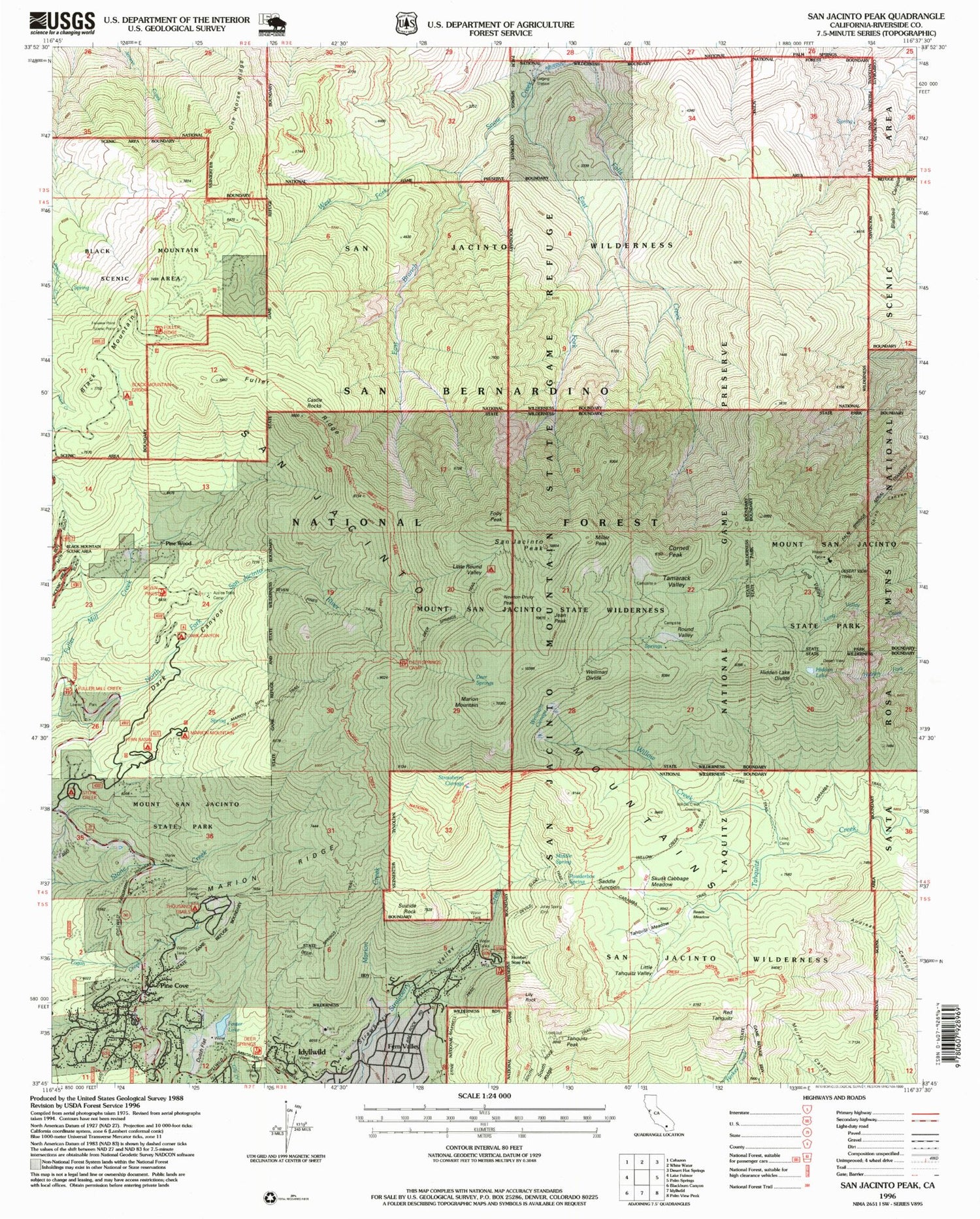
USGS Classic San Jacinto Peak California 7.5'x7.5' Topo Map
Couldn't load pickup availability
Historical USGS topographic quad map of San Jacinto Peak in the state of California. Scale: 1:24000. Print size: 24" x 27"
This quadrangle is in the following counties: Riverside.
The map contains contour lines, roads, rivers, towns, lakes, and grids including latitude / longitude and UTM / MGRS. Printed on high-quality waterproof paper with UV fade-resistant inks.
Contains the following named places: Black Mountain Camp, Cornell Peak, Dark Canyon Camp, Deer Springs, East Branch Snow Creek, East Fork Snow Creek, Falls Creek, Fern Basin Campground, Foster Lake, Fuller Mill Creek, Fuller Mill Creek Camp, Fuller Ridge, Hidden Lake, Hidden Lake Divide, Humber Park, Jolley Spring, Laws Camp, Little Round Valley, Little Tahquitz Valley, Long Valley, Marion Creek, Marion Mountain Campground, Marion Ridge, Middle Spring, Mount San Jacinto State Park, Pine Cove, Pine Flat Camp, Powderbox Spring, Camp Azalea Trails, Camp Lackey, Round Valley, San Jacinto Peak, Skunk Cabbage Meadow, Strawberry Cienaga, Suicide Rock, Tahquitz Meadow, Tamarack Valley, Wellman Divide, Wellmans Cienaga, West Fork Snow Creek, Willow Creek, Newton Drury Peak, Dark Canyon, One Horse Ridge, Black Mountain, South Ridge, Black Mountain Group Campground, Dark Canyon Campground, Fullermill Creek Campsite, Fairview Point Scenic Viewpoint, Tahquitz Peak Lookout, San Jacinto Mountains, Desert View, Fern Valley, Folly Peak, Jean Peak, Lily Rock, Marion Mountain, Miller Peak, Pine Wood, Red Tahquitz, Saddle Junction, Tahquitz Peak, Willow Creek Crossing, KATY-FM (Idyllwild), Foster 827 Dam, Castle Rocks, Deer Springs, Deer Springs Camp, Dutch Flat, Lawler Park, Reeds Meadow, Stone Creek Campground, Wilderness Pines Campground, Chinquapin Flat, Evergreen Campground, Fuller Mill Creek Picnic Area, Fuller RIdge Campground, Idyllwild Branch Riverside City and County Public Library, Little Round Valley Campground, Long Valley Picnic Area, Pine Cove County Park, Round Valley Campground, Riverside County Fire Department Station 23 Pine Cove, Hidden Divide Natural Preserve, Mount San Jacinto State Wilderness, Fuller Mill Creek Wild and Scenic River