MyTopo
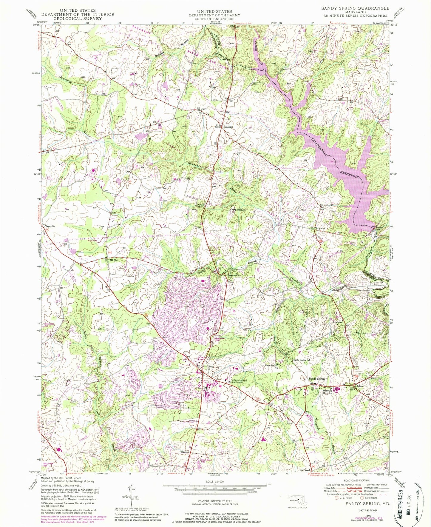
Classic USGS Sandy Spring Maryland 7.5'x7.5' Topo Map
Couldn't load pickup availability
Historical USGS topographic quad map of Sandy Spring in the state of Maryland. Typical map scale is 1:24,000, but may vary for certain years, if available. Print size: 24" x 27"
This quadrangle is in the following counties: Howard, Montgomery.
The map contains contour lines, roads, rivers, towns, and lakes. Printed on high-quality waterproof paper with UV fade-resistant inks, and shipped rolled.
Contains the following named places: Ashton, Brighton Dam, Camp Bennett, Cattail Creek, Haights Branch, James Creek, Reddy Branch, Sandy Spring, Sherwood High School, Slade School, Sunshine, Triadelphia Reservoir, Williamsburg Run, Brinklow, Claysville, Hawlings River, Brighton, Brookeville, Mount Zion, Norwood, Oakdale, Olney, Norbeck Golf Course, Fire Station Company 4, Fire Station Company 40, Olney Theater, Ashton First Baptist Church, Bnai Shalom Synagogue, Marian Fathers Novititate, Mount Carmel Church, Refuge Church of Christ, Saint Johns Episcopal Church, Salem United Methodist Church, Oakdale Emory United Methodist Church, Saint Peters Catholic Church, Sandy Spring Friends Meeting House Church, Sharp Street United Methodist Church, Montgomery Community Church, Olney Baptist Church, Olney Church of Christ, Oaks Landfill, Sandy Spring Community Center, Salem United Methodist Church Cemetery, Saint Lukes Episcopal Church Cemetery, Saint John's Episcopal Cemetery, Olney Library, Brooke Grove Health Center, Sherwood Library, Sandy Spring Elementary School (historical), Unity, Brighton Dam, Waredaca Farm Airport (historical), Federal Support Center Heliport, Brinklow Post Office (historical), Brookeville Post Office, Olney Post Office, Sandy Spring Post Office, Ashton Post Office, Medstar Montgomery Medical Center, Friends House Nursing Home, Sharon Nursing Home, Triadelphia (historical), Kalmia Farms, Karinwood, Triadelphia (historical), Triadelphia Mill Farms, Belmont Elementary School, Bowie Mill Estates, Bowie Mill Park, Bowie Mill Park, Briars Acres, Brighton Estates, Brighton Knolls, Brook Manor Park, Brooke Grove Elementary School, Brookemanor Estates, Brookeville Heights, Brookeville Knolls, Camelback Village, Cashell Elementary School, Cashell Manor, Cashell Road Park, Cashell Woods, Cherry Valley, Cherrywood, Colonel Zadok Magruder High School, Dellabrooke Estates, Denit Estates, Dobridge, Ednor Woods, Elton Cemetery, Flintridge, Granby Woods, Greenwood Elementary School, Greenwood Park, Griffith Park, Griffith Park, Hallowell, Hawlings Hills, Hawlings River Estates, Hawlings River Regional Park, Hawlings View, Highlands of Olney, Holiday Hills, Anscroft, Ashley Manor, Ashton Manor, Ashton River Estates, Longwood Park, Longwood Recreation Center, Mount Zion Park, Muncaster Manor, Muncaster Manor Park, Norbeck Estates, Norbrook Village, Olney Acres, Olney Elementary School, Olney Estates, Olney Mill, Olney Oaks, Olney Shopping Center, Olney Square, Olney Square Park, Olney Town, Quail Hill, Rachel Carson Conservation Park, Reedy Branch Park, Rolling Knolls, Saint Lukes Episcopal Church, Sam Rice Manor, Sandy Spring Friends School, Sandy Spring Meadow, Sequoyah Elementary School, Sharp Street School (historical), Sherwood Elementary School, Southeast Olney Park, Sunnymeade, Sunshine Acres, Tanterra, Timberland Estates, Towne Centre Place, Willett Estates, William H Farquhar Middle School, Williamsburg Village, Woodlawn Park, Fairhill, Hawlings Meadow, Avenel, District 8, Rosa M Parks Middle School, Olney Library, Sandy Spring Volunteer Fire Department - Station 40, Sandy Spring Volunteer Fire Department - Station 4, Olney Adventist Preparatory School, Saint Peter's Elementary School, Julia Brown Montessori School - Olney Campus, Community School of Maryland - Brookeville Campus, Saint John's Episcopal School, Ashton-Sandy Spring Census Designated Place, Olney Census Designated Place, Town of Brookeville, Lutheran Church of the Good Shepherd, Faith Presbyterian Church of Olney, Hampshire View Baptist Church, Trotters Glen Golf Course, Blue Mash Golf Course, Olney Seventh Day Adventist Church, Abrams, Ashton Preserve, Brooke Meadow, Ednor Highlands, Gold Mine Crossing, Manor Oaks, Twist and Turn Estates, Bnai Shalom of Olney Nursery School, Brooke Grove Rehabilitation and Nursing Center, Hampshire Greens Golf Course, Marian Assisted Living Center, The Meadows Assisted Living Center, Park Overlook Farm, Laytonsville Turf Farm, Norwood Post Office (historical), Ashton, Brighton Dam, Camp Bennett, Cattail Creek, Haights Branch, James Creek, Reddy Branch, Sandy Spring, Sherwood High School, Slade School, Sunshine, Triadelphia Reservoir, Williamsburg Run, Brinklow, Claysville, Hawlings River, Brighton, Brookeville, Mount Zion, Norwood, Oakdale, Olney, Norbeck Golf Course, Fire Station Company 4, Fire Station Company 40, Olney Theater, Ashton First Baptist Church, Bnai Shalom Synagogue, Marian Fathers Novititate, Mount Carmel Church, Refuge Church of Christ, Saint Johns Episcopal Church, Salem United Methodist Church, Oakdale Emory United Methodist Church, Saint Peters Catholic Church, Sandy Spring Friends Meeting House Church, Sharp Street United Methodist Church, Montgomery Community Church, Olney Baptist Church, Olney Church of Christ, Oaks Landfill, Sandy Spring Community Center, Salem United Methodist Church Cemetery, Saint Lukes Episcopal Church Cemetery, Saint John's Episcopal Cemetery, Olney Library, Brooke Grove Health Center, Sherwood Library, Sandy Spring Elementary School (historical), Unity, Brighton Dam, Waredaca Farm Airport (historical), Federal Support Center Heliport, Brinklow Post Office (historical)