MyTopo
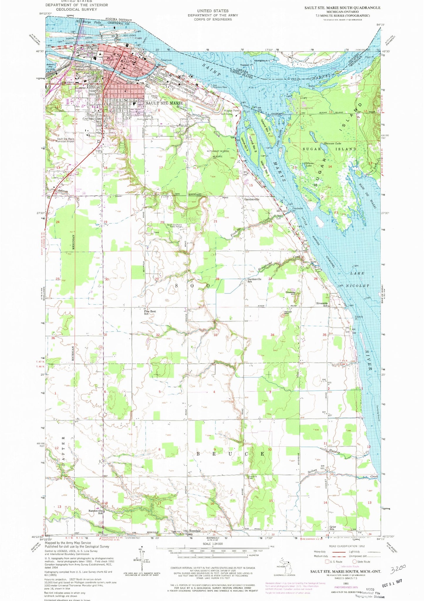
Classic USGS Sault Ste. Marie South Michigan 7.5'x7.5' Topo Map
Couldn't load pickup availability
Historical USGS topographic quad map of Sault Ste. Marie South in the state of Michigan. Map scale may vary for some years, but is generally around 1:24,000. Print size is approximately 24" x 27"
This quadrangle is in the following counties: Chippewa.
The map contains contour lines, roads, rivers, towns, and lakes. Printed on high-quality waterproof paper with UV fade-resistant inks, and shipped rolled.
Contains the following named places: Administration Building, Alford Park, Apostolic Lutheran Church, Arts Center, Ashmun Creek, Aune Osborn Park, Baie de Wasai, Bayfield Rock Range Lights, Bayliss Public Library, Beaver Dam Creek, Black Point, Brady Hall, Brown Hall, Calvary Baptist Church, Campus Shoppe, Cass Point, Central Heating Plant, Central Methodist Church Historical Marker, Central United Methodist Church, Child Development Center, Child Evangelism Fellowship, Chippewa County Courthouse, Chippewa County Sheriff's Office, Chippewa House, Chippewa Travel Trailer Park, Church of Christ, Church of the Nazarene, City of Sault Ste. Marie, Coast Guard Station Sault Saint Marie, Community Baptist Church, Cook Island, Crawford Hall of Science, East Hall, Easterday House, Edison Sault Electric Company Canal, Edna M Youngs Student Health Center, Elmwood Historical Marker, Erie Hall, Ermatinger Creek, Faith Baptist Church, Faith Lutheran Church, First Baptist Church, First Church of Christ, Fletcher Center, Fornicola Trailer Park, Frechette Creek, Frechette Point, Free Methodist Church, Gardenville, Gardenville School, Gate House, Great Lakes Fleet Marine Railway, Grier School, Hillside House, His House Christian Fellowship, Hog Island, Huron Hall, Hursley Creek, Immanuel Lutheran School, Iroquois House, Island Number Four, Island Number One, Island Number Three, Island Number Two, James Norris Physical Education Center, John Johnston House, John Johnston House Historical Marker, Kenneth J Shouldice Library, Kewadin Park, Kingdom Hall of Jehovah's Witnesses, Lake Superior Estates, Lake Superior State College Historical Marker, Lake Superior State University, Laker Hall, Lakeview Internal Medicine, Larke Road Historical Marker, Lawrences Marina, Leno A Pianosi Maintenance Center, Lincoln Elementary School, Little Rapids, Lukenda Alumni House, Malcolm High School, Malcolm Park, Maple Ridge Cemetery, Marchand Rock, Marquette Hall, Marquette Specialty Clinic, Methodist Indian Mission Historical Marker, Methodist Mission Reserve, Michigan Department of Natural Resources Sault Sainte Marie Field Office, Michigan State Police District 8 Sault Sainte Marie Post 82, Minneapolis Woods, Mission Creek, Mission Point, Moloney Hall, Mount Hope Church, Museum Ship Valley Camp, Neveu Hall, New Fort Brady Historical Marker, Newman Center, Northern Michigan Hospital, Oldman Lake, Oneway Hill, Ontario Hall, Open Door Baptist Church, Osborn Hall, Pine Rest School, Presbyterian Church, President's Residence, Ransonville School, River of History Museum, Riverside Cemetery, Riverside Mobile Home Village, Riverside School, Robert Arbuckle Student Activity Center, Rosedale, Rosedale Airport, Rosedale Cemetery, Rosedale Community Church, Rosedale Post Office, Rotary Island, Rotary Park, Ryan House, Sailors Creek, Saint Barnabas Lutheran Church, Saint George Greek Orthodox Church, Saint Isaac Jogues Catholic Church, Saint James Episcopal Church, Saint Joseph Church, Saint Mary's Church, Saint Mary's Elementary School, Saint Mary's Medical Center, Saint Mary's Pro-Cathedral Historical Marker, Sainte Marie Yard and Marine, Sault Area High School and Career Center, Sault Area Middle School, Sault Boat Club, Sault Internal Medicine, Sault Sainte Marie, Sault Sainte Marie Fire Department, Sault Sainte Marie Municipal Boat Harbor Ramp, Sault Sainte Marie Police Department, Sault Sainte Marie Post Office, Sault Sainte Marie Welcome Center, Sault Ste Marie Golf Course, Sault Ste Marie Living Word Church, Sault Ste Marie Municipal Airport/Sanderson Field, Sault Ste Marie Station, Sault Ste Marie Wesleyan Church, Sault Tribe Law Enforcement - Police Department, Shawnee Lake, Sixmile Point, Soo Locks Campground, Soo Plaza Shopping Center, Soo Seaplane Base, Soo Township Elementary School, South Hall, Steers Island, Sugar Islander Ferry, Tendercare Nursing Home, The Village, Tower of History, Twin City Drydock and Marine, United States Coast Guard Yards and Docks, United States Forest Service Hiawatha National Forest, United States Steel Corporation, Upper Nicolet Range, Upper Peninsula School, Velvet Hill, Vocational-Technical Center, Walker Cisler Center, War Memorial Hospital, Washington Elementary School, Welchs Dock, WKNW-AM (Sault Sainte Marie), ZIP Code: 49783


