MyTopo
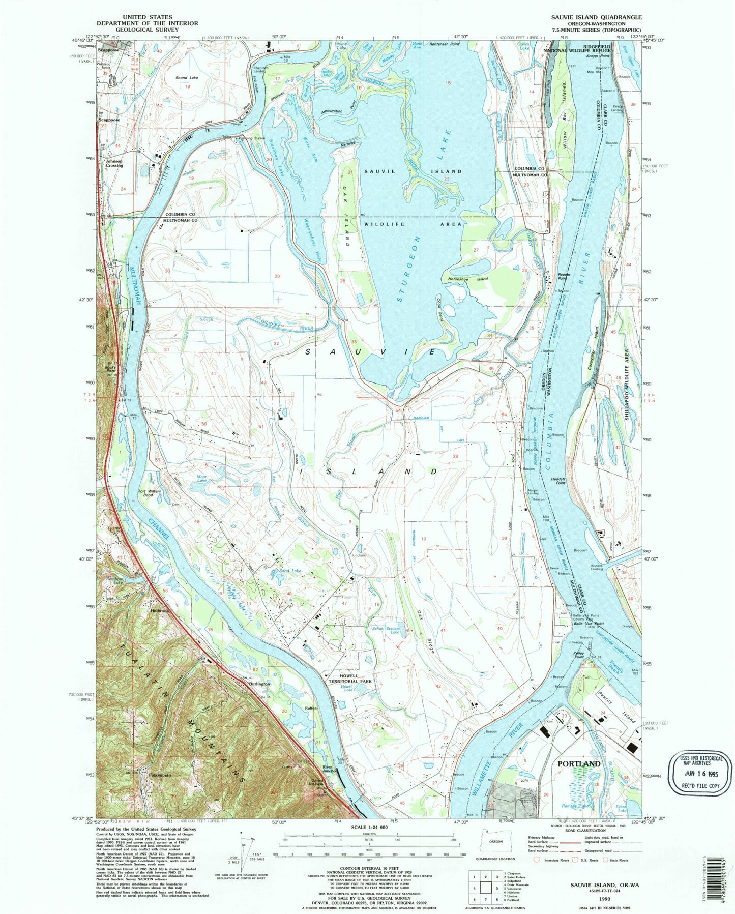
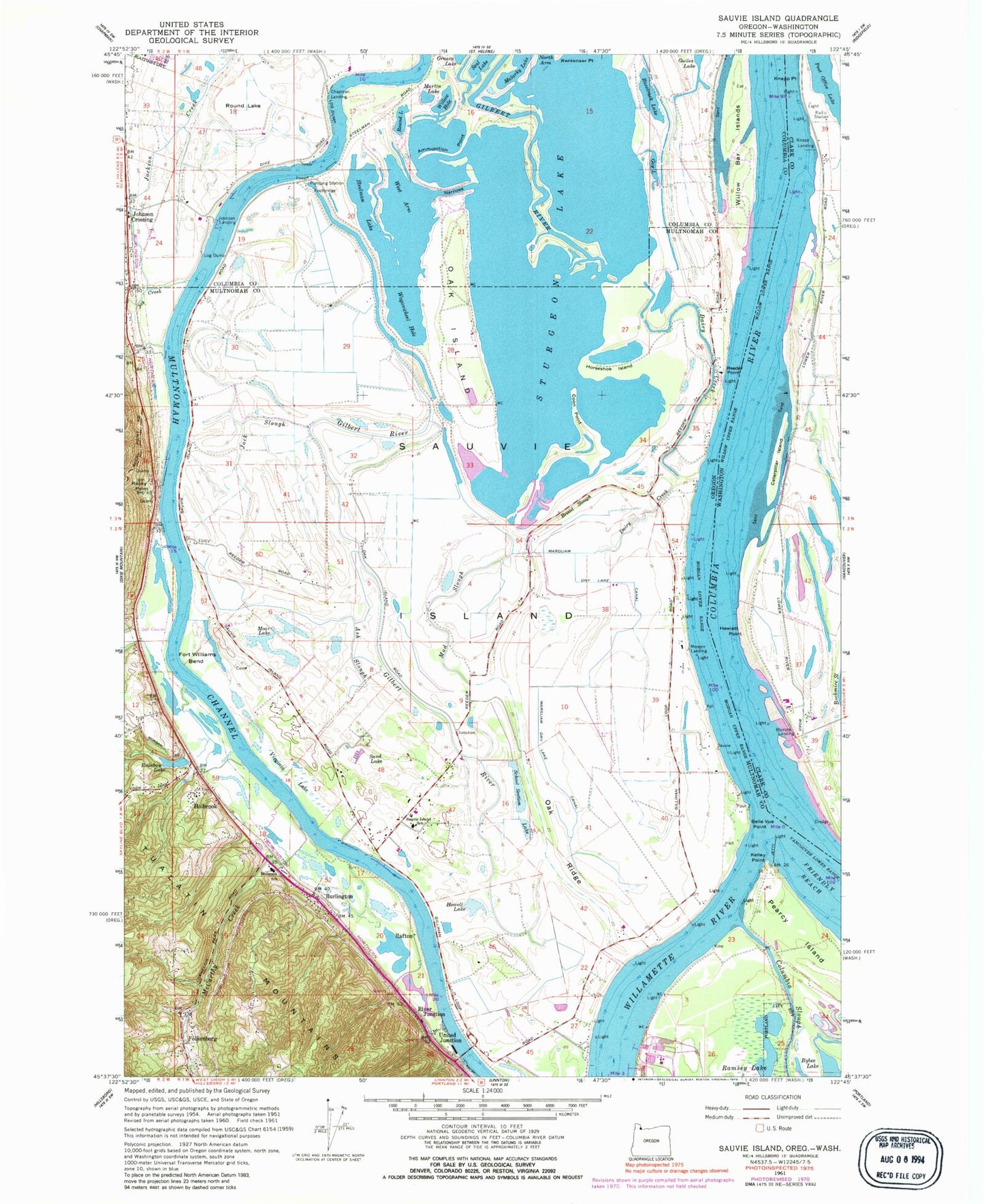
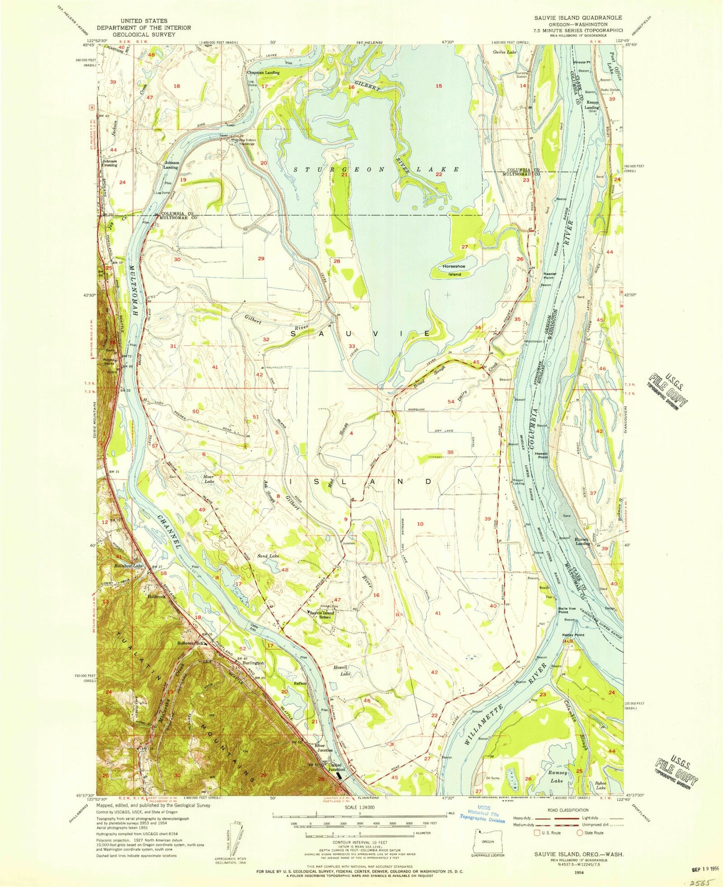
Classic USGS Sauvie Island Oregon 7.5'x7.5' Topo Map
Couldn't load pickup availability
Historical USGS topographic quad map of Sauvie Island in the states of Oregon, Washington. Typical map scale is 1:24,000, but may vary for certain years, if available. Print size: 24" x 27"
This quadrangle is in the following counties: Clark, Columbia, Multnomah.
The map contains contour lines, roads, rivers, towns, and lakes. Printed on high-quality waterproof paper with UV fade-resistant inks, and shipped rolled.
Contains the following named places: Ammunition Point, Ash Slough, Belle Vue Point, Broad Slough, Burlington, Chapman Landing, Coon Point, Dairy Creek, Fort William Bend, Holbrook School (historical), Howell Lake, Jack Slough, Johnson Landing, Jones Creek, Joy Creek, Kelley Point, Malarky Lake, Marquam Dry Lake Canal, Martin Lake, McCarthy Creek, Moar Lake, Morgan Landing, Morgan Lower Range, Morgan Upper Range, Mud Slough, Multnomah Channel, Narrows, Oak Island, Oak Ridge, Pearcy Island, Racetrack Lake, Rainbow Lake, Ramsey Lake, Reeder Point, Sand Lake, Sauvie Island, Sauvie Island School, School Section Lake, Seal Lake, Steelman Lake, Sturgeon Lake, Vancouver Lower Channel, Virginia Lake, Wagonwheel Hole, West Arm, Willow Bar Islands, Willow Hole, Arthur (historical), Haldeman Pond, Marquam Lake, Ramsey Island (historical), Rocky Point, Morgan Turn, Holbrook, Rafton (historical), River Junction, Willow Lower Range, Morgan Channel, Willamette River, Columbia Slough, Horseshoe Island, Round Lake, Willow Upper Range, Moar Cemetery, Wildwood Golf Course, Gay Lake, Post Office Bar (historical), Riverview (historical), Ban (historical), Sauvies (historical), Sauvies Island Post Office (historical), Sauvies Post Office (historical), Willamette Slough Post Office (historical), Arthur Post Office (historical), Holbrook Post Office (historical), Gilmore Lake Landing, Lake Farm Landing, Stumps Landing, Oak Island Landing, Frakes Landing, Dry Lake, Sand Island (historical), Griffith Island (historical), Little Sturgeon Lake, Belle Vue Point Park, Howell Territorial Park, The Wash, Mud Lake, Holman Point, Johnson Lake, Kelley Point City Park, Multnomah Channel County Park, Harbor Track (historical), Hubluco (historical), Brix (historical), Morgan Upper Range, Lucerne (historical), Albeto (historical), Ban Spur (historical), Folkenberg, United Junction, Sauvie Island Game Management Area, Sauvie Island Bridge, Mouse Island Lake (historical), Skyline Division, Fort William (historical), Sauvie Island Boat Ramp, Scappoose High School, Sauvie Island Community Church, Holbrook Bible Church, Scappoose Rural Fire Protection District Marina, Sauvie Island Fire Department, Native American Rehabilitation Association of the Northwest Treatment Center, Vetsch Dairy Farm, Scappoose Moorage, McCuddy's / Browns Landing Marina Boat Launch, McCuddy's / Browns Landing Marina, McIntyre Landing, Reeder Point Post Light, Casselman's Wharf, Happy Rock Moorage, Happy Rock Moorage, Sturgeon Lake Access Ramp, Rock Point Marina, McCuddy's Big Oak Marina, Hadley's Landing \ Wapato Dock, McCuddy's Big Oak Marina, Sauvie Island Moorage, Rivers Bend Marina, Caterpillar Island, Hewlett Point, Knapp Point, Post Office Lake, Vancouver Lower Range, Willow Lower Range, Willow Upper Range, Shillapoo Wildlife Recreation Area, Blurock Landing, Knapp Landing, Morgan Turn, Ammunition Point, Ash Slough, Belle Vue Point, Broad Slough, Burlington, Chapman Landing, Coon Point, Dairy Creek, Fort William Bend, Holbrook School (historical), Howell Lake, Jack Slough, Johnson Landing, Jones Creek, Joy Creek, Kelley Point, Malarky Lake, Marquam Dry Lake Canal, Martin Lake, McCarthy Creek, Moar Lake, Morgan Landing, Morgan Lower Range, Morgan Upper Range, Mud Slough, Multnomah Channel, Narrows, Oak Island, Oak Ridge, Pearcy Island, Racetrack Lake, Rainbow Lake, Ramsey Lake, Reeder Point, Sand Lake, Sauvie Island, Sauvie Island School, School Section Lake, Seal Lake, Steelman Lake, Sturgeon Lake, Vancouver Lower Channel, Virginia Lake, Wagonwheel Hole, West Arm, Willow Bar Islands, Willow Hole, Arthur (historical), Haldeman Pond, Marquam Lake, Ramsey Island (historical), Rocky Point, Morgan Turn, Holbrook, Rafton (historical), River Junction, Willow Lower Range, Morgan Channel, Willamette River, Columbia Slough, Horseshoe Island, Round Lake, Willow Upper Range, Moar Cemetery, Wildwood Golf Course, Gay Lake, Post Office Bar (historical), Riverview (historical), Ban (historical), Sauvies (historical), Sauvies Island Post Office (historical), Sauvies Post Office (historical), Willamette Slough Post Office (historical), Arthur Post Office (historical), Holbrook Post Office (historical), Gilmore Lake Landing, Lake Farm Landing, Stumps Landing, Oak Island Landing, Frakes Landing, Dry Lake, Sand Island (historical), Griffith Island (historical), Little Sturgeon Lake, Belle Vue Point Park, Howell Territorial Park, The Wash, Mud Lake, Holman Point, Johnson Lake, Kelley Point City Park, Multnomah Channel County Park, Harbor Track (historical), Hubluco (historical), Brix (historical), Morgan Upper Range