MyTopo
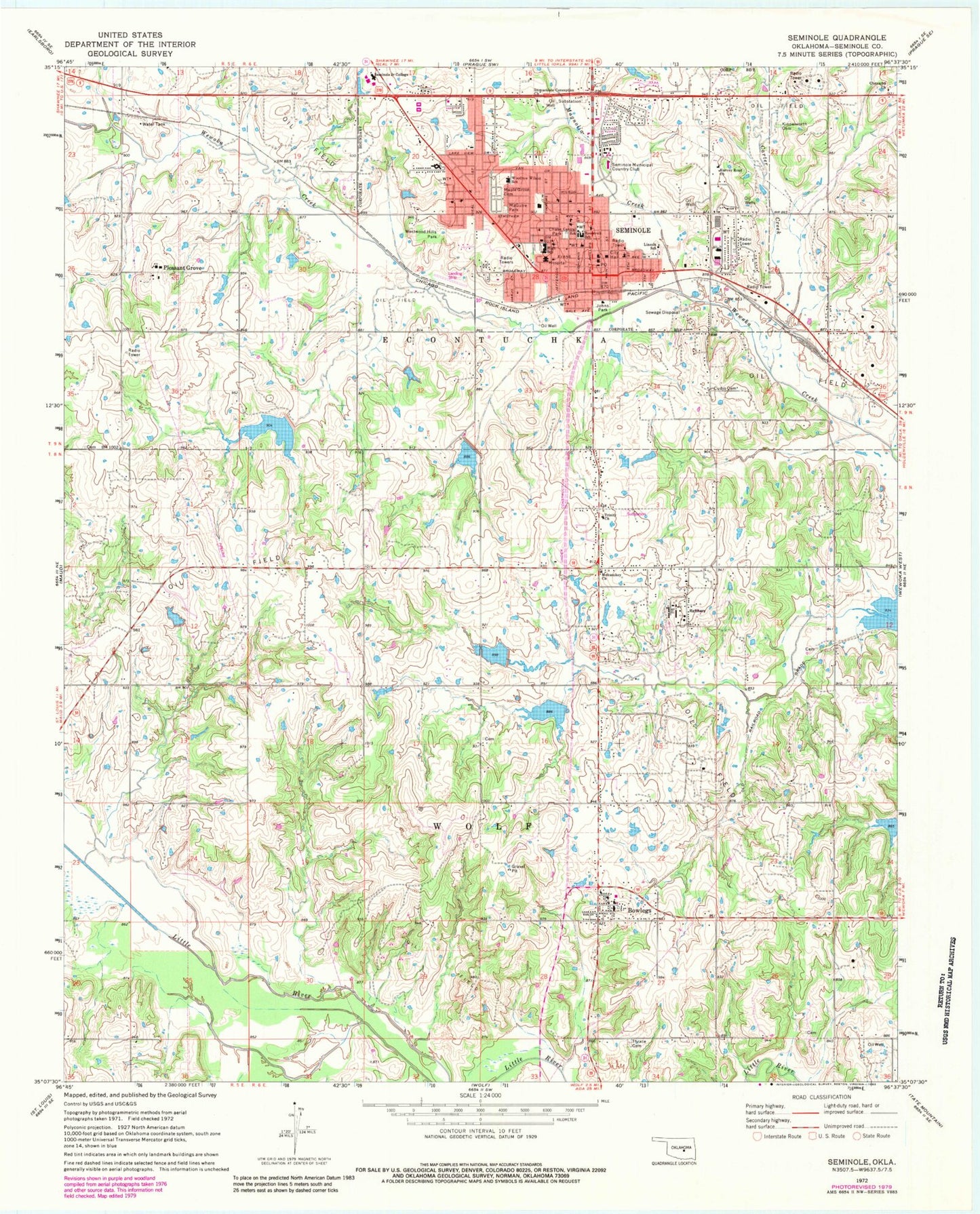
Classic USGS Seminole Oklahoma 7.5'x7.5' Topo Map
Couldn't load pickup availability
Historical USGS topographic quad map of Seminole in the state of Oklahoma. Map scale may vary for some years, but is generally around 1:24,000. Print size is approximately 24" x 27"
This quadrangle is in the following counties: Seminole.
The map contains contour lines, roads, rivers, towns, and lakes. Printed on high-quality waterproof paper with UV fade-resistant inks, and shipped rolled.
Contains the following named places: Alliance Health Seminole Medical Center, Big Wewoka Creek Site 12 Dam, Big Wewoka Creek Site 12 Reservoir, Big Wewoka Creek Site 4 Dam, Big Wewoka Creek Site 4 Reservoir, Big Wewoka Creek Site 6 Dam, Big Wewoka Creek Site 6 Reservoir, Big Wewoka Creek Site 7 Dam, Big Wewoka Creek Site 7 Reservoir, Big Wewoka Creek Site 8 Dam, Big Wewoka Creek Site 8 Reservoir, Bowlegs, Bowlegs Elementary School, Bowlegs High School, Bowlegs Post Office, Bowlegs Volunteer Fire Department, Carter Creek, Central School, Chase Park, Cheyarha Church, Church of the Nazarene, City of Seminole, Cudjo Cemetery, First Assembly of God Church, First Baptist Church, First Christian Church, First Penecostal Holiness Church, Free Will Baptist Church, Harvey Road Church, Immaculate Conception Church, Immanuel Fellowship, Johns Park, Kinnelworth Cemetery, KSLE-FM (Seminole), Lincoln School, Magnolia Creek, MaGuire Park, Maple Grove Cemetery, Mekusukey Church, Northwood Elementary School, Oknoname 133002 Dam, Oknoname 133002 Reservoir, Pleasant Grove, Pleasant Grove Elementary School, Roosevelt School, Seminole, Seminole Center, Seminole City Jail, Seminole Fire Department Station 1, Seminole Fire Department Station 2, Seminole Junior - Senior High School, Seminole Middle School, Seminole Municipal Country Club, Seminole Nation and Veterans Memorial Cemetery, Seminole Nation Lighthorse Police Department, Seminole Oklahoma Tribal Statistical Area, Seminole Police Department, Seminole Post Office, Seminole Shopping Center, Seminole State College, Seminole State College Police Department, Strother Elementary School, Strother High School, Temple of Praise PCG, The Church of Jesus Christ of Latter Day Saints, Thrace Cemetery, Town of Bowlegs, Trinity Church, Westwood Hills Park, Woodrow Wilson Elementary School, Woodrow Wilson School, Zevely Climbing ZZ Ranch Airport, ZIP Code: 74830