
MyTopo
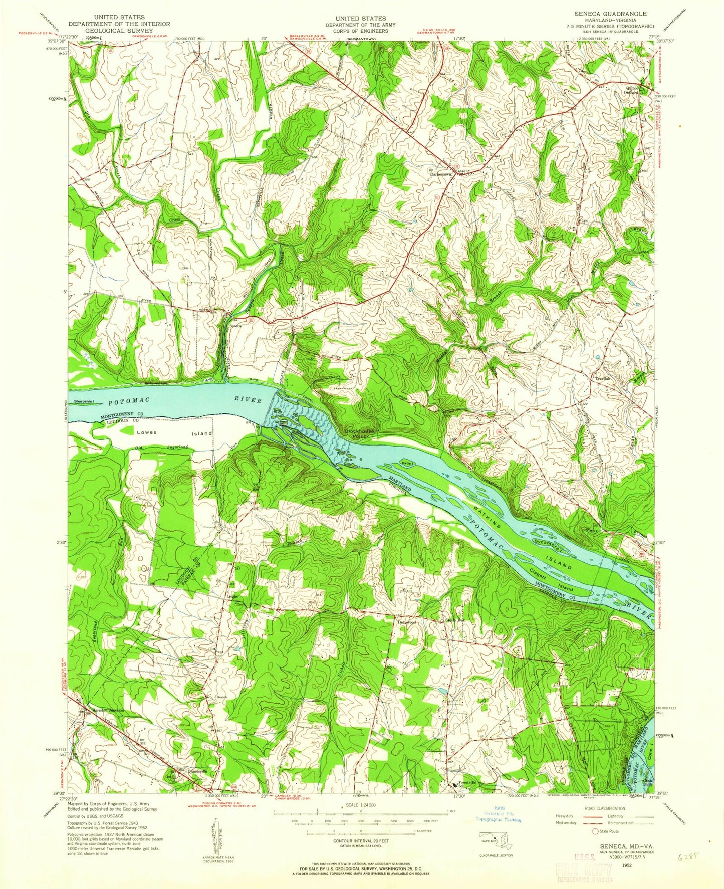
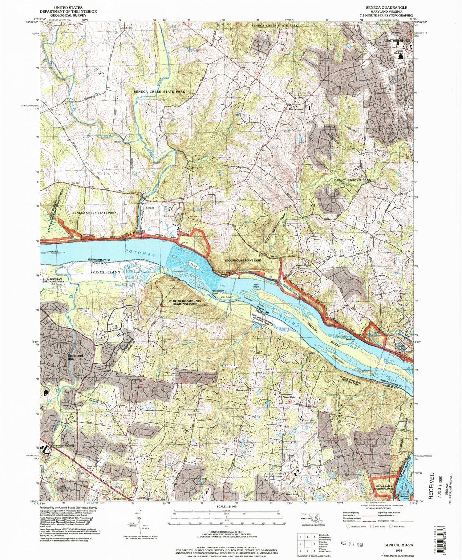
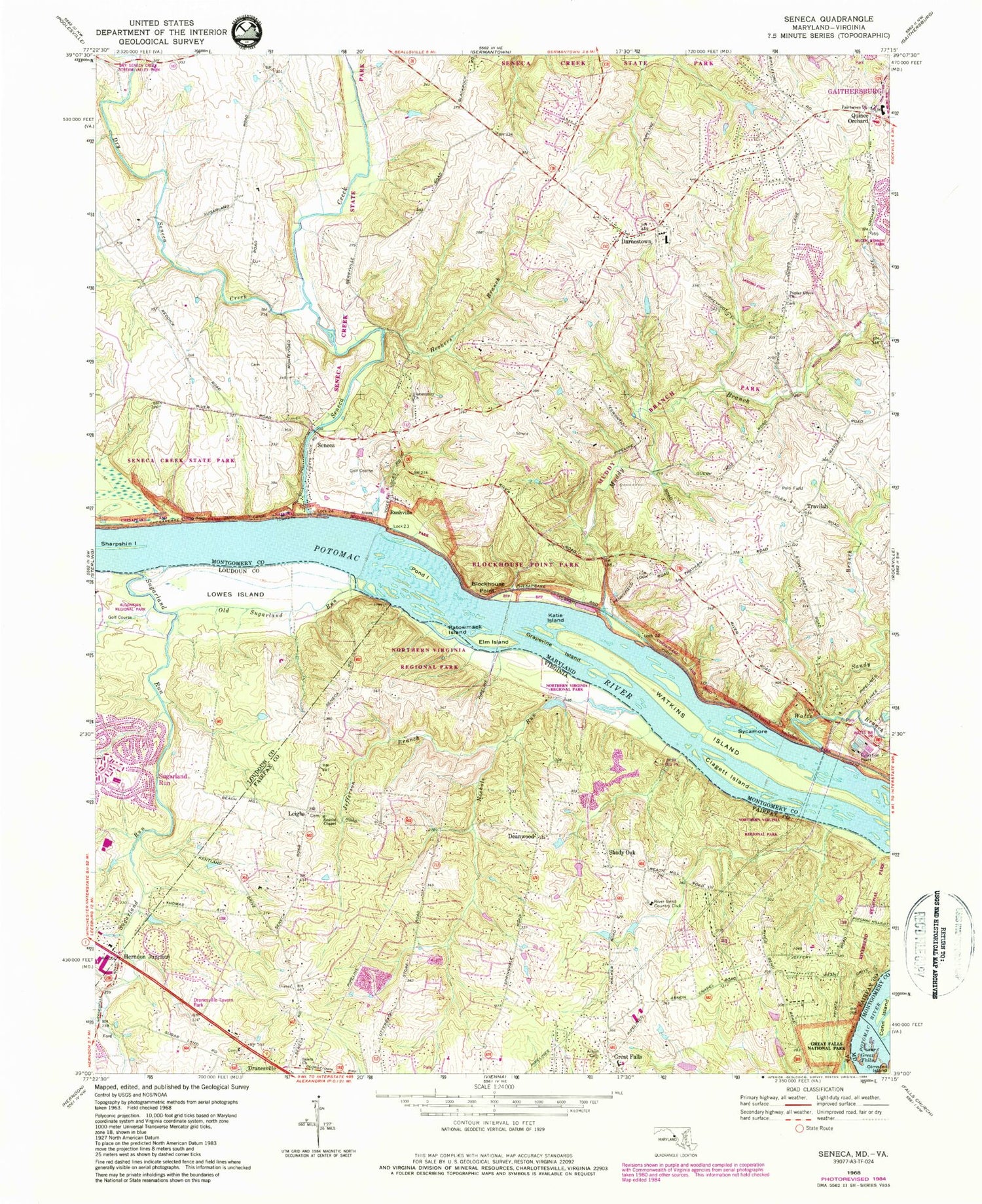
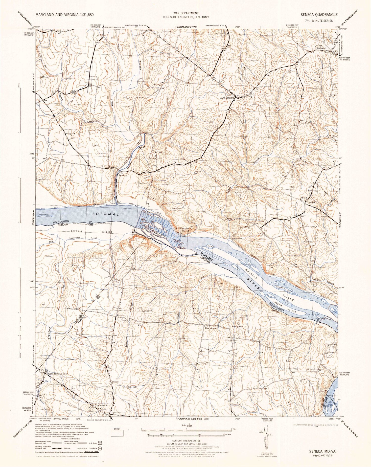
Classic USGS Seneca Maryland 7.5'x7.5' Topo Map
Couldn't load pickup availability
Historical USGS topographic quad map of Seneca in the states of Maryland, Virginia. Typical map scale is 1:24,000, but may vary for certain years, if available. Print size: 24" x 27"
This quadrangle is in the following counties: Fairfax, Loudoun, Montgomery.
The map contains contour lines, roads, rivers, towns, and lakes. Printed on high-quality waterproof paper with UV fade-resistant inks, and shipped rolled.
Contains the following named places: Blockhouse Point, Clagett Island, Dry Seneca Creek, Elm Island, Fairhaven Church, Grapevine Island, Great Falls, Greenbrier Branch, Hookers Branch, Katie Island, Muddy Branch, Pond Island, Russell Branch, Sandy Branch, Seneca, Seneca Creek, Sharpshin Island, Sycamore Island, Watkins Island, Watts Branch, Cliff Bland Recreation Area, Quince Orchard, Rushville, Travilah, Darnestown, WSSC Filtration Plant, Darnestown United Presbyterian Church, Fairhaven United Methodist Church, Bretton Woods Golf Course, Darnestown Presbyterian Church Cemetery, Rockville Volunteer Fire Department - Station 31, Poplar Grove Baptist Church, Herron Spring, Beallmount, Blockhouse Point Park, Bretton Woods Recreation Center, Brookmead, Brookmead North, Browns Corner, Community Church, Deakins Range, Dierssen Waterfowl Sanctuary, Dry Seneca Creek Stream Valley Park, Estates at Rivers Edge, Esworthy Estates, Esworthy Park, Farmlands, Harlow, Harris Island, Haywire Farm, Lock 22, Lock 23, Lock 24, Pioneer Hills, Potomac Park Estate, Ridgeland Farm Estates, Rive Gauche Estates, Riverwood, Rockville Water Treatment Plant, Rowsers Ford, Seneca Breaks, Seneca Creek Aqueduct, Seneca Creek State Park, Seneca Highlands, Seneca Quarry, Spring Meadows, Tobytown, Tobytown Park, Woodbyran Farms, Aberdeen Park, Ancient Oak, Ancient Oak North, Ancient Oak West, Andrew Small Male and Female Academy (historical), Belvedere, Bondbrook, Darnestown Elementary School, Darnestown Hills, Darnestown Knolls, Fox Hills North, Glen Query, Hartley Hall Estates, Harvest Hunt Farm, Highlands of Darnestown, Fox Hills Green, Jones Lane Elementary School, Lake Potomac, Mills Farm, Mills Farm East, Mitchells Range, Mountain View Estates, Orchard Park, North Potomac, Polo Club Estates, Potomac Chase, Potomac Chase Estates, Potomac Grove, Potomac Valley Shopping Center, Quail Run, Quince Orchard High School, Quince Orchard Knolls, Stoney Creek Estates, Stoney Creek Farm, Travilah Acres, Travilah Meadows, Willow Ridge, Windmill Farm, District 6, Thurgood Marshall Elementary School, Quince Orchard Library, Butler School, The Circle School, Mary of Nazareth Elementary School, Darnestown Census Designated Place, Gaithersburg Chinese Alliance Church, Homestead Farm, Arnon Chapel Cemetery, Dranesville, Jefferson Branch, Lowes Island, Nichols Run, Old Sugarland Run, Patowmack Island, Riverview Park, Shady Oak, Sugarland Run, Muddy Branch, River Bend Country Club, Smith's Chapel United Methodist Cemetery, Dranesville Methodist Church, Calvary Baptist Church, House of God Church, Riverbend Nature Center, Seneca Ridge Middle School, Potomac Baptist Church, Salem Baptist Church, Smiths Chapel Methodist Church, Deanwood, Herndon Junction, Leighs, Meadowland Elementary School, Town Center at Sterling, Dranesville Tavern, Dranesville Tavern Park, Great Falls Elementary School, Holly Knoll Park, Riverbend Regional Park, Lowes Island, Sugarland Run District, Potomac Heritage Trail, Meadow Trail, Paw Paw Passage Trail, Lowes Island Elementary School, Dominion High School, Quarterpath Trace Community Center, Lowes Island Community Center, Estates Community Center, Great Falls Census Designated Place, Lowes Island Census Designated Place, Dranesville United Methodist Church Cemetery, Ford - Ellis - Simms Cemetery, Great Falls Plaza, Blockhouse Point, Clagett Island, Dry Seneca Creek, Elm Island, Fairhaven Church, Grapevine Island, Great Falls, Greenbrier Branch, Hookers Branch, Katie Island, Muddy Branch, Pond Island, Russell Branch, Sandy Branch, Seneca, Seneca Creek, Sharpshin Island, Sycamore Island, Watkins Island, Watts Branch, Cliff Bland Recreation Area, Quince Orchard, Rushville, Travilah, Darnestown, WSSC Filtration Plant, Darnestown United Presbyterian Church, Fairhaven United Methodist Church, Bretton Woods Golf Course, Darnestown Presbyterian Church Cemetery, Rockville Volunteer Fire Department - Station 31, Poplar Grove Baptist Church, Herron Spring, Beallmount, Blockhouse Point Park, Bretton Woods Recreation Center, Brookmead, Brookmead North, Browns Corner, Community Church, Deakins Range, Dierssen Waterfowl Sanctuary, Dry Seneca Creek Stream Valley Park, Estates at Rivers Edge, Esworthy Estates, Esworthy Park, Farmlands, Harlow, Harris Island, Haywire Farm, Lock 22, Lock 23, Lock 24, Pioneer Hills, Potomac Park Estate, Ridgeland Farm Estates, Rive Gauche Estates, Riverwood, Rockville Water Treatment Plant, Rowsers Ford, Seneca Breaks, Seneca Creek Aqueduct, Seneca Creek State Park, Seneca Highlands, Seneca Quarry, Spring Meadows, Tobytown, Tobytown Park, Woodbyran Farms, Aberdeen Park, Ancient Oak, Ancient Oak North, Ancient Oak West, Andrew Small Male and Female Academy (historical)