MyTopo
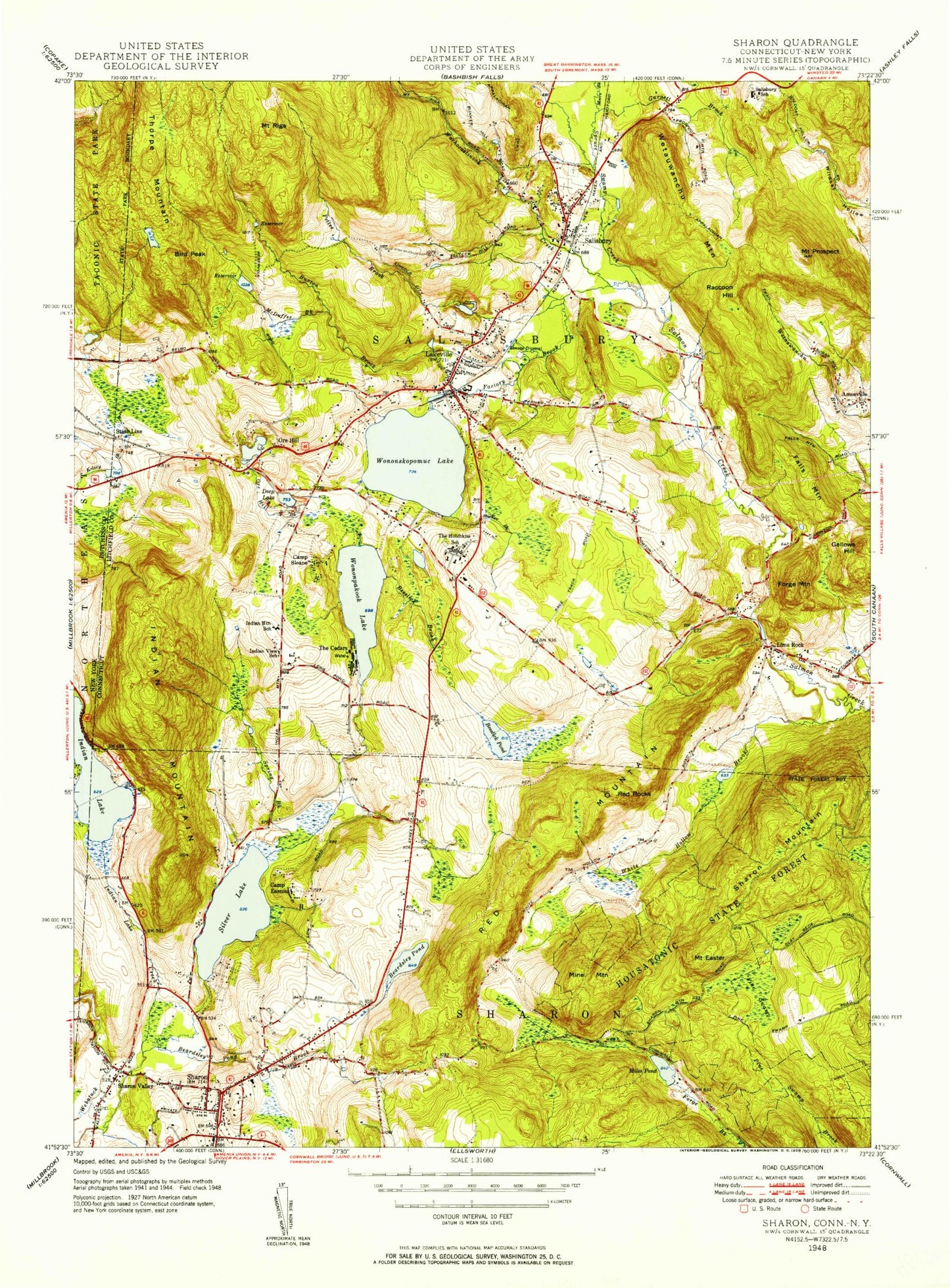
Classic USGS Sharon Connecticut 7.5'x7.5' Topo Map
Couldn't load pickup availability
Historical USGS topographic quad map of Sharon in the states of Connecticut, New York. Typical map scale is 1:24,000, but may vary for certain years, if available. Print size: 24" x 27"
This quadrangle is in the following counties: Dutchess, Litchfield.
The map contains contour lines, roads, rivers, towns, and lakes. Printed on high-quality waterproof paper with UV fade-resistant inks, and shipped rolled.
Contains the following named places: Wachocastinook Creek, Amesville, Bauer Pond, Beardsley Pond, Beardsley Pond Brook, Beeslick Brook, Beeslick Pond, Bird Peak, Burton Brook, Camp Easton, Camp Sloane, Deep Lake, Factory Brook, Falls Mountain, Forge Mountain, Gallows Hill, Garnett Brook, Indian Lake, Indian Mountain, Indian Mountain School, Kelsey Brook, Lakeville, Lime Rock, Lorenzo Pond, McDuffee Brook, Miles Pond, Mine Mountain, Moore Brook, Mount Easter, Mount Prospect, Mount Riga, Mudge Pond, Mudge Pond Brook, Ore Hill Brook, Ore Hill Pond, Pettee Brook, Pine Swamp, Raccoon Hill, Red Mountain, Red Rocks, Salisbury, Salisbury School, Sharon, Sharon Mountain, Sharon Valley, Spruce Swamp Creek, State Line, Sucker Brook, Tan Fat Hill, Taylor Pond, The Cedars, The Hotchkiss School, Thorpe Mountain, Wetauwanchu Mountain, White Hollow Brook, Wononpakook Lake, Wononskopomuc Lake, Ore Hill, Lakeville Reservoir Number 1, Lakeville Reservoir Number 2, Sharon Hospital Heliport, Town of Salisbury, Buckley Pond Dam, Buckley Pond, Lake Tayolan Dam, Lake Tavolan, Wononpakook Lake Dam, Miles Pond Dam, Lakeville Reservoir Number 2 Dam, Brook Hill, Bunker Hill, Cemetery Hill, Cobble Park, Congregational Church of Christ, Edsel Ford Memorial Library, Fink Hill, First Congregational Church, Gay Woods Hill, Gay-Holt House Museum, Holley Williams House Museum, Hotchkiss Library of Sharon, Interlaken Estates, King Hill, Lakeview United Methodist Church, Lakeview Post Office, Lime Rock Historic District, Lime Rock Park, Long Pond Brook, Medical Arts Building, Memorial Clock Tower, Miles Wildlife Sanctuary, Mudge Pond Town Beach, Mudgetown, Reed Hill, Sharon Valley Historic District, Lakeville Hose Company, Sharon Fire Marshal's Office, Salisbury Fire Marshal's Office, Sharon Fire Department Station 1, Lakeville Census Designated Place, Sharon Census Designated Place, Sharon Hospital, Salisbury Volunteer Ambulance Service, Lime Rock Park Ambulance, Trinity Church Lime Rock, Lakeville Post Office, Trinity Episcopal Cemetery, Town Hill Cemetery, State Line, Wachocastinook Creek, Amesville, Bauer Pond, Beardsley Pond, Beardsley Pond Brook, Beeslick Brook, Beeslick Pond, Bird Peak, Burton Brook, Camp Easton, Camp Sloane, Deep Lake, Factory Brook, Falls Mountain, Forge Mountain, Gallows Hill, Garnett Brook, Indian Lake, Indian Mountain, Indian Mountain School, Kelsey Brook, Lakeville, Lime Rock, Lorenzo Pond, McDuffee Brook, Miles Pond, Mine Mountain, Moore Brook, Mount Easter, Mount Prospect, Mount Riga, Mudge Pond, Mudge Pond Brook, Ore Hill Brook, Ore Hill Pond, Pettee Brook, Pine Swamp, Raccoon Hill, Red Mountain, Red Rocks, Salisbury, Salisbury School, Sharon, Sharon Mountain, Sharon Valley, Spruce Swamp Creek, State Line, Sucker Brook, Tan Fat Hill, Taylor Pond, The Cedars, The Hotchkiss School, Thorpe Mountain, Wetauwanchu Mountain, White Hollow Brook, Wononpakook Lake, Wononskopomuc Lake, Ore Hill, Lakeville Reservoir Number 1, Lakeville Reservoir Number 2, Sharon Hospital Heliport, Town of Salisbury, Buckley Pond Dam, Buckley Pond, Lake Tayolan Dam, Lake Tavolan, Wononpakook Lake Dam, Miles Pond Dam, Lakeville Reservoir Number 2 Dam, Brook Hill, Bunker Hill, Cemetery Hill, Cobble Park, Congregational Church of Christ, Edsel Ford Memorial Library, Fink Hill, First Congregational Church, Gay Woods Hill, Gay-Holt House Museum, Holley Williams House Museum, Hotchkiss Library of Sharon, Interlaken Estates, King Hill, Lakeview United Methodist Church, Lakeview Post Office, Lime Rock Historic District, Lime Rock Park, Long Pond Brook, Medical Arts Building, Memorial Clock Tower, Miles Wildlife Sanctuary, Mudge Pond Town Beach, Mudgetown, Reed Hill, Sharon Valley Historic District, Lakeville Hose Company, Sharon Fire Marshal's Office, Salisbury Fire Marshal's Office, Sharon Fire Department Station 1, Lakeville Census Designated Place, Sharon Census Designated Place, Sharon Hospital, Salisbury Volunteer Ambulance Service, Lime Rock Park Ambulance, Trinity Church Lime Rock, Lakeville Post Office, Trinity Episcopal Cemetery, Town Hill Cemetery, State Line