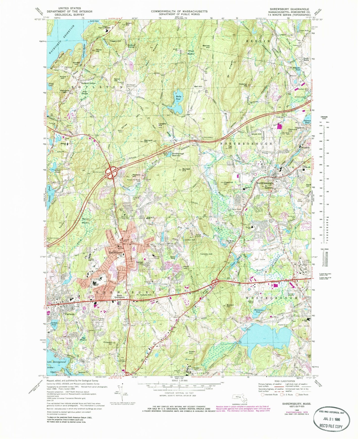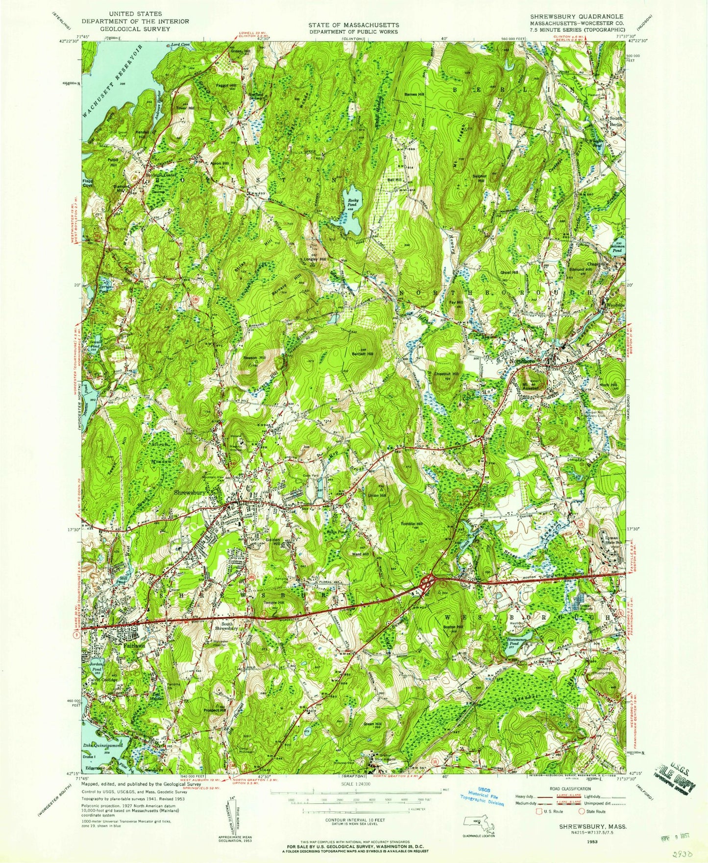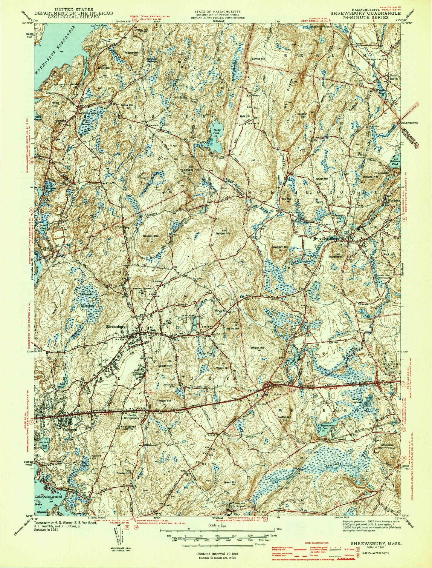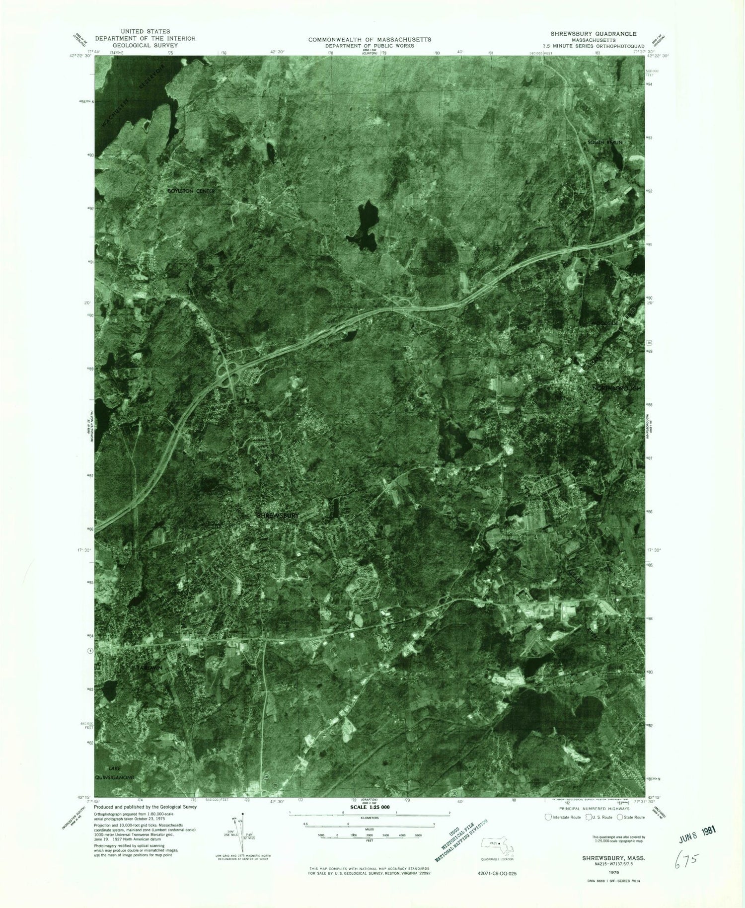


MyTopo
Classic USGS Shrewsbury Massachusetts 7.5'x7.5' Topo Map
Couldn't load pickup availability
Historical USGS topographic quad map of Shrewsbury in the state of Massachusetts. Typical map scale is 1:24,000, but may vary for certain years, if available. Print size: 24" x 27"
This quadrangle is in the following counties: Middlesex, Worcester.
The map contains contour lines, roads, rivers, towns, and lakes. Printed on high-quality waterproof paper with UV fade-resistant inks, and shipped rolled.
Contains the following named places: Longley Hill, Joseph G Pyne School, Westborough Junior High School, Shrewsbury High School, Shrewsbury Junior High School, Masonic Hospital, Pine Grove Cemetery, Mountain View Cemetery, Juniper Hill Country Club, South Berlin Cemetery, Calvin Coolidge School, Worcester Hospital, Camp Wunnegon, Grafton State Hospital, Grafton State Hospital Memorial Cemetery, Lyman State School, Westboro Country Club, Fairlawn Shopping Center, Westmeadow Plaza, White City and White City East Shopping Center, Hillcrest Cemetery, Grafton State Hospital, Camp Wunnegan, Calvin Coolidge School, Lyman State School, Fannie E Proctor School, Lincoln Street School, Zeh School, Howard Street Cemetery, George H Nichols Dam, Fraser Junior High School, Saint Johns High School, Walter J Paton School, Boylston Elementary School, Beal High School, Masonic Nursing Home, Rawson Hill Brook Dam, Spring Street School, Center School, Retreat House, Dean Park, Tahanto Regional High School, Mount Pleasant Country Club, Pleasant Street Cemetery, Wekepeke Brook, George H Nichols Reservoir, Mill Pond Dam, Smith Pond Dam, Hop Brook Reservoir, Cold Harbor Brook Reservoir, Newton Pond Dam, Rawson Mill Brook Dam A-4-A, Rawson Mill Brook Reservoir, Northborough Reservoir Dam, Assabet River Reservoir, Assabet River Dam, Bushs Pond (historical), Meeting House Hall, Newton Pond, Apron Hill, Mount Assabet, Ball Hill, Barnes Hill, Barnard Hill, Bartlett Hill, Boston Hill, Boylston Center, Chestnut Hill, Cold Harbor Brook, Cooledge Brook, Cushing Swamp, Diamond Hill, East Woods, Eaton Pond, Edmund Hill, Faggot Hill, Fairlawn, Fay Hill, French Brook, Ghost Hill, Golden Hill, Green Hill, Green Hill, Hocomonco Pond, Hop Brook, Howard Brook, Jordan Pond, Kendall Hill, Malagasco Brook, Meadow Brook, Mill Pond, Northborough, Peat Meadow, Pine Swamp, Mount Pisgah, Potash Brook, Prospect Hill, Pulpit Hill, Rawson Hill, Rawson Hill Brook, Rock Hill, Rocky Pond, Scar Hill Bluffs, Scotland Swamp, Sewall Pond, Sewall Hill, Shrewsbury, Slocum Meadow, Smith Pond, Solomon Pond, South Berlin, South Shrewsbury, Spruce Pond, Stiles Hill, Straw Hollow, Sulphur Hill, Temple Hill, Tomblin Hill, Tower Hill, Union Hill, Ward Hill, Wheeler Pond, Woodside, Wrack Meadow, Northborough Reservoir, Stony Brook, Barefoot Brook Dam, Brewer Brook, Brewer Brook Dam, Cold Harbor Brook Dam, Hop Brook Dam, Wessonville, Town of Northborough, Andrews Harbor, Flagg Cove, Lord Cove, WICN-FM (Worcester), WHLL-TV (Worcester), Berlin Landing Area Airport (historical), Shrewsbury Heliport, Town of Boylston, Town of Shrewsbury, Berlin Post Office, Church of the Nativity, First Congregational Church, General Artemas Ward House, George F Fuller Research Library, Good Shepherd Lutheran Church, Grace Baptist Church, Grafton Hospital (historical), Hills Farm Industrial Park, Jordan Pond Recreation Area, Marguerite E Peaslee School, Massachusetts Microelectronic Center, Mill Pond Park, Montessori Elementary School, Mount Olivet Lutheran Church, New England Baptist Convention Church, Northborough Free Library, Northborough Middle School, Northborough Post Office, Northborough Town Hall, Old Burial Ground, Olde Shrewsbury Village Shopping Center, Rice Memorial Baptist Church, Saint Johns Athletic Field, Saint Marys Assyrian Orthodox Church, Saint Marys Pastoral Center, Saint Marys School, Saint Rose of Lima Parish Church, Sarah W Gibbons Middle School, Seventh Day Adventist Church, Shrewsbury Crossing Shopping Center, Shrewsbury Historic District, Shrewsbury Middle School, Shrewsbury Post Office, Shrewsbury Public Library, Shrewsbury Senior High School, Speedway Plaza Shopping Center, Trinity Church, Trinity Episcopal Church, Turnpike Post Office, Ward Corner, Westborough Country Club, Worcester Foundation for Biomedical Research, Melican Middle School Library, Robert E Melican Middle School, Floral Street School, Shrewsbury High School Library Media Center, Tower Hill Botanic Garden Library, Westborough Station, YMCA Center for Child Care, Northborough Census Designated Place, Tougas Family Farm, Boylston Fire Station, Shrewsbury Fire Department Station Headquarters, Northborough Fire Department, Shrewsbury Fire Department Station 2 Lake Station, Shrewsbury Police Department, Northborough Police Department, Boylston Post Office, Old Burial Ground Cemetery, Longley Hill, Joseph G Pyne School, Westborough Junior High School, Shrewsbury High School, Shrewsbury Junior High School, Masonic Hospital, Pine Grove Cemetery, Mountain View Cemetery, Juniper Hill Country Club, South Berlin Cemetery, Calvin Coolidge School, Worcester Hospital, Camp Wunnegon, Grafton State Hospital, Grafton State Hospital Memorial Cemetery, Lyman State School, Westboro Country Club, Fairlawn Shopping Center, Westmeadow Plaza, White City and White City East Shopping Center, Hillcrest Cemetery, Grafton State Hospital, Camp Wunnegan, Calvin Coolidge School, Lyman State School, Fannie E Proctor School, Lincoln Street School, Zeh School, Howard Street Cemetery, George H Nichols Dam, Fraser Junior High School, Saint Johns High School, Walter J Paton School, Boylston Elementary School