MyTopo
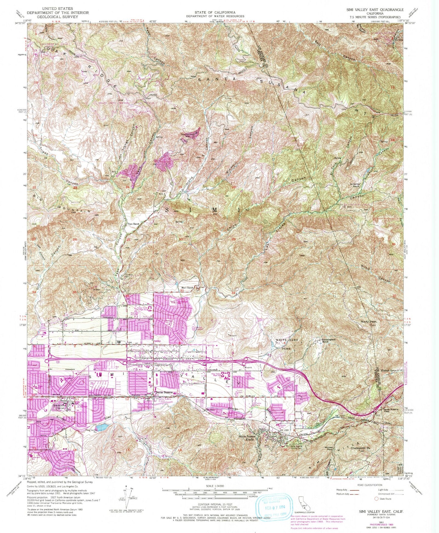
Classic USGS Simi Valley East California 7.5'x7.5' Topo Map
Couldn't load pickup availability
Historical USGS topographic quad map of Simi Valley East in the state of California. Typical map scale is 1:24,000, but may vary for certain years, if available. Print size: 24" x 27"
This quadrangle is in the following counties: Los Angeles, Ventura.
The map contains contour lines, roads, rivers, towns, and lakes. Printed on high-quality waterproof paper with UV fade-resistant inks, and shipped rolled.
Contains the following named places: Belwood School, Big Springs Elementary School, Black Canyon, Simi Valley Adult Education Center, Chatsworth Peak, Chivo Canyon, Crestview Elementary School, Dry Canyon, El Toro Canyon, Gillibrand Canyon, Hialeah Springs, Hummingbird Ranch, Iron Trough Canyon, Katherine Elementary School, Knolls School, La Quinta Ranch, Las Llajas Canyon, Marr Ranch, Meier Canyon, Oak Canyon, Oak Ridge, Pioneer Pass, Rocky Peak, Runkle Canyon, Santa Susana, Santa Susana County Park, Santa Susana Pass, Santa Susana Tunnel, Simi Civic Center, Simi Elementary School, Simi Valley High School, Sulphur Canyon, Sycamore Elementary School, Tapo Canyon, Tapo Gillibrand Mine, Tapo Ranch, Township Elementary School, Tripas Canyon, Valley View Junior High School, Vista School, White Oaks Park, Windmill Canyon, Las Llajas Oil Field, Santa Susana Oil Field, Simi Oil Field, South Tapo Canyon Oil Field, Tapo Ridge Oil Field, First Interstate Bank Heliport, Simi Valley, Community Center, Santa Susana Knolls, KWNK-AM (Simi Valley), La Quinta, Coquina Mine, Hall Ranch (historical), Hog Canyon, Oak Park Ranch, Apolo High School, Arroyo Stow Park, Bellwood Shopping Center, Brandeis-Barden Institute, Callahan Field, Calvary Baptist Church of Simi Valley, Calvary Church of Simi Valley, Centerpoint Plaza Shopping Center, Chumash Park, Church of God Nuevo Pacto, Church of Jesus Christ in the Americas, Church of the Living Christ, Cochran Baptist School, Cochran Street Baptist Church, Congregation B'nai Emet, Corriganville, Darrah Park, First Christian Church of Simi Valley, Foothill Park, Garden Grove Elementary School, Glory House, Grace Brethren Church of Simi Valley, Grace Brethren Preparatory School, Handicapped Childrens School, Houghton Schreiber Park, Jehoshaphat Missionary Baptist Church, Knolls Park, Mid-Valley Congregation Kingdom Hall of Jehovahs Witnesses, Mountain View Elementary School, New Apostolic Church, New Beginnings Christian Fellowship Church, Pinecrest School, Rancho Santa Susana Community Park, Rancho Tapo Community Park, Reorganized Church of Jesus Christ of Latter Day Saints, Royal Avenue Baptist Church, Saint Peter Claver Church, Santa Susana Elementary School, Sequoia Junior High School, Sequoia Park, Simi Hills Golf Course, Simi Hills Neighborhood Park, Adventist Health Simi Valley, Simi Valley Adventist Hospital Medical Library, Simi Valley City Hall, Simi Valley Library, Simi Valley Missionary Baptist Church, Simi Valley Presbyterian Church, Stone Gate Shopping Center, Sycamore Community Center, Sycamore Park, Sycamore Square Shopping Center, Tapo Oaks Shopping Center, Tapo Plaza Shopping Center, The Church of Jesus Christ, Valley Bible Community Church, Verde Park, White Oak Elementary School, Simi Valley Division, City of Simi Valley, Well Number Four, Pico Canyon Oil Field, Santa Susana Census Designated Place, Ventura County Fire Protection District Station 41, Ventura County Fire Protection District Station 46 Tapo Street, Simi Valley Police Department, Mount Sinai Memorial Park, Simi Valley Post Office