MyTopo
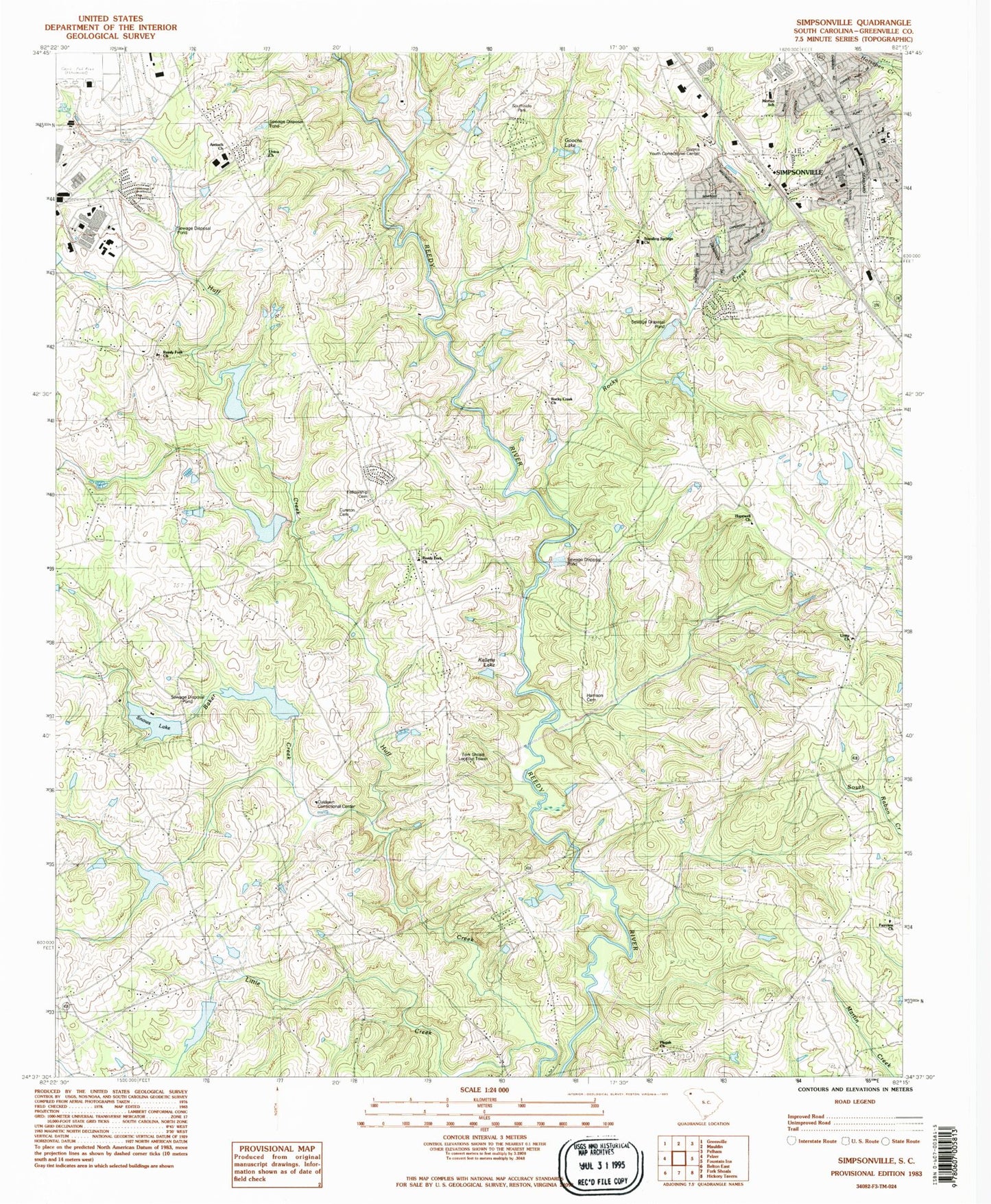
Classic USGS Simpsonville South Carolina 7.5'x7.5' Topo Map
Couldn't load pickup availability
Historical USGS topographic quad map of Simpsonville in the state of South Carolina. Typical map scale is 1:24,000, but may vary for certain years, if available. Print size: 24" x 27"
This quadrangle is in the following counties: Greenville.
The map contains contour lines, roads, rivers, towns, and lakes. Printed on high-quality waterproof paper with UV fade-resistant inks, and shipped rolled.
Contains the following named places: Baker Creek, Cureton Cemetery, Fellowship Cemetery, Goochs Lake, Harrison Cemetery, Kelletts Lake, Reedy Fork Church, Snows Lake, Union Church, South Carolina Noname 23007 D-2890 Dam, Huff Creek Watershed Lake, South Carolina Noname 23008 D-2889 Dam, Water Shed Number One Reservoir, South Carolina Noname 23009 D-2879 Dam, Water Shed Number Two Reservoir, South Carolina Noname 23010 D-2880 Dam, Water Shed Three Reservoir, South Carolina Noname 23011 D-2877 Dam, Water Shed Four Reservoir, South Carolina Noname 23013 Dam, Trollingwood Lake Dam D-2878, Riddle Lake Dam D-2895, Trickle Lake Dam D-2896, Brooks Pond Dam D-2897, Pete Pond Dam Number One D-2898, Pete Pond Dam Number Two D-2899, A Taylor Pond Dam Number One D-2907, A Taylor Pond Dam Number Two D-2908, Fork Shoals Lookout Tower, Antioch Church, Antioch Cemetery, Ashmore Store (historical), Bonnie Brae Golf Course, Brentwood, Cherokee Heights, Church of God, Dacus Shoals, Fairview Presbyterian Church Graveyard, Fairview School (historical), Fellowship Church (historical), Givens Youth Correctional Center, Great Cane Brake, Harrison Bridge, Hejaz Shrine Country Club, Holcombe Store (historical), Hopewell United Methodist Graveyard, Hopewell School (historical), Huff Bridge, Hunters Woods, Idlewild, Jenkins Bridge, Log Shoals Bridge, Morton School, Old Hundred School (historical), Pine Brook Forest, Pisgah United Methodist Church Cemetery, Plain Elementary School, Putnam Store (historical), Reedy Fork Baptist Church Graveyard, Rock Creek School (historical), Rock Hill School (historical), Saint Albans School (historical), Shiloh Estates, Simpsonville Elementary School, Simpsonville Municipal Cemetery, Simpsonville Plaza Shopping Center, Simpsonville Post Office, Simpsonville Shopping Center, Southside Park, Standing Springs Baptist Church Graveyard, Standing Springs School (historical), Unity Baptist Church Graveyard, Wassorf Store (historical), Westwood, Westwood South, Hopewell Church, Huff Creek, Fairview Presbyterian Church, Oaklawn Correctional Center, Pisgah Church, Reedy Fork Church, Rocky Creek, Rocky Creek Church, Saint Albans School (historical), Simpsonville, Standing Springs Church, Unity Church, WROQ-FM (Anderson), WAXA-TV (Anderson), City of Simpsonville, Simpsonville Fire Department Station 2, South Greenville Fire Department Station 3, Simpsonville Fire Department Headquarters, Canebrake Fire Department Main Station, Simpsonville Fire Department Station 4, South Greenville Fire Department Station 6, Perry Correctional Institution Medical Center Infirmary, Simpsonville Police Department, Perry Correctional Institution, Canebrake Fire Department Station 3