MyTopo
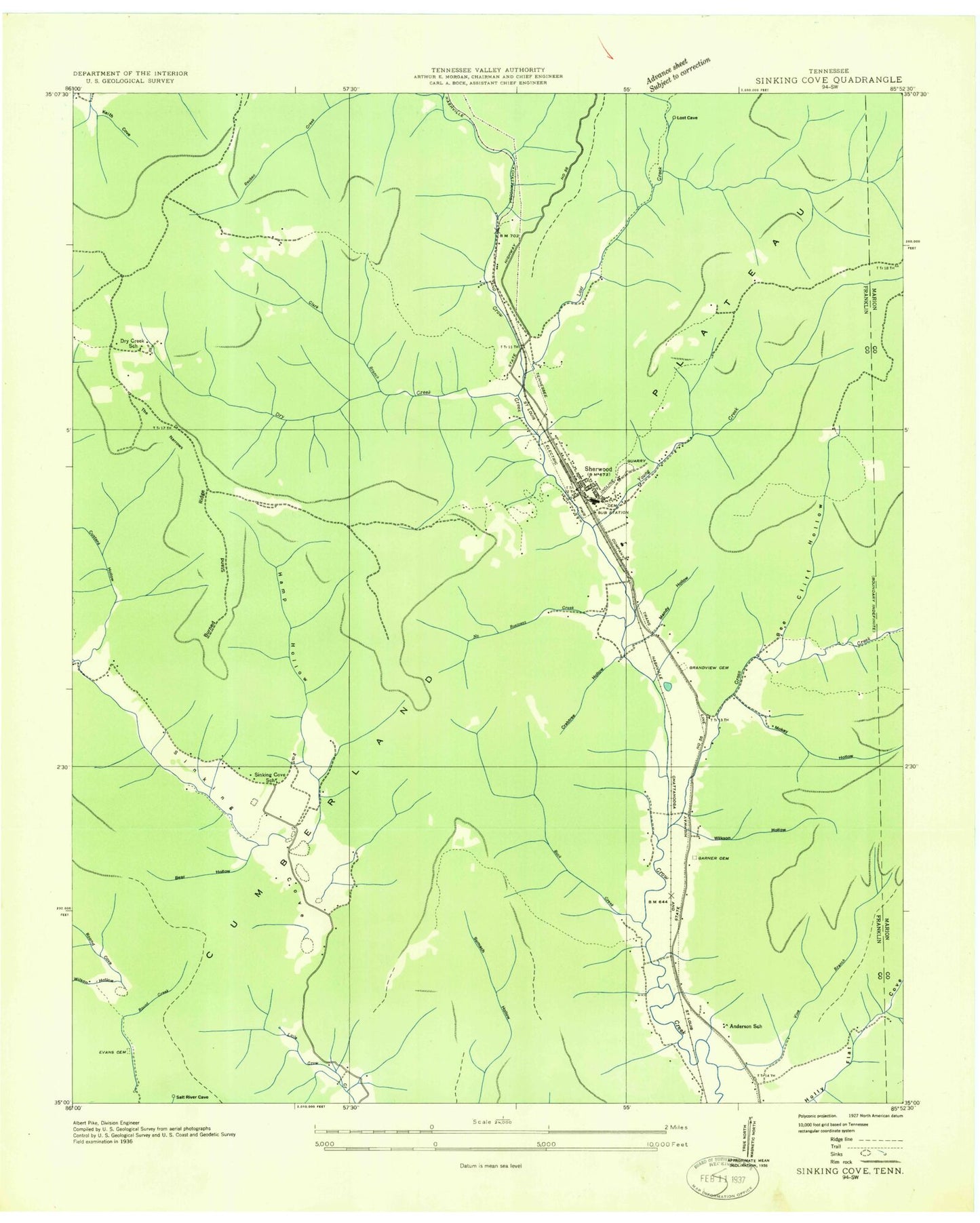
Classic USGS Sinking Cove Tennessee 7.5'x7.5' Topo Map
Couldn't load pickup availability
Historical USGS topographic quad map of Sinking Cove in the state of Tennessee. Typical map scale is 1:24,000, but may vary for certain years, if available. Print size: 24" x 27"
This quadrangle is in the following counties: Franklin.
The map contains contour lines, roads, rivers, towns, and lakes. Printed on high-quality waterproof paper with UV fade-resistant inks, and shipped rolled.
Contains the following named places: Sinking Cove, Sinking Cove School, The Narrows, The Spur, Tom Pack Hollow, Vaughn Hollow, Wilkson Hollow, Winding Stairs, Anderson School, Apps Hollow, Barnes Point, Bear Hollow, Bee Cliff Hollow, Brush Creek, Buck Creek, Cane Hollow, Cedar Ridge, Crabtree Hollow, Cross Creek, Crownover Cemetery, Custard Hollow, Dry Creek, Garner Cemetery, Gass Cemetery, Gonce Cemetery, Hamp Hollow, Holly Flat Cove, Hoosier Cemetery, Jackson Cemetery, Lick Hollow, Long Hollow, Los Cove, Lynch Cemetery, Mandy Hollow, Mokay Hollow, Morris Cemetery, Narrows Hollow, No Business Creek, Pumplog Hollow, Red Hill Cemetery, Round Cove, Rush Creek, Sherwood, Stubblefield Hollow, Wilkinson Hollow, Youngs Creek, Burned Stand Ridge, Clark Branch Creek, Vine Branch, Tantallon, Presley Cemetery, Sinking Cove, Dry Creek School (historical), Mister and Mrs Larry Lee Carter Natural Area, Willard Cemetery, Sherwood Cemetery, Sherwood Elementary School, Sherwood Division (historical), Sherwood Post Office, Commissioner District 5, Crow Creek Valley Volunteer Fire Department Station 1, Crow Creek Valley Volunteer Fire Department, Sherwood Census Designated Place, Sinking Cove, Sinking Cove School, The Narrows, The Spur, Tom Pack Hollow, Vaughn Hollow, Wilkson Hollow, Winding Stairs, Anderson School, Apps Hollow, Barnes Point, Bear Hollow, Bee Cliff Hollow, Brush Creek, Buck Creek, Cane Hollow, Cedar Ridge, Crabtree Hollow, Cross Creek, Crownover Cemetery, Custard Hollow, Dry Creek, Garner Cemetery, Gass Cemetery, Gonce Cemetery, Hamp Hollow, Holly Flat Cove, Hoosier Cemetery, Jackson Cemetery, Lick Hollow, Long Hollow, Los Cove, Lynch Cemetery, Mandy Hollow, Mokay Hollow, Morris Cemetery, Narrows Hollow, No Business Creek, Pumplog Hollow, Red Hill Cemetery, Round Cove, Rush Creek, Sherwood, Stubblefield Hollow, Wilkinson Hollow, Youngs Creek, Burned Stand Ridge, Clark Branch Creek, Vine Branch, Tantallon, Presley Cemetery, Sinking Cove, Dry Creek School (historical), Mister and Mrs Larry Lee Carter Natural Area, Willard Cemetery, Sherwood Cemetery, Sherwood Elementary School, Sherwood Division (historical), Sherwood Post Office, Commissioner District 5, Crow Creek Valley Volunteer Fire Department Station 1, Crow Creek Valley Volunteer Fire Department, Sherwood Census Designated Place