MyTopo
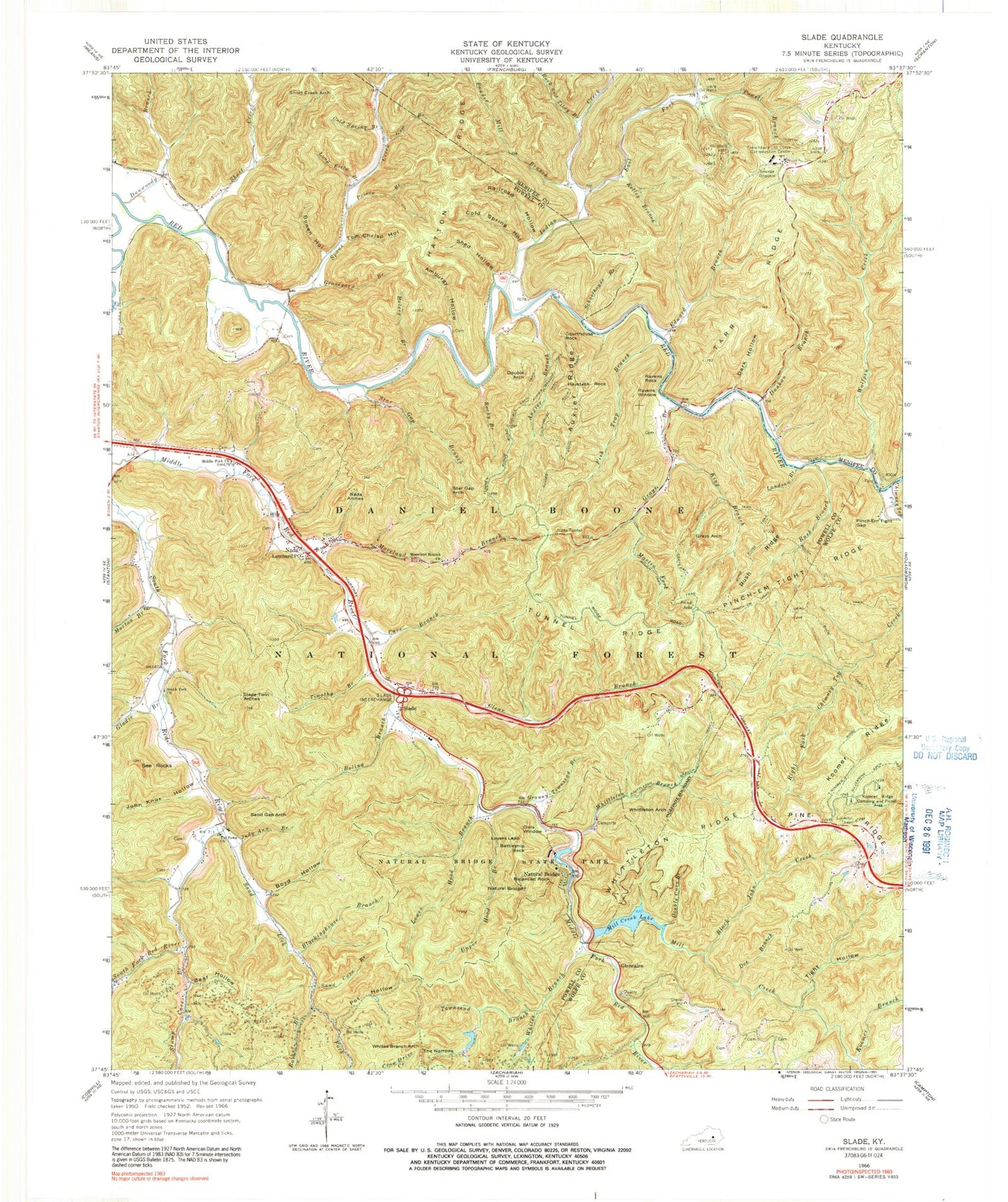
USGS Classic Slade Kentucky 7.5'x7.5' Topo Map
Couldn't load pickup availability
Historical USGS topographic quad map of Slade in the state of Kentucky. Scale: 1:24000. Print size: 24" x 27"
This quadrangle is in the following counties: Menifee, Powell, Wolfe.
The map contains contour lines, roads, rivers, towns, lakes, and grids including latitude / longitude and UTM / MGRS. Printed on high-quality waterproof paper with UV fade-resistant inks.
Contains the following named places: Amburgy Hollow, Auxier Branch, Auxier Branch Trail, Auxier Ridge, Auxier Ridge Trail, Balanced Rock, Barker Branch, Battleship Rock, Bear Hollow, Big Cordual Branch, Black John Creek, Blackinghouse Branch, Boling Branch, Bowen Hollow, Boyd Hollow, Buck Trail, Cave Branch, Chimney Top Creek, Clear Branch, Cold Spring Branch, Cold Spring Hollow, Courthouse Rock, Courthouse Rock Trail, Dark Hollow, Doe Branch, Double Arch, Double Arch Trail, Double Cave Branch, Dunkan Branch, Dunwoody Branch, East Fork Indian Creek, Edward Branch, Fish Trap Branch, Gladie Branch, Glencairn, Granny Townsend Branch, Graveyard Branch, Grays Arch, Grays Branch, Graysarch Trail, Halsey Branch, Haystack Rock, Indian Creek, John Knox Hollow, Judy Ann Branch, Kelley Branch, King Branch, Koomer Branch, Koomer Ridge, Koomer Ridge Camping and Picnic Area, Koomer Ridge Trail, Landsome Branch, Long Field Branch, Lovers Leap, Lower Hood Branch, Martin Fork, Middle Fork Church, Mill Creek, Mill Creek Lake, Moreland Branch Church, Moreland Branch, Morton Branch, Nada Arches, Nada Lombard Post Office, Nada Tunnel, Natural Bridge, Natural Bridge, Natural Bridge State Park, Owls Window, Pinch-Em Tight Ridge, Pinch-Em Tight Gap, Pinch-Em Tight Trail, Pine Ridge, Pot Hollow, Powder Mill Branch, Powell Branch, Prince Branch, Railroad Hollow, Ravens Rock, Ravens Window, Rock and Tildy Branch, Rocky Branch, Rough Trail, Rush Branch, Rush Ridge, Sand Cave Branch, Sand Gap Arch, Sand Lick Fork, Schoolhouse Branch, See Rocks, Shed Hollow, Short Creek, Short Creek Arch, Silvermine Arch Trail, Slade, Slade Twin Arches, South Fork Church, Spaas Creek, Star Gap Arch, Star Gap Branch, Stump Cave Branch, Tarr Ridge, The Narrows, Tight Hollow, Timothy Branch, Tin Town Church, Tom Chrisp Hollow, Townsend Branch, Tunnel Ridge, Upper Hood Branch, Whites Branch, Whites Branch Arch, Whittleton Arch, Whittleton Branch, Whittleton Branch Trail, Whittleton Ridge, Wolfpen Creek, Whittleton Campground, Middle Fork Campground, Grays Arch Picnic Area, Hidden Arch, Amphitheater Trail, Tarr Ridge Picnic Area, Grays Arch Trail, Gum Branch, Rush Ridge Trail, Frenchburg Correctional Facility, Natural Bridge Post Office (historical), South Fork Twin Arches, Beasley Hollow, Chimney Top Railroad Station (historical), Cloud Splitter Rock, Glencairn Post Office (historical), Glencairn Railroad Station (historical), Mountain Top Railroad Station (historical), Pine Ridge Lookout Tower, Big Woods School (historical), Haystack Post Office (historical), Dunkan Branch Hill, Henson Cave Arch, The Silver Bridge, Dunwoody Church, Glencairn Church, Hoedown Island, Lookout Point, Nada Railroad Station (historical), Natural Bridge Station (historical), Needle Eye, Slade Railroad Station (historical), The Devils Pulpit, Big Sinking Oil Field, Junior Williamson Rest Area, Crow (historical), Fortner (historical), Old Lombard (historical), South Fork (historical), Spaas Creek (historical), Bragg Post Office (historical), Clida Post Office (historical), Haystack Post Office (historical), See Post Office (historical), Slade Post Office, Spaas Creek Post Office (historical), Barker School (historical), Glencairn School (historical), Slade Hill, DeHart Hollow, Middlefork Fire Department