MyTopo
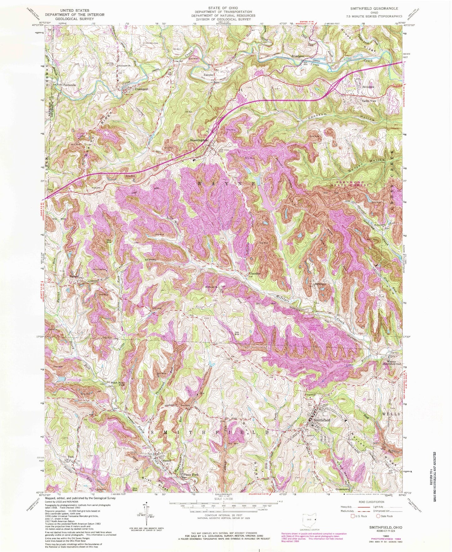
Classic USGS Smithfield Ohio 7.5'x7.5' Topo Map
Couldn't load pickup availability
Historical USGS topographic quad map of Smithfield in the state of Ohio. Map scale may vary for some years, but is generally around 1:24,000. Print size is approximately 24" x 27"
This quadrangle is in the following counties: Harrison, Jefferson.
The map contains contour lines, roads, rivers, towns, and lakes. Printed on high-quality waterproof paper with UV fade-resistant inks, and shipped rolled.
Contains the following named places: Beacon Ridge, Belvedere, Belvedere Volunteer Fire Department, Bloomingdale, Bloomingdale Cemetery, Bloomingdale Fire Department, Bloomingdale Post Office, Blue Ridge, Boich Mining Company Pond Number One, Boich Mining Company Pond Number One Dam, Boich Mining Company Pond Number Two, Boich Mining Company Pond Number Two Dam, Brier Ridge, Broadacre, Broadacre Post Office, Cedar Lick Creek, Chandler, Chandler Post Office, Clay Lick Creek, Consolidation Coal Company Pond 0206, Fair Play Post Office, Fairplay, Ferguson Cemetery, Friends Cemetery, Friendship Airpark, Friendship Park Lake, Friendship Park Lake Dam, Greentown, Harrah Run, Henderson Run, Jefferson Sportsmens Lake Number One, Jefferson Sportsmens Lake Number One Dam, Jefferson Sportsmens Lake Number Three, Jefferson Sportsmens Lake Number Three Dam, Jefferson Sportsmens Lake Number Two, Jefferson Sportsmens Lake Number Two Dam, Little McIntyre Creek, Little Piney Fork, McIntyre, McIntyre African Methodist Episcopal Cemetery, Mingo Sportsmens Club Lake Number, Mount Moriah Cemetery, Mount Moriah Church, Newell, North Branch Cross Creek, Northern Cemetery, Opossum Hollow, Panhandle, Panhandle Post Office, Parlett, Parlett Post Office, Pine Run, Pine Run Cemetery, Pine Valley Sportsmens Lake Number, Piney Fork, Piney Fork Cemetery, Saint James Cemetery, Saint James Church, Salem Creek, Short Creek Joint Fire District Station 2, Smithfield, Smithfield Census Designated Place, Smithfield Elementary School, Smithfield Lions Club Lake, Smithfield Lions Club Lake Dam, Smithfield Police Department, Smithfield Post Office, Smithfield Volunteer Fire Department, Steubenville Post Office, Thompson Run, Township of Wayne, Unionport, Unionport Cemetery, Unionport Christian Church, Unionport post office, Unionport Volunteer Fire Department, Valley View, Village of Bloomingdale, Village of Smithfield, Warren Ridge, Wayne Elementary School, Weems, Weems Post Office, Witch Hazel Pond, Woods Run, WWYS-FM (Cadiz), York, ZIP Codes: 43910, 43948