MyTopo
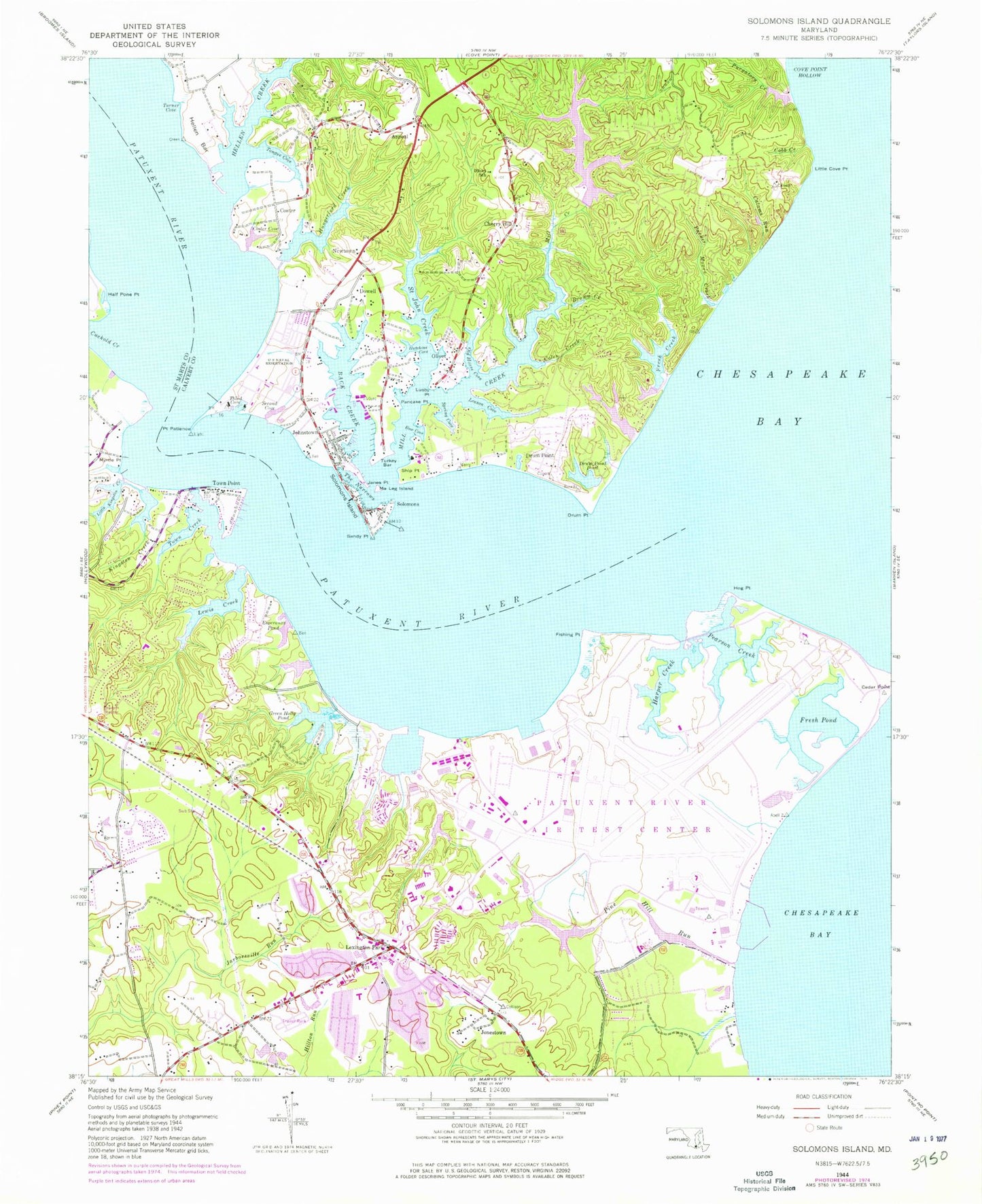
Classic USGS Solomons Island Maryland 7.5'x7.5' Topo Map
Couldn't load pickup availability
Historical USGS topographic quad map of Solomons Island in the state of Maryland. Typical map scale is 1:24,000, but may vary for certain years, if available. Print size: 24" x 27"
This quadrangle is in the following counties: Calvert, St. Mary's.
The map contains contour lines, roads, rivers, towns, and lakes. Printed on high-quality waterproof paper with UV fade-resistant inks, and shipped rolled.
Contains the following named places: Appeal, Back Creek, Bow Cove, Brooks Cove, Brown Creek, Calams Run, Cobb Creek, Coles Creek, Coster Cove, Drum Point, Drum Point Pond, Fishing Creek, Hellen Bar, Hellen Creek, Hutchins Cove, Janes Point, Leason Cove, Little Cove Point, Lusby Point, Ma Leg Island, Mill Creek, Old House Cove, Olivet School, Pancake Point, Parker Moore Creek, Purgatory Creek, Saint John Creek, Sandy Point, Second Cove, Ship Point, Spring Cove, The Narrows, Third Cove, Tongue Cove, Turkey Bar, Turner Cove, Hoopers Neck, Lake Vista, Hungerford Creek, Lusby Cove, Cherry Hill, Coster, Dowell, Drum Point, Johnstown, Newtown, Olivet, Solomon (historical), Summerville (historical), Solomons Island, Lake Charming, Chesapeake Ranch Club Dam, Chesapeake Ranch Club Lake, Pond Number 3 Dam, Pond Number Three Dam, Pond Number Three, Esperanza Pond, Fishing Point, Goose Creek, Green Holly Pond, Half Pone Point, Harper Creek, Hog Point, Jonestown, Kingston Creek, Lewis Creek, Lexington Park, Little Kingston Creek, Myrtle Point, Pearson Creek, Pine Hill Run, Point Patience, Town Creek, Town Creek, Town Point, Spencers Wharf, Chesapeake Ranch Airport, Mears Creek Airfield, Patuxent River Naval Air Station/Trapnell Field, Patuxent River, Saint Marys River State Park, Avondale Center Shopping Center, Barrett Island, Blunts Cove, Brick Landing, Burrell Branch, Calvert Marine Museum, Carol Court, Chesapeake Biological Laboratory, Chesapeake Ranch Estates, Chesapeake Ranch Estates Campground, Chesapeake Woods, Cleve Branch, Cliffs of Calvert, Cobb Landing, Cove Lake, Cove View, Dowell Post Office, Driftwood Beach, Drum Point Lighthouse, Eastern Church, Green Hills, Harbor Light Beach, Hellen Creek Estates, Hemlock Estates, Hoopers Neck, Lake Lariat, Lord Calvert Yacht Club, Old Hickory, Old House Cove Estates, Olivet United Methodist Church, Our Lady Star of the Sea Roman Catholic Church, Our Lady Star of the Sea School, Park Chesapeake, Patuxent Plaza Shopping Center, Preston Point, River View, Rousby Hall, Saint Johns Creek, Saint Johns Woods, Saint Peters Episcopal Church, Seashore Beach, Ship Point Research Park, Solomons, Our Lady Star of the Sea Cemetery, Solomons Island Cemetery, Solomons Post Office, Solomons United Methodist Church, Spring Cove, Spring Cove Marina, Spruce Hill, The Sounding, Trueman Pointe, Zion Church, California Post Office, Calvary Church, Carver School, Cedar Cove, Chesapeake Bay Basin, Church of God, Church of the Ascension, Colony Square, Discovery, East Patuxent Basin, Ebenezer Cemetery, Ebenezer Church (historical), Ebenezer Church, Esperanza Farm, Esperanza House (historical), Esperanza Middle School, Esperanza Shopping Center, Essex South, Ettonhead Manor House (historical), Evergreen Memorial Gardens, Felix Johnson Education Center, First Pentecostal Church, Cornerstone Presbyterian Church, Forest Park, Frank Knox School, Friendly Pines, Lexington Park Baptist Church, Green Holly Elementary School, Greenview Knolls, Greenview Knolls Elementary School, Halfheads Folly, Hopewell, Immaculate Heart of Mary Church, Inclsey Manor, Jarboesville Park, Kingston, Kingston Manor, Lexington Park Branch Library, Lexington Park Elementary School, Lexington Park Post Office, Lord Baltimores Bay, Mattapanient (historical), Matthews Folly, Millison Plaza Shopping Center, Millstone Landing, National Mobile Home Park, Nicolet Park, Patuxent Park, Pearson (historical), Pearson Post Office (historical), Saint Josephs Manor (historical), Saint Marys Square Shopping Center, Saint Nicholas Church, Saint Richards Manor, San Souci Plaza Shopping Center, Saysf Church, Sherlock Mobile Home Estates, Southgate, Southampton, Spencers Wharf, Spring Valley, Suburban Mobile Estates, Susquehanna (historical), Thomas Johnson Bridge, Thomas Point, Thorns Point, Town Creek Farm, Town Creek Manor, Town Creek Park, Town Creek Elementary School, Trinity Church, West Patuxent Basin, Zion Church, United States Naval Health Clinic Patuxent River, District 8 Bay, Bay District Volunteer Fire Department Company 3, Bay District Volunteer Fire Department Station 9, Lexington Park Volunteer Rescue Squad Company 38, Lexington Park Volunteer Rescue Squad Company 39, Solomons Volunteer Rescue Squad and Fire Department Company 3, Lexington Park Baptist Preschool, Patuxent High School, The Creative Beginnings School, Dowell Elementary School, Greenview Knolls Elementary School, Lexington Park Christian School, Mill Creek Middle School, California Census Designated Place, Chesapeake Ranch Estates-Drum Point Census Designated Place (historical), Lexington Park Census Designated Place, Lusby Census Designated Place, Solomons Census Designated Place, Asbury Assisted Living Center, Calvary Baptist Church, Hermitage at Saint Johns Creek Assisted Living Center, Patuxent Baptist Church, Suburban Estates, Naval Air Station Patuxent River, Solomons Navy Recreation Center, Patuxent River Fire and Emergency Services Patuxent Naval Air Test Center, Chesapeake Ranch Estates Census Designated Place, Drum Point Census Designated Place