
MyTopo
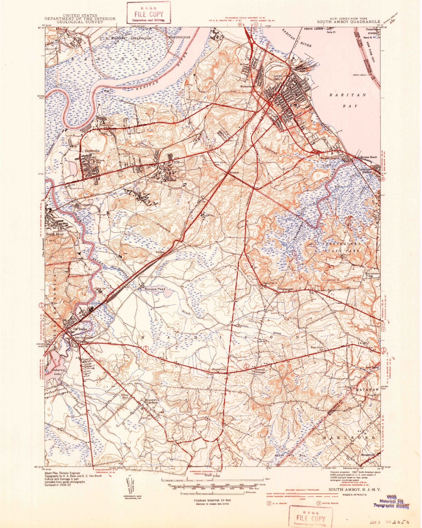
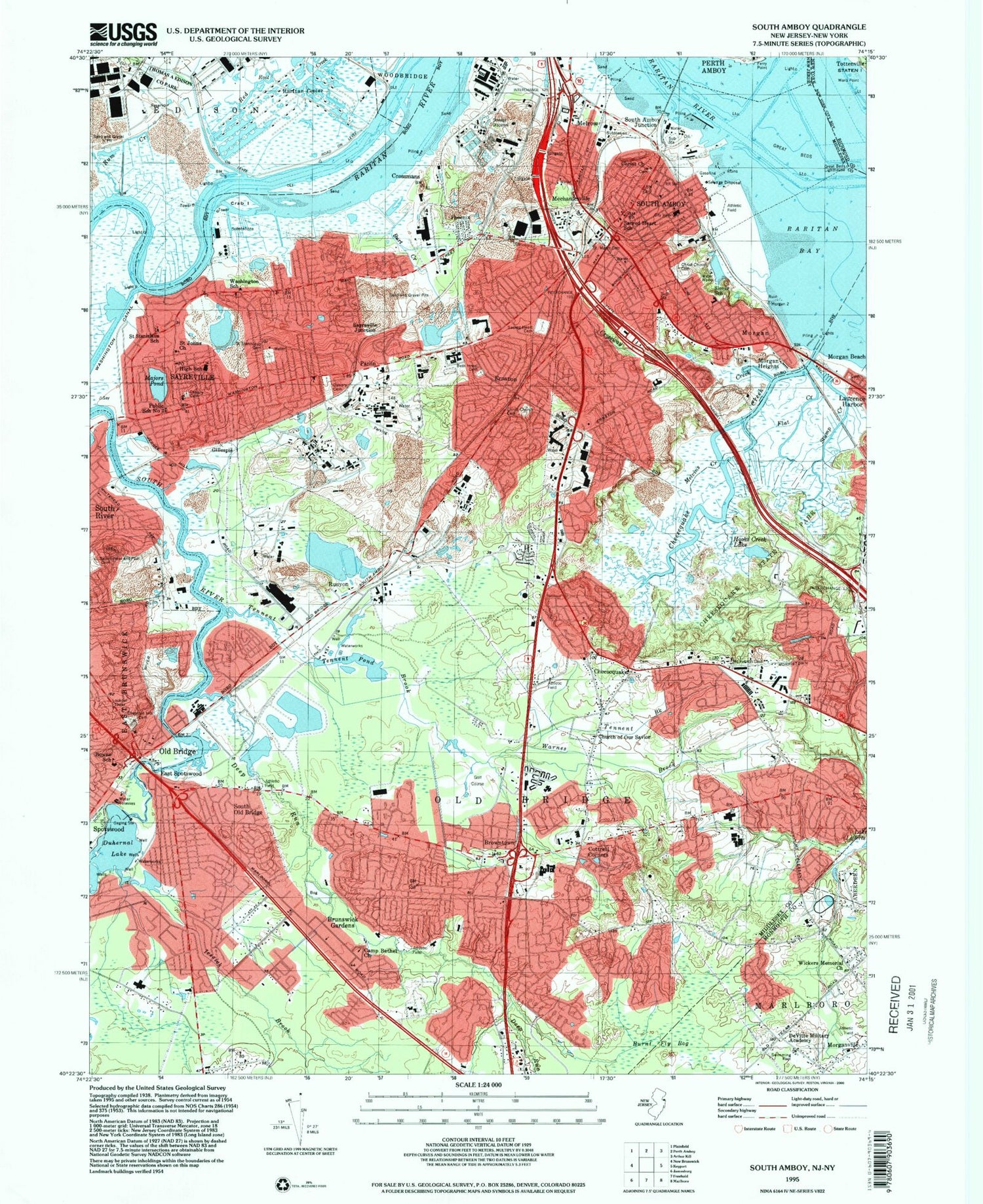
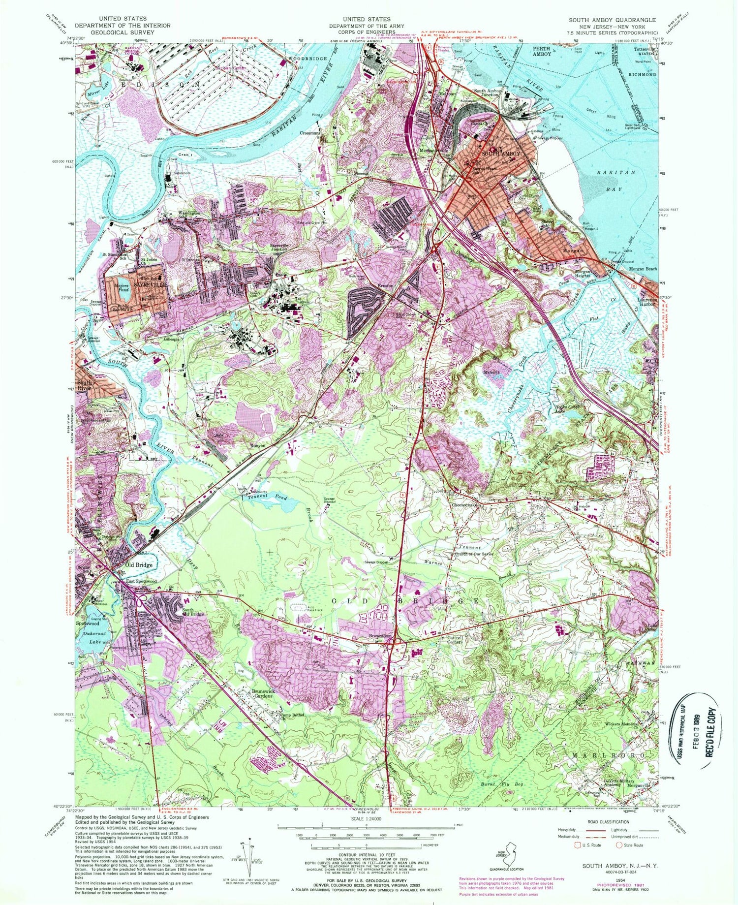
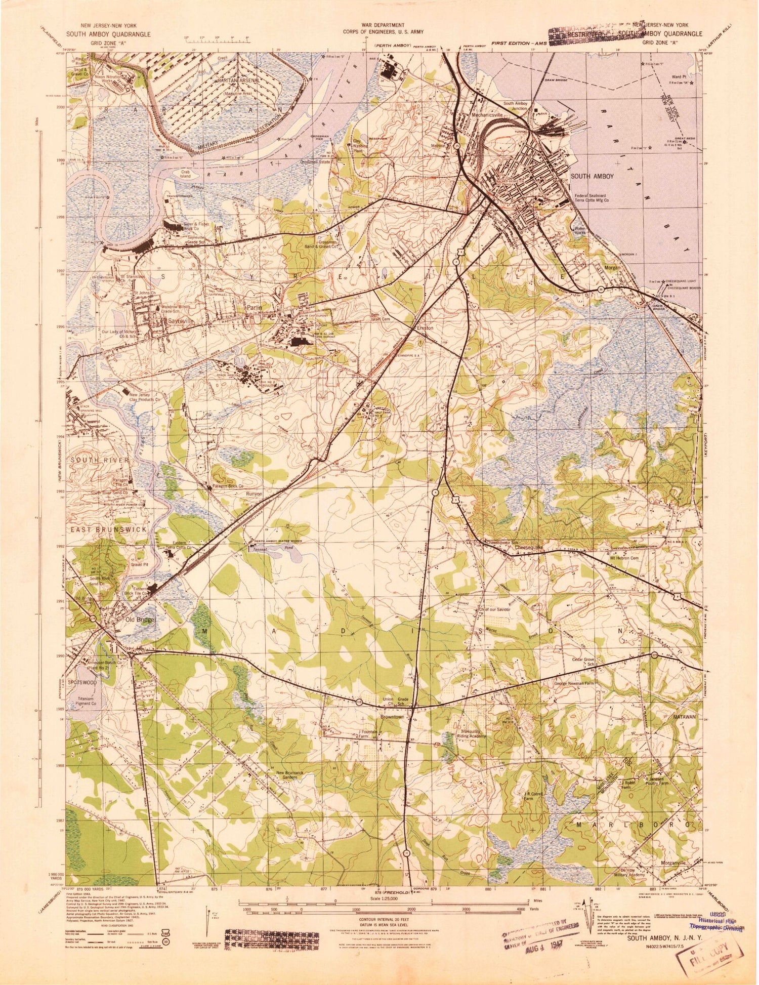
Classic USGS South Amboy New Jersey 7.5'x7.5' Topo Map
Couldn't load pickup availability
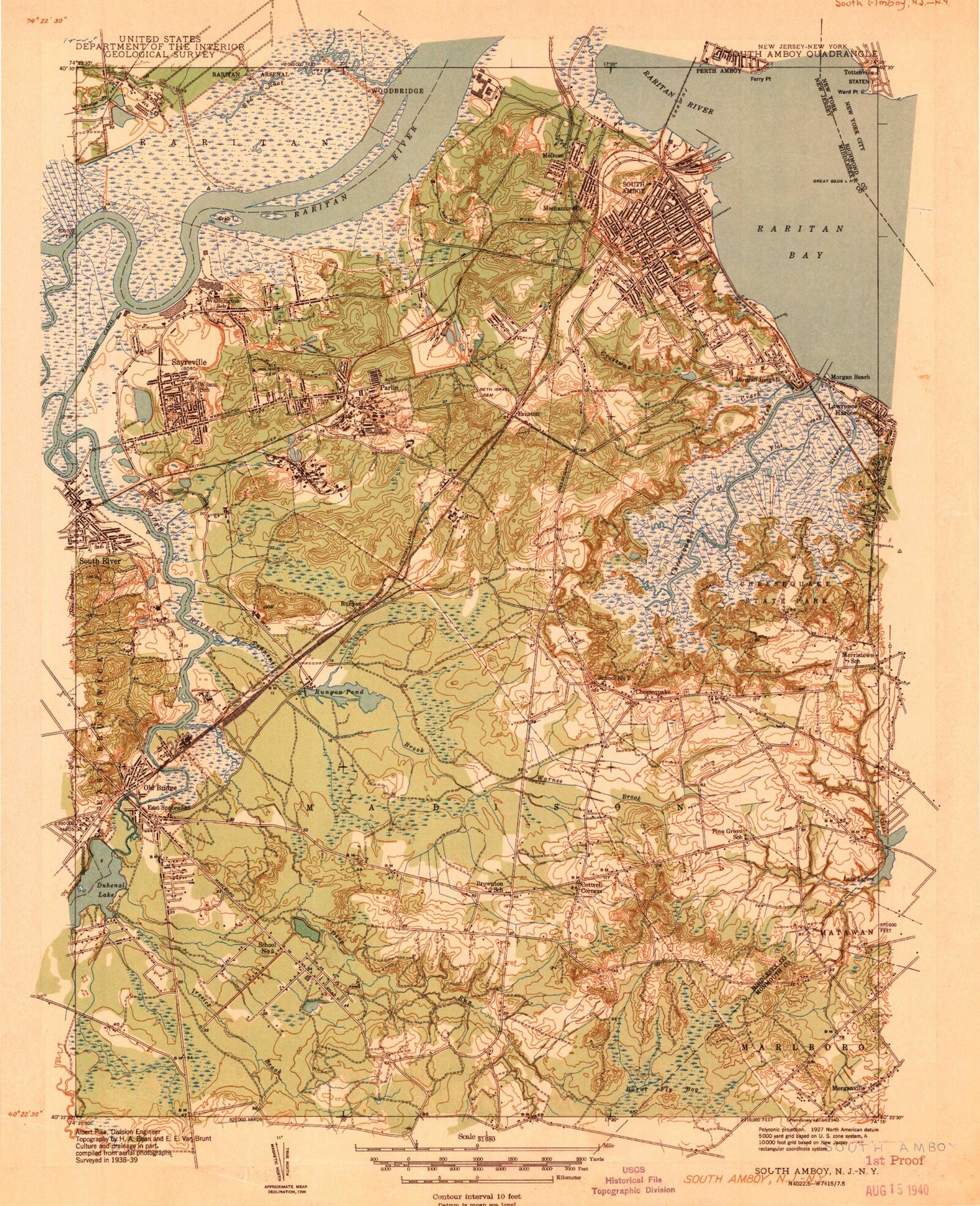
Historical USGS topographic quad map of South Amboy in the states of New Jersey, New York. Typical map scale is 1:24,000, but may vary for certain years, if available. Print size: 24" x 27"
This quadrangle is in the following counties: Middlesex, Monmouth, Richmond.
The map contains contour lines, roads, rivers, towns, and lakes. Printed on high-quality waterproof paper with UV fade-resistant inks, and shipped rolled.
Contains the following named places: Thomas A Edison County Park, Beth Israel Cemetery, Bowne Munro Elementary School, Browntown, Brunswick Gardens, Burnt Fly Bog, Burt Creek, Old Calvary Cemetery, New Calvary Cemetery, Camp Bethel Church, Cheesequake, Cheesequake Creek, Cheesequake State Park, Chestnut Hill Cemetery, Christ Church, Ernst Memorial Cemetery, Christ Church Cemetery, Church of Our Savior, Cottrell Corners, Crab Island, Crossmans, Crossway Creek, DeVitte Military Academy (historical), Deep Run, Duhernal Lake, East Spotswood, Ernston, Ferry Point, Flat Creek, Gillespie, Great Beds, Great Beds Lighthouse, Hooks Creek Lake, Iresick Brook, Majors Pond, Mechanicsville, Melrose, Melvins Creek, Mirror Lake, Morgan, Morgan Beach, Morgan Heights, Mount Hebron Cemetery, Old Bridge, Parlin, Phoenix, Public School Number 2, Raritan River, Rum Creek, Runyon, Sacred Heart Cemetery, Sacred Heart Elementary School, Saint Johns Church (historical), Saint Mary Church Cemetery, Saint Stanislaus Cemetery, Saint Stanislaus Kostka School, Sayreville, Sayreville Junction, Sayreville Station, Slover School, South Amboy, South Amboy Junction, South Old Bridge, Stump Creek, Tennent Brook, Tennent Pond, Warnes Brook, Washington Canal, Washington School, Whited Brown School, Wicker Memorial Baptist Church, Township of Old Bridge, Hercules Parlin (historical), Cruz-Sayreville (historical), Crab Island Reach, Great Beds Reach, Long Reach, Northwest Reach, Raritan River Cutoff, South Amboy Reach, South Channel, MacArthur Manor, Morristown, Madison Park, Laurel Park, Sayre Woods, Sayerwood South, Henningers Mill, Duhernal Dam, Tennent Brook Dam, Parlin East Heliport, Hercules Incorporated Heliport, New Jersey Steel Helistop, Borough of Sayreville, City of South Amboy, Brownville, Raritan Bay Medical Center - Old Bridge, Browntown Shopping Center, Glenwood Golf Course, Old Bridge Township Municipal Complex, Sayre Woods Shopping Center, Bissett's Recreation Area, Keystone Park, Lakeridge Recreation Area, Raritan Bay Waterfront Park, Veteran's Park, Veterans Park Recreation Area, Victory Plaza Circle, Sayreville Fire Department Melrose Hose Company 1, South Amboy Engine Company Number 1, South Amboy Progressive Hose Company Number 1, First Baptist Church, First Methodist Church, First Presbyterian Church, Sacred Heart Roman Catholic Church, Saint Mary's Convent, South Amboy Methodist Protestant Church (historical), South Amboy Memorial Hospital, Christ Episcopal School (historical), Harold G Hoffman High School (historical), Public School Number 2 (historical), Cardinal McCarrick High School, Nativity of Our Lord Byzantine Church, Old Bridge Baptist Church, Union Bible Church, First Presbyterian Church, Sayreville United Methodist Church, Saint Mary's Roman Catholic Church, Saint Peter and Saint Paul Russian Church, Alan B Shepard Elementary School, Carl Sandburg Middle School, James McDivitt Elementary School, John H Glenn Junior School, Jonas Salk Middle School, M Scott Carpenter Elementary School, Old Bridge High School, Raymond E Voorhees Elementary School, Southwood Elementary School, Virgil Grissom Elementary School, Walter M Schirra Elementary School, Arleth Elementary School, Dwight D Eisenhower Elementary School, Harry S Truman Elementary School, Madison Park Elementary School, Sayreville Middle School, War Memorial High School, South Amboy Elementary School, South Amboy Intermediate School, Union Church, Cheesequake Beacon, Cheesequake Light, Crossman Estate (historical), Crossman Pier (historical), George Newman Farm (historical), J Fountain Junior Farm (historical), J R Cotrell Farm (historical), Perth Amboy Water Works, Cedar Grove School (historical), Cheesequake School (historical), Tranquility Riding Academy (historical), Thomas J Dohany Homes, Our Lady of Victories Roman Catholic Church, Saint Stanislaus Kostka Church, Our Lady of Victories School, Wilson Elementary School, J Robin Farm (historical), R Jenssen Poultry Farm (historical), South Amboy High-Middle School, Werner Generating Station, Sayreville Generating Station, Good Shepherd Childrens Center School, South Amboy Middle High School, Saint Ambrose School, Saint Thomas the Apostle School, Cheesequake Elementary School, Agapeland Childcare Center Preschool, Goddard School, Baytul Iman Academy School, Calvary Christian School, Kindercare Learning Center - Old Bridge, Goddard School, Selover Elementary School, Samsel Upper Elementary School, Saint Mary Elementary School, John Kennedy Child Care Center School, William A Miller Elementary School, Brownville Census Designated Place, Old Bridge Census Designated Place, Madison Park Census Designated Place, Morganville Volunteer Fire Company, Old Bridge Gateway Shopping Center, Sayreville Fire Department Engine Hose Company 1, Morgan Hose and Chemical Company, East Brunswick Fire District Number 1, Old Bridge Township Municipal Complex, Sayreville Fire Department President Park Fire Company 5, South Old Bridge Volunteer Fire Company Engine 2, Sayreville Fire Department Morgan Hose and Chemical Company, South Amboy Fire Department Progressive Fire Company, South Amboy Fire Department Protection Fire Company 1, South Amboy Fire Department Snorkel Fire Company, Cheesequake Volunteer Fire Company Station 1, Middlesex County Fire Academy, South Old Bridge Volunteer Fire Company Engine 1, Madison Park Volunteer Fire Company, South Amboy Fire Department Independence Engine and Hose, Cheesequake Volunteer Fire Company Station 3, Cheesequake Volunteer Fire Company Station 2, South Amboy Fire Department Mechanicsville Fire Company, Old Bridge Township Emergency Medical Services, Central Old Bridge Emergency Medical Services, Morgan First Aid Squad, South Amboy First Aid Squad, Madison Park Volunteer First Aid Squad, Cheesequake Volunteer First Aid Squad, People Transport, Old Bridge First Aid and Rescue Squad, Sayreville Emergency Squad, Whitehead Dock, Old Bridge Township Police Department, South Amboy Police Department, Middlesex County Police Academy, Sayreville Police Department, Old Bridge Post Office, Parlin Post Office, Ernston Post Office, Sayreville Post Office, South Amboy Post Office, Ward Point, Thomas A Edison County Park, Beth Israel Cemetery, Bowne Munro Elementary School, Browntown, Brunswick Gardens, Burnt Fly Bog, Burt Creek