MyTopo
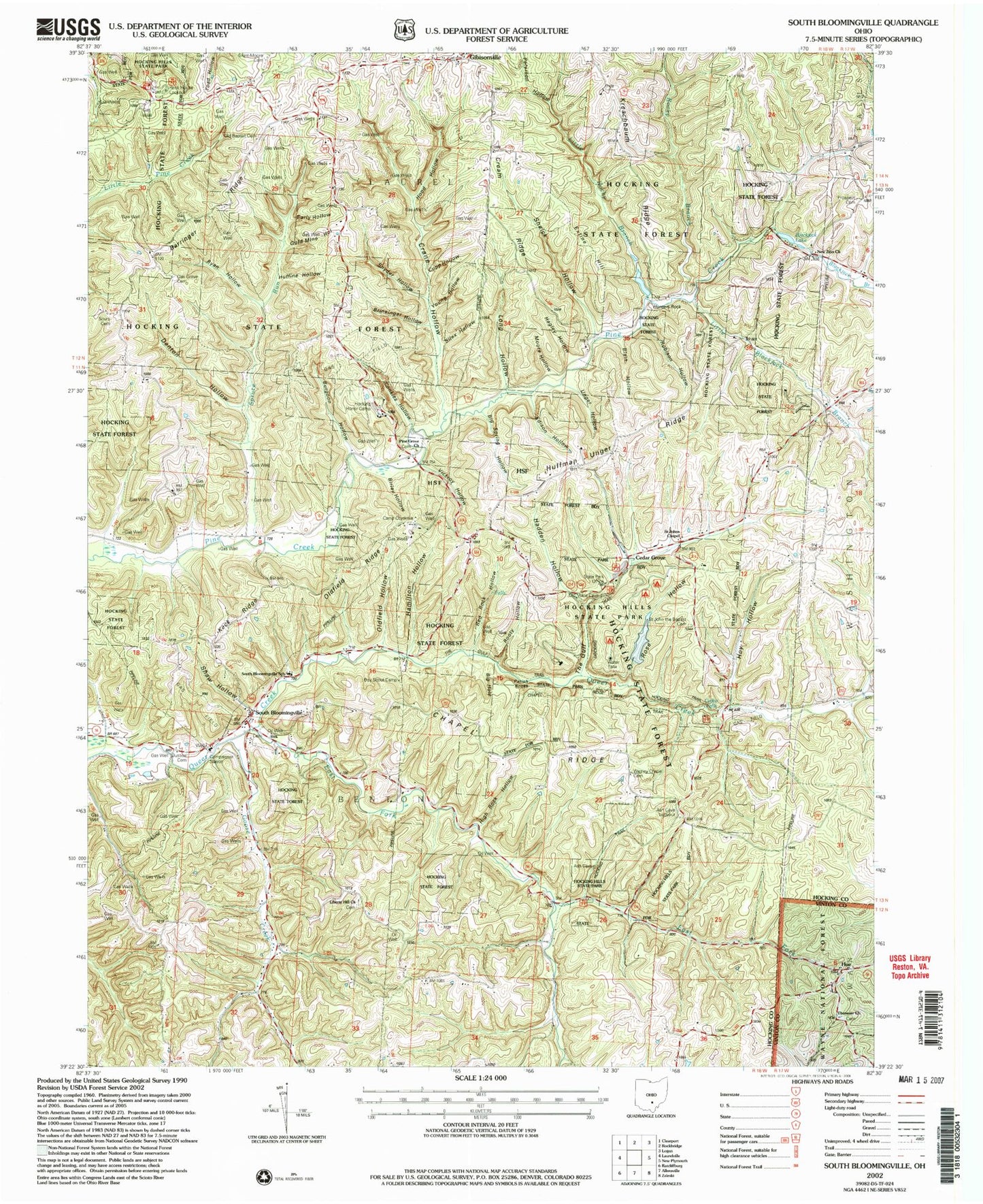
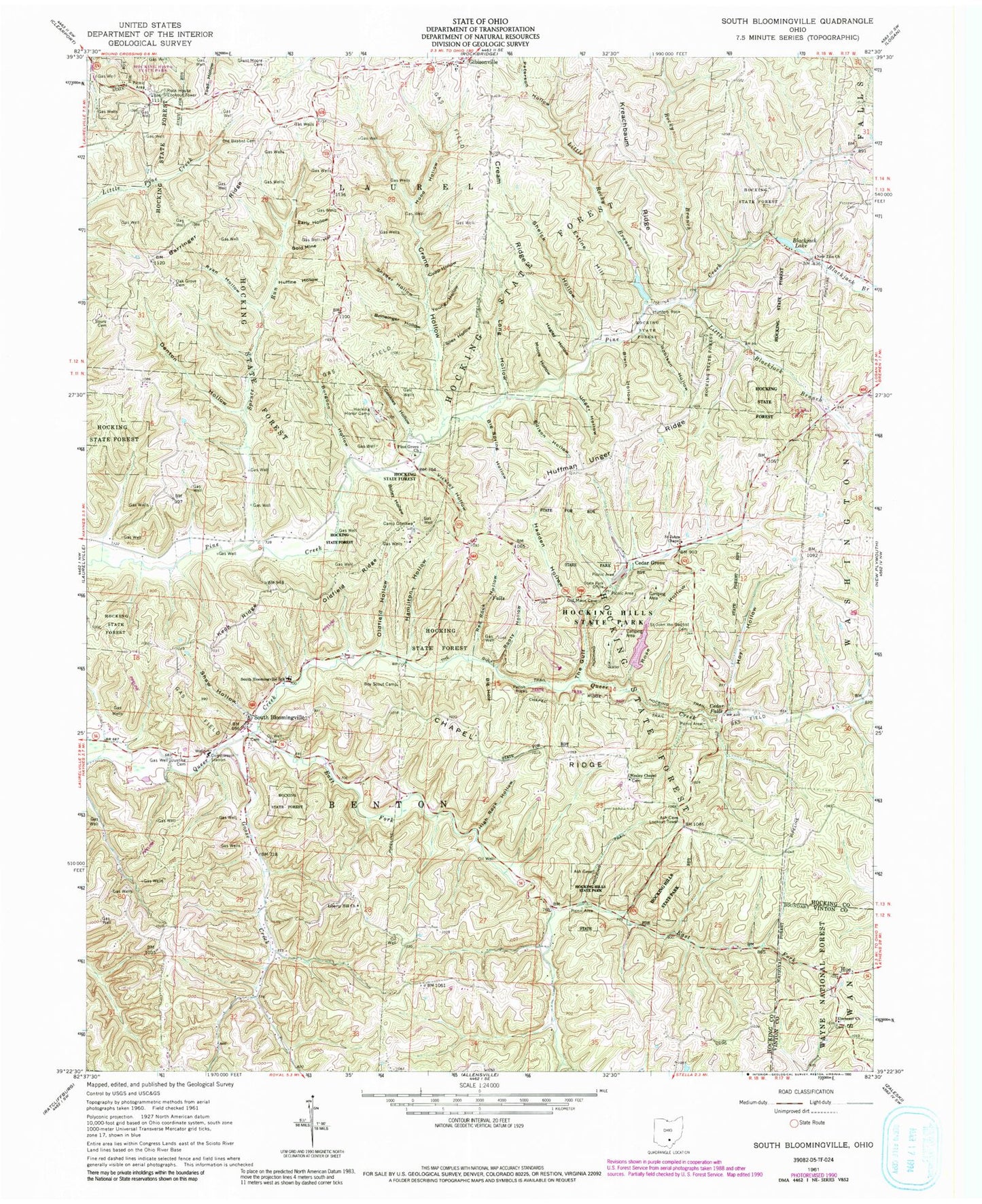
Classic USGS South Bloomingville Ohio 7.5'x7.5' Topo Map
Couldn't load pickup availability
Historical USGS topographic quad map of South Bloomingville in the state of Ohio. Typical map scale is 1:24,000, but may vary for certain years, if available. Print size: 24" x 27"
This quadrangle is in the following counties: Hocking, Vinton.
The map contains contour lines, roads, rivers, towns, and lakes. Printed on high-quality waterproof paper with UV fade-resistant inks, and shipped rolled.
Contains the following named places: Ebenezer School (historical), Rockhouse (historical), Cedar Falls (historical), Point Pleasant (historical), Pursell (historical), Barringer Ridge, Big Hole, Big Spring Hollow, Birley Hollow, Blackjack Branch, Blackjack Lake, Blain Hollow, Brineinger Hollow, Burgoon Hollow, Camp Otyokwa, Cedar Falls, Cedar Grove, Cedar Grove Trail, Chapel Ridge Trail, Conkles Hollow, Crane Hollow, Cream Ridge, Cupp Hollow, Denton Hollow, Early Hollow, East Fork Queer Creek, Ebenezer Church, Edison Hollow, Extine Hill, Gibisonville, Gold Mine Hollow, Goose Creek, Grant - Moore Cemetery, Hadden Hollow, Hagley Hollow, Hamilton Hollow, High Rock Hollow, Hocking State Forest, Hocking Honor Camp, Hocking Trail, Hood Hollow, Hoy Hollow, Hue, Huffine Hollow, Huffman Unger Ridge, Hunters Rock, Justice Cemetery, Keck Ridge, Kreachbaum Ridge, Liberty Hill Church, Little Blackjack Branch, Little Rocky Branch, Long Hollow, Moore Hollow, New Zion Church, Old Baptist Cemetery, Oldfield Hollow, Oldfield Ridge, Parish Rocks, Peterson Hollow, Pine Grove Church, Prospect Cemetery, Red Rock Hollow, Robison Hollow, Rocky Branch, Rooty Hollow, Rose Hollow, Ryan Hollow, Saint John the Baptist Cemetery, Saint Johns Chapel, Shaw Hollow, Sheick Hollow, Silex Hollow, Snyder Hollow, Sours Cemetery, South Bloomingville, Spruce Run, The Gulf, The Gulf Trail, Unger Hollow, Vickroy Hollow, Wesley Chapel, Young Hollow, Oak Grove Cemetery, Chapel Ridge, Hocking Hills Reservoir Dam, Hocking Hills Reservoir, Ash Cave Lookout Tower, Rock House Lookout Tower, South Bloomingville Elementary School, Conkles Hollow Recreation Area, Ash Cave Recreation Area, Hocking Hills State Park, Old Mans Cave Recreation Area, Conkles Hollow Picnic Area, Cedar Falls Picnic Area, Ash Cave Picnic Area, Township of Benton, Hagley Hollow Arch, Liberty Hill Cemetery, Brehm School (historical), Buchanan School (historical), Cream Ridge School (historical), Dresbach School (historical), Greenbrier School (historical), Oak Grove School (historical), Pine School (historical), Vorhees School (historical), Conkles Hollow State Nature Preserve, East Rim Trail, Gorge Trail, West Rim Trail, Ebenezer Cemetery, Methodist Episcopal Cemetery, Pine Grove Cemetery, South Bloomingville Cemetery, Wesley Chapel Cemetery, Cedar Grove Post Office (historical), Pursell Post Office (historical), Rockhouse Post Office (historical), South Bloomingville Post Office, Gibisonville Post Office (historical), Laurelville Fire Department Station 2