MyTopo
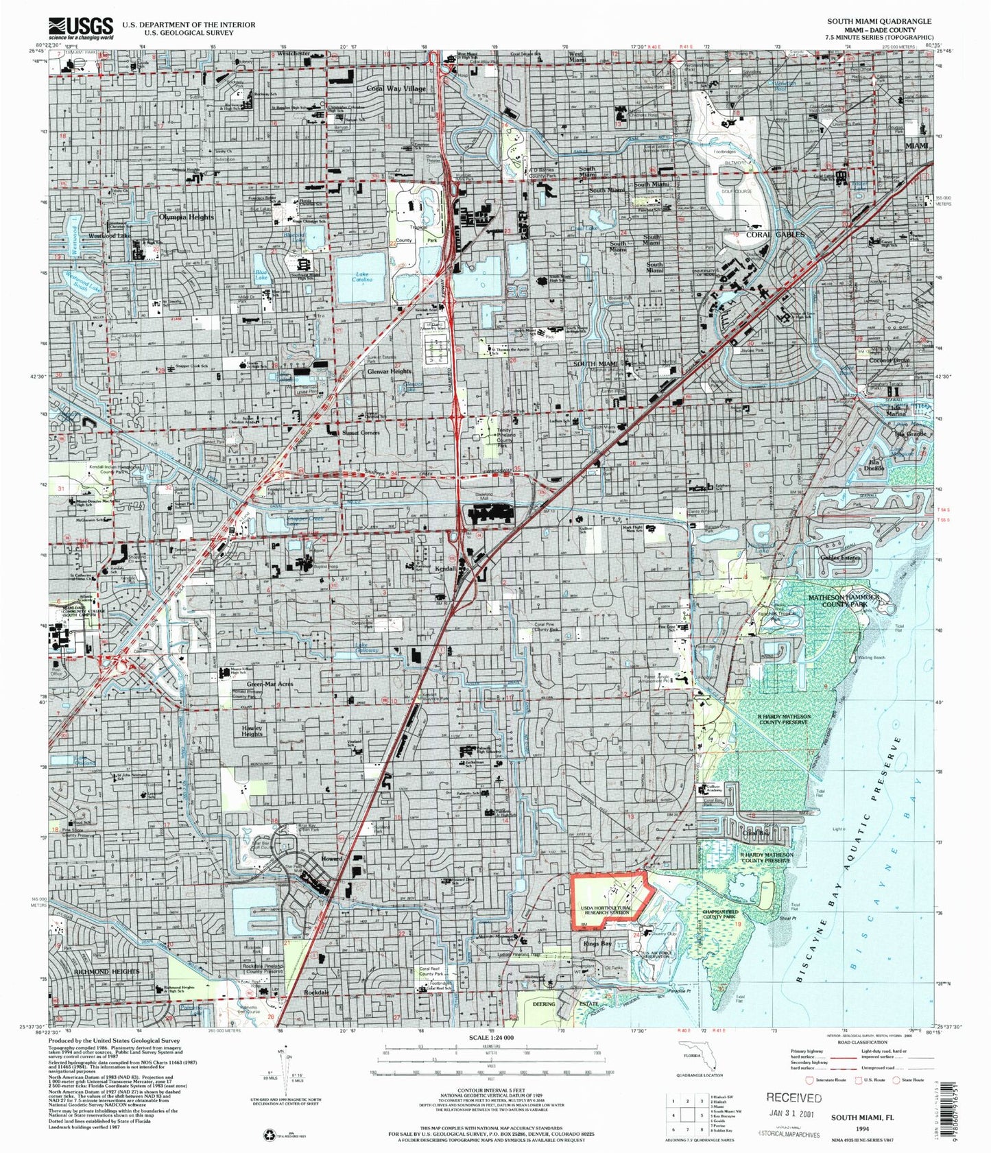
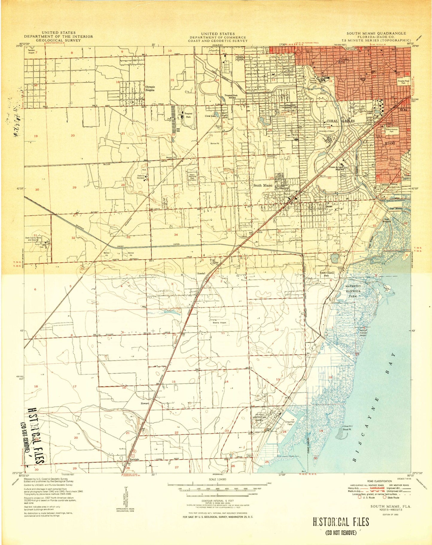
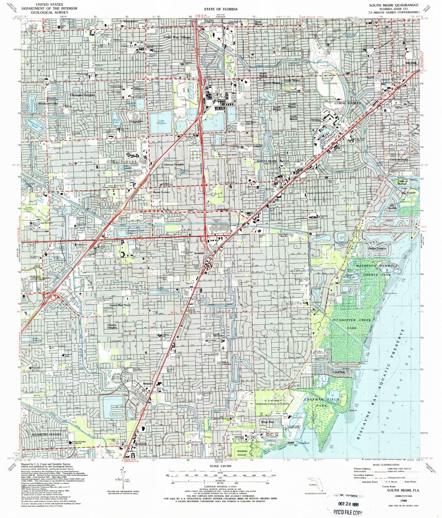
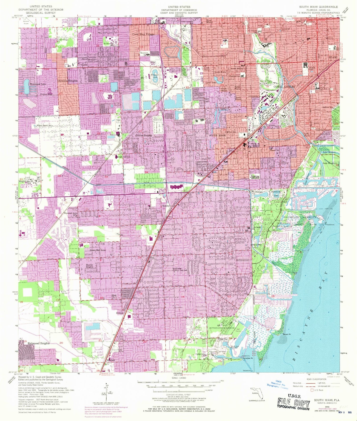
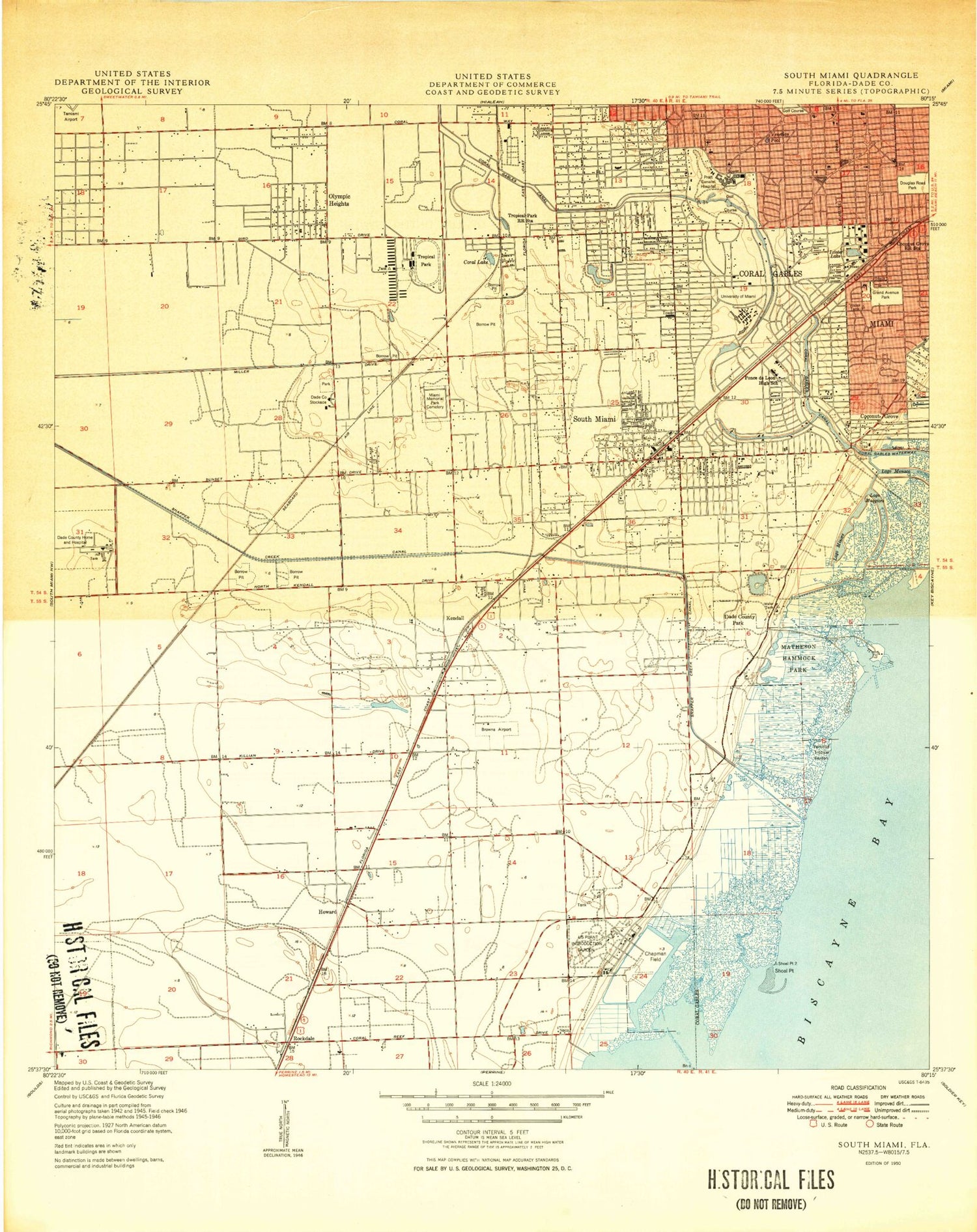
Classic USGS South Miami Florida 7.5'x7.5' Topo Map
Couldn't load pickup availability
Historical USGS topographic quad map of South Miami in the state of Florida. Map scale may vary for some years, but is generally around 1:24,000. Print size is approximately 24" x 27"
This quadrangle is in the following counties: Miami-Dade.
The map contains contour lines, roads, rivers, towns, and lakes. Printed on high-quality waterproof paper with UV fade-resistant inks, and shipped rolled.
Contains the following named places: 136th Street Plaza SW Shopping Center, 33143, 33146, 33155, 33156, 33158, 33165, 33173, 33176, 98th Avenue Shopping Center, A D Barnes County Park, A M I Kendall Regional Medical Center, Badeland Mall, Banyan Drive Park, Banyan Park, Baptist Hospital Heliport, Baptist Hospital of Miami, Biltmore Golf Course, Bird Drive Park, Bird Ludlam Shopping Center, Bird Road Shopping Center, Bird-Galloway Center, Blue Lake, Blue Lakes Park, Bluebird Lake, Bougainvillea School, Brewer Park, Briar Bay Golf Course, Briar Bay Urban Park, Broad Canal, Camp Floriday, Cartagena Plaza, Carver High School, Champions Club at Julington Creek, Chapman Field Park, Charlotte Jane Memorial Park Cemetery, Children's Center at Baptist Hospital of Miami, Cimarrone Golf Club, City of South Miami, Coconut Grove, Coconut Grove Station Railroad Station, Cocoplum Plaza, Cocoplum Yacht Club Marina, Colonial Palms Plaza, Colonial Palms Shopping Center, Continental Park, Coral 97th Plaza, Coral Bay Park, Coral Gables, Coral Gables Canal, Coral Gables Hospital, Coral Gables Waterway, Coral Gables Wayside Park, Coral Gables Youth Center, Coral Gate Shopping Center, Coral Lake, Coral Pine Park, Coral Reef Hospital, Coral Reef Park, Coral Terrace, Coral Terrace Census Designated Place, Coral Terrace School, Coral Way Park, Coral Way Shopping Center, Coral Way Shopping Plaza, Coral Way Village, Cutler Census Designated Place, Cutler Channel, Cutler Cove School, Cutler Drain Canal Number C-100, Cutler Drain Canal Number C-100 A, Cutler Drain Canal Number C-100 C, Dade School, Dadeland Mall, Dadeland North Station, Dadeland Plaza, Dadeland South Station, Dadeland Square, Dante B Fassell Park, David Fairchild Elementary School, Deering Bay, Deering Bay Yacht Club Marina, Deering Estate, Deerwood Town Center, Devonnaire Shopping Center, Doctors Hospital, Douglas Park, Douglas Road Station, Emerson Elementary School, Epiphany School, Fairchild Tropical Garden, Ferdinand Plaza, Florida Power and Light Cutler Steam Plant, Fuchs Park, Gables by the Sea, Gables Estates, Gifford Arboretum, Glenvar Heights, Glenvar Heights Census Designated Place, Glenvar Lake, Grand Avenue Park, Grapeland Heights Park, Green-Mar Acres, Grove Gate Shopping Center, Gulliver School, Hammock Lake, Hawley Heights, Howard, Humble Mini Park, I T T - Snapper Creek Park, Ingraham Terrace, Isla Dorada, Isla Grande, Isla Marina, Ixlater Lake, Jackson South Medical Center, Jaycee Park, Kendale Lakes Mall, Kendale Park, Kendall, Kendall Census Designated Place, Kendall Home Tract, Kendall Mall, Kendall Market Place Shopping Center, Kendall Town and Country Shopping Center, Kendall Wayside Park, Kendall-Palmetto Bay Division, Kendalwood Park, Keys Railroad Station, Kings Bay, Kings Bay Country Club, Kings Bay Shopping Center, K-Land Park, Lago Maggiore, Lago Minore, Lago Monaco, Lake Catalina, Lake Galloway, Lake Loladero, Lake Oakland, Larkin Community Hospital - South Miami Campus, Ludlam, Mahi Waterway, Marshall Williams Park, Matheson Hammock County Park, Matheson Hammock Marina, Merrick Park, Merrie Christmas Park, Miami Childrens Hospital, Miami Childrens Hospital Heliport, Miami Memorial Park Cemetery, Miami-Dade County Department of Youth and Family Development, Miller Drive Park, Miller Square, Mount Nebo Cemetery, Murray Park, Olympia Heights, Olympia Heights Census Designated Place, Olympia Heights Shopping Center, Palermo Park, Palmetto Golf Course, Palmetto Lake, Paradise Point, Parrot Jungle, Perrine Plaza, Pine Shore Park, Pinecrest, Pinelawn Memorial, Pioneer Park, Promenade Plaza, R Hardy Matheson County Preserve, Red Bird Shopping Center, Republic Lake, Richmond Heights, Richmond Heights Census Designated Place, Riviera Park, Rockdale, Rockdale Park, Rockland Pineland County Preserve, Rockway Park, Ronald Ehman Park, Saint James Golf Club, Salvadore Park, Schenly Park, Shoal Point, Shops at Sunset Place, Snapper Creek Lake, Snapper Creek Marina, Snapper Creek Park, South Miami, South Miami Hospital, South Miami Hospital Transitional Care Facility, South Miami Recreation Area, South Miami Shopping Center, South Miami Station, South Westside Division, Suniland, Suniland Park, Suniland Shopping Center, Sunkist Estates Park, Sunrise Park, Sunset, Sunset Census Designated Place, Sunset Corners, Sunset Park, Tamiami Park Stadium, The Crossings Shopping Center, The Falls Mall, Trinity Pineland County Park, Tropical Estates Park, Tropical Park, Tropical Park Railroad Station, Twin Lakes Canal, University Lake, University Park, University Park Census Designated Place, University Shopping Center, University Station, Venetian Pool, Village of Merrick Park, Village of Pinecrest, Village Square Plaza, Virrick Park, Water Plant Park, Westchester Census Designated Place, Westchester General Hospital, Westchester Mall, Westwood Lake, Westwood Lake South, Westwood Lakes Census Designated Place, WFBA-AM (Miami), WRHC-AM (Coral Gables), WVUM-FM (Coral Gables), Yacht Basin, Young Park