MyTopo
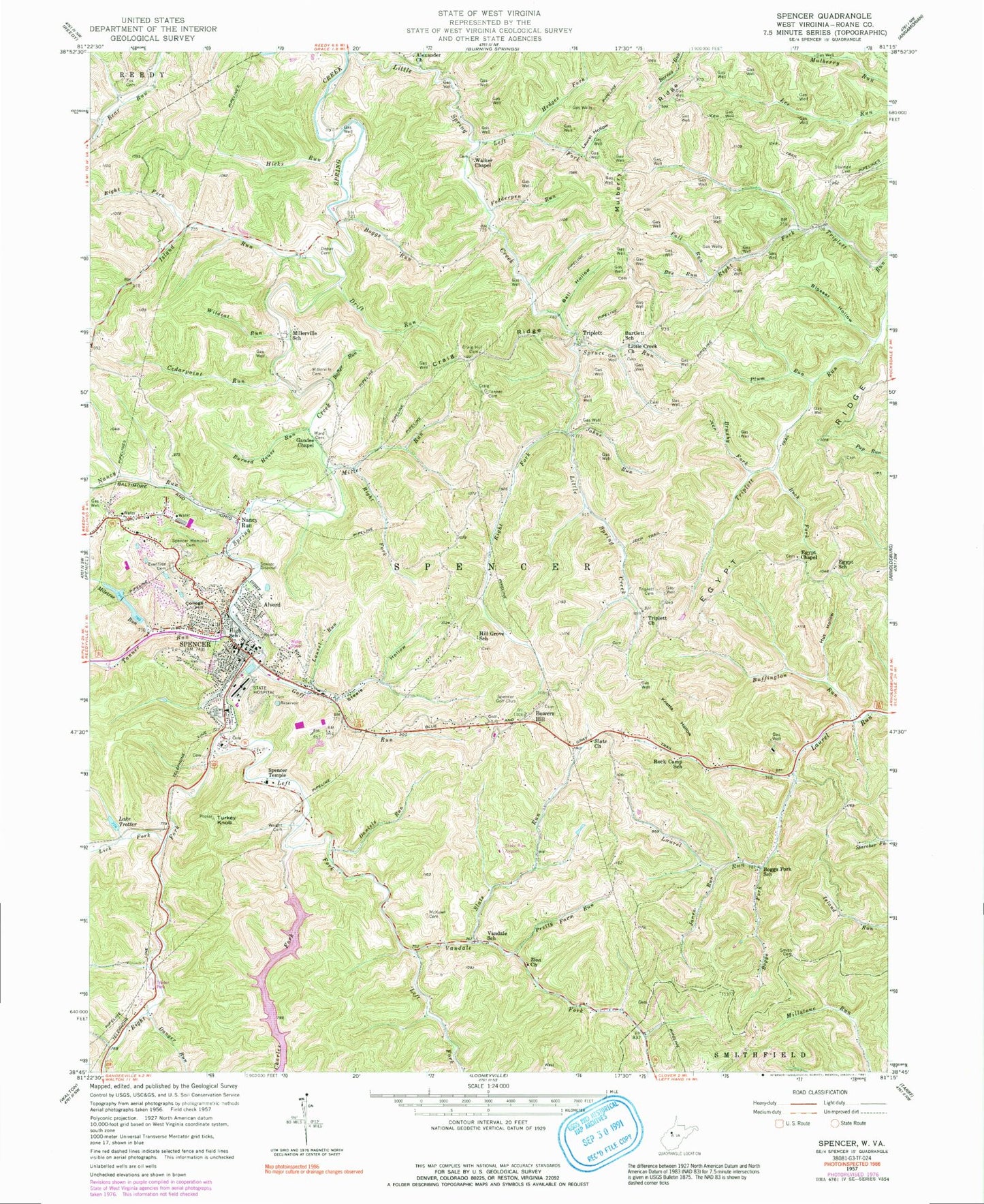
Classic USGS Spencer West Virginia 7.5'x7.5' Topo Map
Couldn't load pickup availability
Historical USGS topographic quad map of Spencer in the state of West Virginia. Map scale may vary for some years, but is generally around 1:24,000. Print size is approximately 24" x 27"
This quadrangle is in the following counties: Roane.
The map contains contour lines, roads, rivers, towns, and lakes. Printed on high-quality waterproof paper with UV fade-resistant inks, and shipped rolled.
Contains the following named places: Alexander Church, Alford Park, Alvord, Apostolic Faith Chapel, Ball Hollow, Bartlett Addition, Bartlett School, Bee Run, Blosser Hollow, Boggs Field, Boggs Fork, Boggs Fork Community Church, Boggs Fork School, Boggs Run, Bower Cemetery, Bowers Hill, Brushy Fork, Buffington Run, Burned House Run, Campbell Addition, Carmel School, Cedarpoint Run, Charles Fork, City of Spencer, College Hill, Craig Hill Cemetery, Craig Ridge, Danger Run, Daniels Run, Depue Cemetery, District II, Drift Run, East Meadows, Egypt Chapel United Methodist Church, Egypt Ridge, Egypt School, Eventide Cemetery, Fall Run, First Baptist Church of Spencer, Fodderpen Run, Fox Cemetery, Gandee Chapel, Goff Run, Graux, Green Acres, Hassock Addition, Hedges Fork, Hicks Run, Hill Grove School, Holswade Addition, Hut Hollow, Island Run, Janes Run, Johns Run, Knotts Hollow, Lake Trotter, Laurel Hollow, Laurel Run, Left Fork Little Spring Creek, Left Fork Spring Creek, Lick Fork, Little Creek Church, Love and Kindness Independent Church, Lower Vandal School, McKown Cemetery, Methodist Church Camp Lake Number Two Dam, Miletree Health Care Center, Miletree Lakes, Miletree Run, Miletree Run Dam Number One, Miletree Run Number Two Dam, Miller Run, Millerville Cemetery, Millerville School, Morford, Mulberry Ridge, Nancy Run, Northern District, Oak Grove School, Peters Cave Run, Peters Run School, Plum Run, Pretty Farm Run, Quiet Vale, Rafter Run, Right Fork Island Run, Right Fork Little Spring Creek, Right Fork Miller Run, Right Fork Spring Creek, Roane County Courthouse, Roane County Emergency Squad 700, Roane County Health Clinic, Roane County High School, Roane County Public Library, Roane County Sheriff's Office, Roane General Hospital, Rock Camp School, Rock Fork, Saint Johns United Methodist Church, Schilling, Schilling Addition, Schoolhouse Hill Addition, Slate Run, Slate Run Airport, Slate United Methodist Church, Smith Cemetery, Spencer, Spencer - Roane Volunteer Fire Department, Spencer Church of the Nazarene, Spencer Elementary School, Spencer Golf Club, Spencer High School, Spencer Memorial Cemetery, Spencer Middle School, Spencer Police Department, Spencer Post Office, Spencer State Hospital, Spencer Temple, Spring Creek-Charles Fork Number 17 Dam, Spruce Run, Stalman Cemetery, Steele Hollow, Steele Hollow Community Church, Tammany School, Tanner Cemetery, Tanner Run, Triplett, Triplett Cemetery, Triplett Church, Triplett School, Turkey Knob, Upper Vandal School, Vandale Fork, Vandale School, Veterans Memorial Bridge, Walker Chapel, Ward Cemetery, Washington Park, Wellington, West Virginia State Police Troop 4 - Spencer Detachment, Wildcat Run, Willow Bend School, Wright Cemetery, WVRC-AM (Spencer), Zion United Methodist Church, ZIP Code: 25276