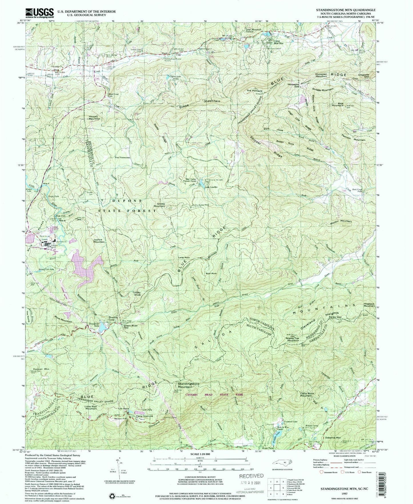
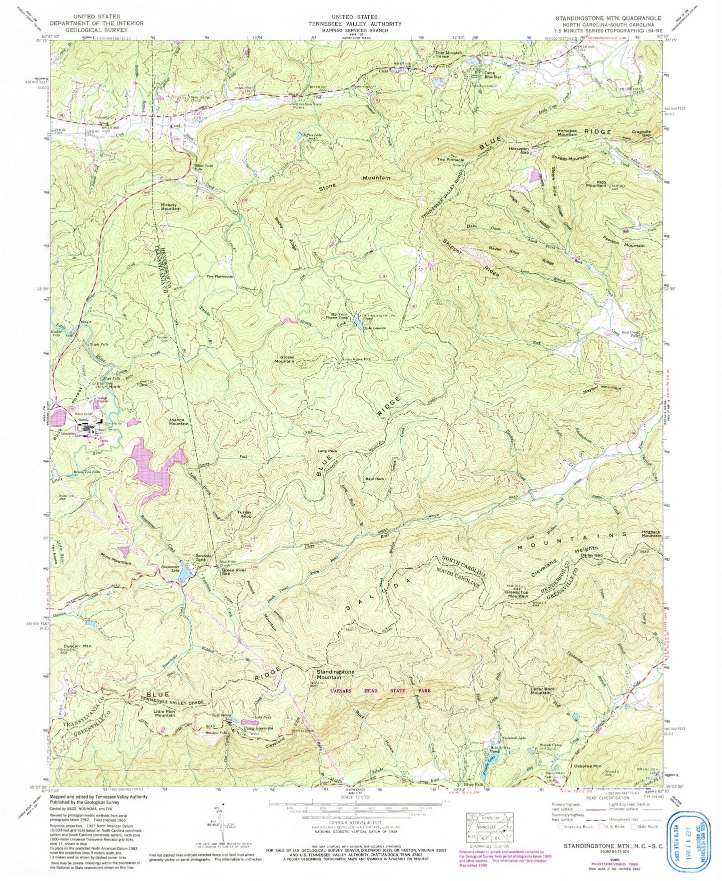
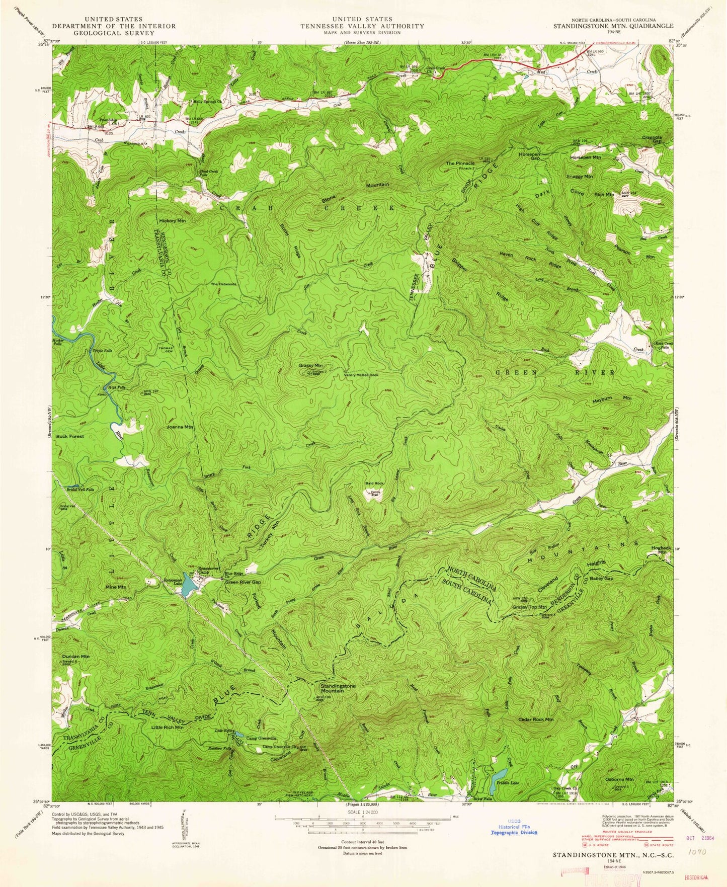
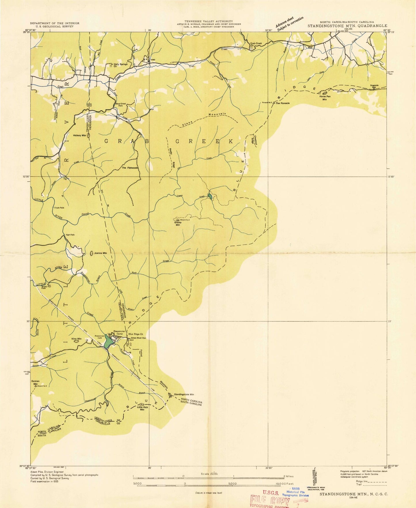
MyTopo
Classic USGS Standingstone Mountain South Carolina 7.5'x7.5' Topo Map
Couldn't load pickup availability
Historical USGS topographic quad map of Standingstone Mountain in the states of South Carolina, North Carolina. Typical map scale is 1:24,000, but may vary for certain years, if available. Print size: 24" x 27"
This quadrangle is in the following counties: Greenville, Henderson, Transylvania.
The map contains contour lines, roads, rivers, towns, and lakes. Printed on high-quality waterproof paper with UV fade-resistant inks, and shipped rolled.
Contains the following named places: Grassy Top Mountain, Hogback Mountain, Little Rich Mountain, Standingstone Mountain, Bluff Branch, Buck Hollow, Camp Greenville, Cherry Branch, Cleveland Cliff, Friddle Lake, Head Foremost Creek, Peters Branch, Rainbow Falls, Rocky Branch, Lake Rotary, Lake Sudy, Symmes Chapel, Tankersley Branch, Trammell Lake, Wabak Camp, Cedar Rock Mountain, South Carolina Noname 23019 D-2828 Dam, Sudy Lake Dam D-2826, Gap Creek Baptist Church Graveyard, Gap Creek School (historical), Hide-A-Way Camp, Little Falls Creek, Gap Creek Church, Osborne Mountain, WESC-FM (Greenville), Aaron Creek, Ailents Cove Branch, Bailey Gap, Bear Wallow Creek, Blue Ridge Church, Bridal Veil Falls, Camp Blue Star, Cleveland Heights, Crab Creek Church, Cragnola Gap, Dark Cove, Dismal Creek, Dry Branch, Dry Branch, Falls Creek, Friendship Church, Grassy Creek, Green River Gap, Hampy Creek, High Cliff Ridge, High Falls, Holly Springs Church, Holmes State Forest Nursery, Hooker Creek, Hooker Falls, Horsepen Gap, Jeffers Lake, Jim Branch, Jim Creek, Little Briery Creek, Little Cove Creek, Long Branch, Long Rock, Long Rock Branch, Lake Louellen, Meetinghouse Creek, Phillips Creek, Puncheon Creek, Raven Rock Ridge, Reasonover Creek, Reasonover Lake, Rich Mountain, Rock Creek Falls, Rocky Ridge, Saint Francis by the Lake Chapel, Shoal Branch, Shoal Creek, Shoal Creek Falls, Skipper Ridge, Sky Valley Pioneer Camp, Socareda Camp, Solomon Chapel, South Prong Green River, Steam Hole Ridge, Tarkiln Branch, The Flatwoods, The Nooks, Thomas Cemetery, Triple Falls, Uncles Creek, Vardry McBee Rock, Wildcat Branch, Reasonover Lake Dam, Summit Camp Lake, Summit Camp Lake Upper Dam, Summit Camp Lake Lower Dam, Summit Lake, Dupont Lake, Dupont Dam, Blue Star Upper Lake, Blue Star Upper Dam, Camp Blue Star Lake Number Two, Blue Star Lower Dam, Duncan Mountain, Little Creek, Swords Branch, Bald Rock, Big Laurel Creek, Briery Fork Creek, Bullings Creek, Forked Mountain, Grassy Mountain, Hickory Mountain, Horsepen Mountain, Jeter Mountain Terrace, Joanna Mountain, Maybin Mountain, Mine Mountain, North Prong Rock Creek, Pearson Mountain, Snaggy Mountain, Stone Mountain, The Pinnacle, Turkey Knob, Valley Hill Fire and Rescue Station 2, Grassy Top Mountain, Hogback Mountain, Little Rich Mountain, Standingstone Mountain, Bluff Branch, Buck Hollow, Camp Greenville, Cherry Branch, Cleveland Cliff, Friddle Lake, Head Foremost Creek, Peters Branch, Rainbow Falls, Rocky Branch, Lake Rotary, Lake Sudy, Symmes Chapel, Tankersley Branch, Trammell Lake, Wabak Camp, Cedar Rock Mountain, South Carolina Noname 23019 D-2828 Dam, Sudy Lake Dam D-2826, Gap Creek Baptist Church Graveyard, Gap Creek School (historical), Hide-A-Way Camp, Little Falls Creek, Gap Creek Church, Osborne Mountain, WESC-FM (Greenville), Aaron Creek, Ailents Cove Branch, Bailey Gap, Bear Wallow Creek, Blue Ridge Church, Bridal Veil Falls, Camp Blue Star, Cleveland Heights, Crab Creek Church, Cragnola Gap, Dark Cove, Dismal Creek, Dry Branch, Dry Branch, Falls Creek, Friendship Church, Grassy Creek, Green River Gap, Hampy Creek, High Cliff Ridge, High Falls, Holly Springs Church, Holmes State Forest Nursery, Hooker Creek, Hooker Falls, Horsepen Gap, Jeffers Lake, Jim Branch, Jim Creek, Little Briery Creek, Little Cove Creek, Long Branch, Long Rock, Long Rock Branch, Lake Louellen, Meetinghouse Creek, Phillips Creek, Puncheon Creek, Raven Rock Ridge, Reasonover Creek, Reasonover Lake, Rich Mountain, Rock Creek Falls, Rocky Ridge, Saint Francis by the Lake Chapel, Shoal Branch, Shoal Creek, Shoal Creek Falls, Skipper Ridge, Sky Valley Pioneer Camp, Socareda Camp, Solomon Chapel, South Prong Green River, Steam Hole Ridge, Tarkiln Branch, The Flatwoods, The Nooks, Thomas Cemetery, Triple Falls, Uncles Creek, Vardry McBee Rock, Wildcat Branch, Reasonover Lake Dam, Summit Camp Lake, Summit Camp Lake Upper Dam, Summit Camp Lake Lower Dam, Summit Lake, Dupont Lake, Dupont Dam, Blue Star Upper Lake, Blue Star Upper Dam, Camp Blue Star Lake Number Two, Blue Star Lower Dam, Duncan Mountain, Little Creek, Swords Branch, Bald Rock, Big Laurel Creek, Briery Fork Creek, Bullings Creek, Forked Mountain