
MyTopo
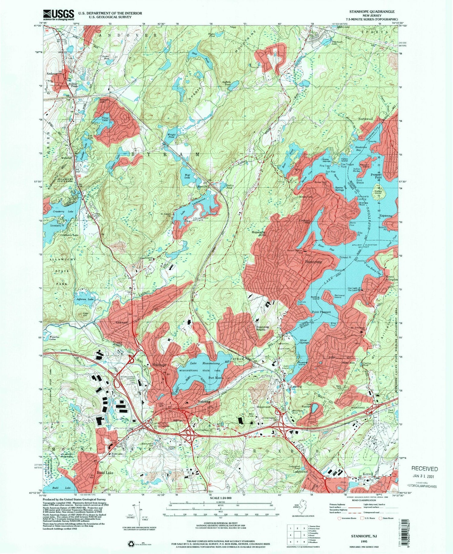
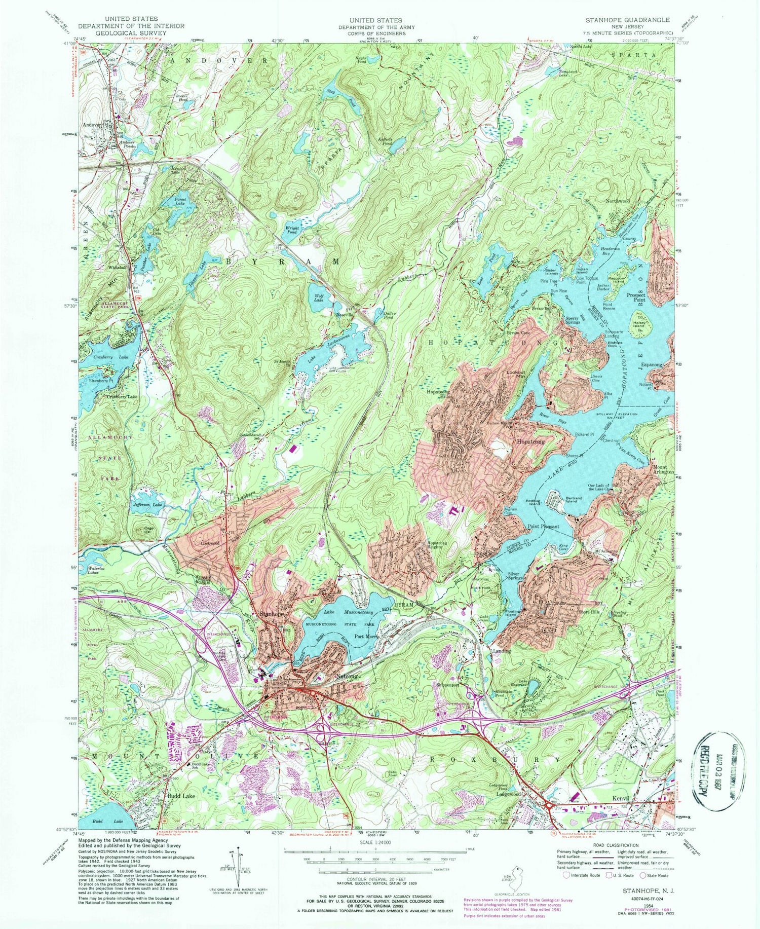
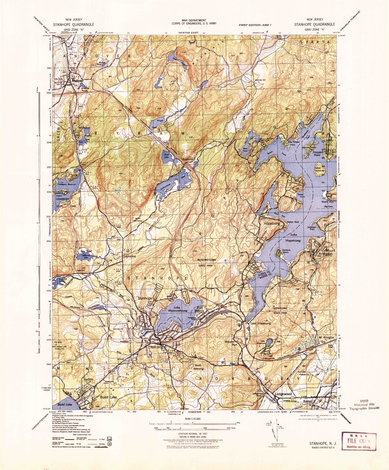
Classic USGS Stanhope New Jersey 7.5'x7.5' Topo Map
Couldn't load pickup availability
Historical USGS topographic quad map of Stanhope in the state of New Jersey. Typical map scale is 1:24,000, but may vary for certain years, if available. Print size: 24" x 27"
This quadrangle is in the following counties: Morris, Sussex.
The map contains contour lines, roads, rivers, towns, and lakes. Printed on high-quality waterproof paper with UV fade-resistant inks, and shipped rolled.
Contains the following named places: Andover, Andover Ponds, Mount Arlington, Bear Pond, Bedbug Island, Bertrand Island, Bishops Rock, Bonaparte Landing, Budd Lake School, Byram Bay, Byram Bay Church, Byram Cove, Byram Cove, Cage Hill, Chestnut Point, County Island, Cow Tongue Point, Cranberry Lake, Cranberry Lake, Allamuchy State Park, Cub Lake, Dallis Pond, Davis Cove, Dunlap Pond, Elba Point, Floating Island, Forest Lake, Great Cove, Halsey Island, Hemlock Lake, Henderson Bay, Henderson Cove, Hopatcong, Hopatcong Heights, Hopatcong Hills, Hopatcong State Park, Lake Hopatcong, Hudson Maxim Elementary School, Hughs Pond, Indian Harbor, Indian Island, Ingram Cove, Jayness Brook, Jefferson Lake, Johnson Lake, King Cove, Kofferls Pond, Lake Lackawanna, Landing, Ledgewood, Ledgewood Pond, Lockwood, Lookout Mountain, Lake Louise, Lubbers Run, Mount Arlington, Mount Arlington Public Elementary School, Mountain Brook, Musconetcong State Park, Lake Musconetcong, Netcong, Nolans Point, Northwood, Our Lady of the Lake Church, Panther Lake, Pickerel Point, Pine Tree Point, Point Breeze, Point Pleasant, Port Morris, Prospect Point, Raccoon Island, River Styx, Rocker Pond, Lake Rogerene, Roseville, Saint Joseph Church, Sharps Point, Shippenport, Shore Hills, Silver Springs, Sister Islands, Sperry Springs, Stag Pond, Stanhope, Stanhope Union Cemetery, Strawberry Point, Sun Rise Point, Tomahawk Lake, Van Every Cove, Whitehall, Wills Brook, Wolf Lake, Wright Pond, Mountain Pond, Andover Junction, Township of Roxbury, Township of Byram, Jefferson Lake Dam, Cranberry Lake Dam, Forest Lake Dam, Johnson Lake Dam, Hemlock Lake Dam, Kofferls Pond Dam, Tomahawk Lake Dam, Lake Lackawanna Dam, Lake Hopatcong Dam, Lake Musconetcong Dam, Lake Lackawanna Golf Course, Westby Heliport, Trade Zone Heliport, Fla-Net Airport (historical), Borough of Andover, Borough of Hopatcong, Borough of Mount Arlington, Borough of Netcong, Borough of Stanhope, Punkhorn Creek, Budd Lake State Wildlife Management Area, Consolidated School, South Netcong, Port Morris School (historical), International Trade Center, Lee's County Park, Netcong Elementary School, Andover School (historical), Byram Township Intermediate Elementary School, Durban Avenue Elementary School, Hopatcong High School, Hopatcong Middle School, Lenape Valley Regional High School, Linden Avenue Elementary School, Tulsa Trail Elementary School, Valley Road Elementary School, Cowboy Creek, Ghost Pony Brook, Netcong Circle, Bertrand Island Amusement Park (historical), Byram Quarry, Byram Center Census Designated Place, Hopatcong Fire Department, Lake Rogerene Fire Department, Mount Arlington Fire Department, Roxbury Township Fire Prevention Bureau, Andover Borough Fire Department, Hopatcong Fire Department Defiance Engine Company 3, Hopatcong Fire Department, Byram Township Fire Department Station 3, Byram Township Fire Department Station 2, Hill Top Fire Company 2, Roxbury Fire Coumpany 2 Annex, Netcong Fire Department Company 1, New Jersey Forest Fire Service North Division, Stanhope Fire Department, Byram Township Volunteer Fire Department, Lakeland Emergency Squad, Mount Arlington Rescue Squad, Stanhope - Netcong American Legion Ambulance, Atlantic Air Ambulance, Hopatcong Ambulance Squad, Landing Quarry, Byram Township Police Department, Stanhope Borough Police Department, Hopatcong Police Department, Netcong Borough Police Department, Mount Arlington Police Department, Roxbury Township Police Department, New Jersey State Police Station, Glasser Post Office, Landing Post Office, Hopatcong Post Office, Mount Arlington Post Office, Andover Post Office, Ledgewood Post Office, Kenvil Post Office, Netcong Post Office, Stanhope Post Office, Landing Census Designated Place, Ledgewood Census Designated Place, Port Morris Census Designated Place, Andover, Andover Ponds, Mount Arlington, Bear Pond, Bedbug Island, Bertrand Island, Bishops Rock, Bonaparte Landing, Budd Lake School, Byram Bay, Byram Bay Church, Byram Cove, Byram Cove, Cage Hill, Chestnut Point, County Island, Cow Tongue Point, Cranberry Lake, Cranberry Lake, Allamuchy State Park, Cub Lake, Dallis Pond, Davis Cove, Dunlap Pond, Elba Point, Floating Island, Forest Lake, Great Cove, Halsey Island, Hemlock Lake, Henderson Bay, Henderson Cove, Hopatcong, Hopatcong Heights, Hopatcong Hills, Hopatcong State Park, Lake Hopatcong, Hudson Maxim Elementary School, Hughs Pond, Indian Harbor, Indian Island, Ingram Cove, Jayness Brook, Jefferson Lake, Johnson Lake, King Cove, Kofferls Pond, Lake Lackawanna, Landing, Ledgewood, Ledgewood Pond, Lockwood, Lookout Mountain, Lake Louise, Lubbers Run, Mount Arlington


