MyTopo
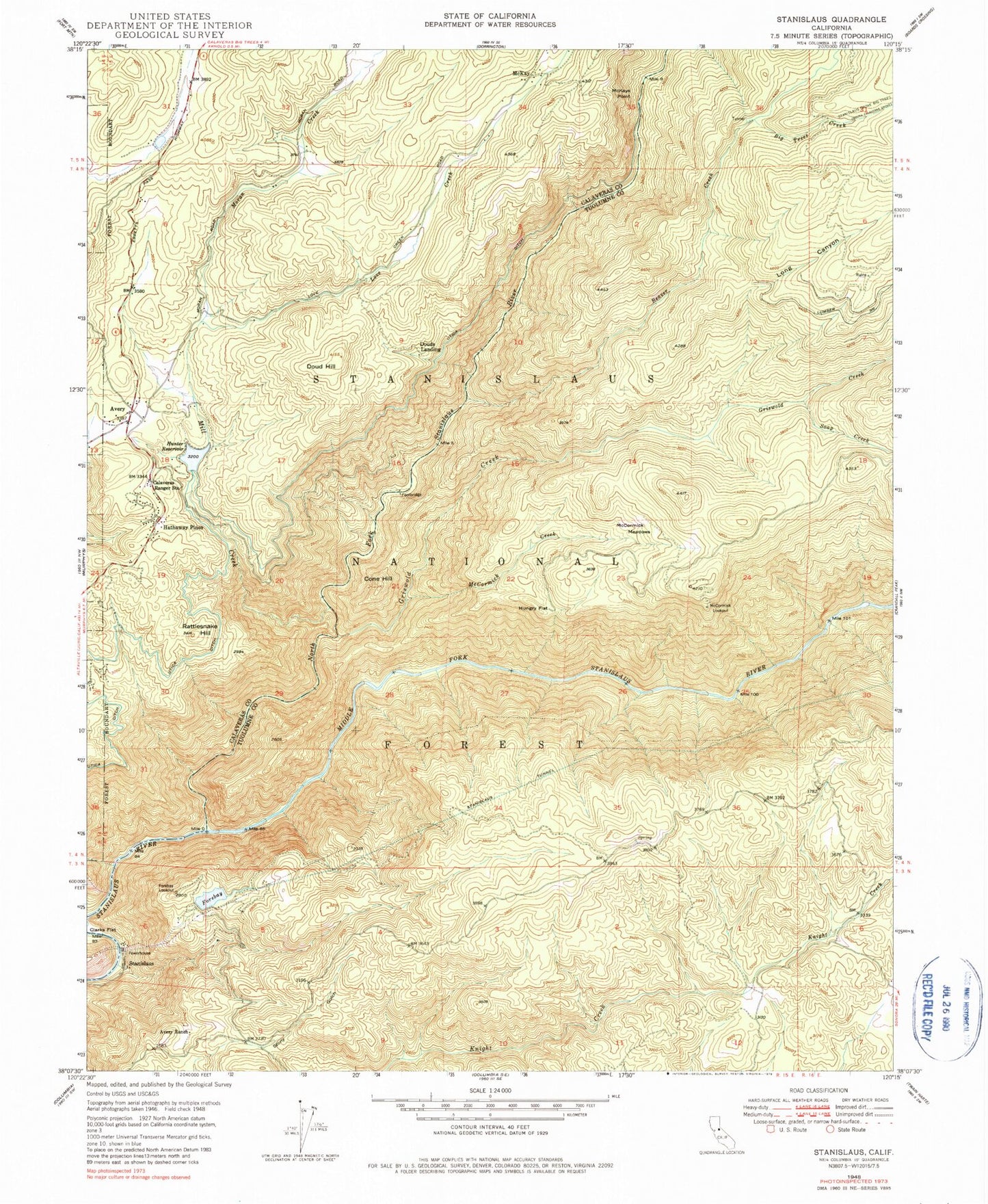
Classic USGS Stanislaus California 7.5'x7.5' Topo Map
Couldn't load pickup availability
Historical USGS topographic quad map of Stanislaus in the state of California. Typical map scale is 1:24,000, but may vary for certain years, if available. Print size: 24" x 27"
This quadrangle is in the following counties: Calaveras, Tuolumne.
The map contains contour lines, roads, rivers, towns, and lakes. Printed on high-quality waterproof paper with UV fade-resistant inks, and shipped rolled.
Contains the following named places: Avery, Avery Ranch, Big Trees Creek, Calaveras Ranger Station, Cone Hill, Doud Hill, Forebay Lookout, Griswold Creek, Hungry Flat, Hunter Reservoir, Long Canyon, McCormick Creek, McCormick Lookout, McCormick Meadows, McKays Point, Mill Creek, Rattlesnake Hill, Stanislaus Grove Big Trees, Beaver Creek, Love Creek, Moran Creek, North Fork Stanislaus River, Soap Creek, Stanislaus Tunnel, Sugar Pine Gap, Utica Ditch, Clark Flat, Wisehart Pit, Calaveras District Ranger Office, Crescent Cove Campground, Fly in Acres Reservoir, Pinebrook Reservoir, Arnold California Division of Forestry Fire Station, Crescent Cove Picnic Area, Candy Rock, Hunter Reservoir Heliport, Douds Landing, Hathaway Pines, McKay, Stanislaus, Stanislaus Forebay 97-083 Dam, Hunters 99-002 Dam, Fly in Acres 503 Dam, Avery Post Office, Canyon View, Hathaways Mountain Pines, Ponderosa Park, Sunset Point, Camp Forty-Niner, Ebbetts Pass Highlands, Lakemont Pines, Leach Field, Meadowmont, Pinebrook, Saint Claires Episcopal Church, Fly-In Acres, Arnold Census Designated Place, Avery Census Designated Place, Ebbetts Pass Fire Protection District Station 3, Ebbetts Pass Fire Protection District Station 4, Department of Forestry and Fire Protection Arnold Station, Department of Forestry and Fire Protection Arnold Fire Station, Hathaway Pines Post Office, Avery, Avery Ranch, Big Trees Creek, Calaveras Ranger Station, Cone Hill, Doud Hill, Forebay Lookout, Griswold Creek, Hungry Flat, Hunter Reservoir, Long Canyon, McCormick Creek, McCormick Lookout, McCormick Meadows, McKays Point, Mill Creek, Rattlesnake Hill, Stanislaus Grove Big Trees, Beaver Creek, Love Creek, Moran Creek, North Fork Stanislaus River, Soap Creek, Stanislaus Tunnel, Sugar Pine Gap, Utica Ditch, Clark Flat, Wisehart Pit, Calaveras District Ranger Office, Crescent Cove Campground, Fly in Acres Reservoir, Pinebrook Reservoir, Arnold California Division of Forestry Fire Station, Crescent Cove Picnic Area, Candy Rock, Hunter Reservoir Heliport, Douds Landing, Hathaway Pines, McKay, Stanislaus, Stanislaus Forebay 97-083 Dam, Hunters 99-002 Dam, Fly in Acres 503 Dam, Avery Post Office, Canyon View, Hathaways Mountain Pines, Ponderosa Park, Sunset Point, Camp Forty-Niner, Ebbetts Pass Highlands, Lakemont Pines, Leach Field, Meadowmont, Pinebrook, Saint Claires Episcopal Church, Fly-In Acres, Arnold Census Designated Place, Avery Census Designated Place, Ebbetts Pass Fire Protection District Station 3, Ebbetts Pass Fire Protection District Station 4, Department of Forestry and Fire Protection Arnold Station, Department of Forestry and Fire Protection Arnold Fire Station, Hathaway Pines Post Office