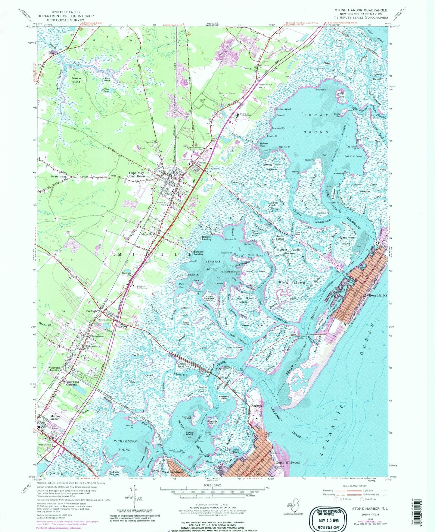
MyTopo
Classic USGS Stone Harbor New Jersey 7.5'x7.5' Topo Map
Couldn't load pickup availability
Historical USGS topographic quad map of Stone Harbor in the state of New Jersey. Typical map scale is 1:24,000, but may vary for certain years, if available. Print size: 24" x 27"
This quadrangle is in the following counties: Cape May.
The map contains contour lines, roads, rivers, towns, and lakes. Printed on high-quality waterproof paper with UV fade-resistant inks, and shipped rolled.
Contains the following named places: Gull Island Thorofare, Cape May County Park, Aaron Denny Creek, Anglesea, Anglesea Island, Anglesea Marsh, Back Creek, Back o' th' Sound, Balson Point, Beach Creek, Bennys Landing, Bluefish Brothers, Ring Island Creek, Brothers Creek, Buck Island, Burleigh, Burleigh Church, Cape May Court House, Carino Creek, Carnival Bay, Cat Run, Charles Creek, Clubhouse Creek, Coover Island, Cresse Creek, Cresse Thorofare, Cresthaven County Home, Crooked Creek, Crooked Thorofare, Crooked Thorofare Cove, Dead Thorofare, Dead Thorofare Point, Deep Creek, Deep Thorofare, Devils Wedge, Drum Creek, Drum Island, Drum Thorofare, Dung Thorofare, Fairview Memorial Cemetery, Firman Island, Stone Harbor Bird Sanctuary, Gar Creek, Genesis Bay, Go Through Creek, Go Through Gut, Grassy Point, Grassy Sound, Grassy Sound, Grassy Sound Channel, Grassy Sound Meadow, Gravelly Run, Great Channel, Great Flat, Great Flat Thorofare, Great Sound, Gull Island, Gunners Point, Halfmile Point, Halfmile Point Meadow, Hammock Creek, Hann Cove, Hann Point, Harbor Canal, Haulover Point, Hereford Inlet, Herring Point, Hetty Creek, Hoffman Canal, Holmes Cove, Holmes Creek, Inner Point, Island Thorofare, Jacovy Creek, Jenkins Channel, Jenkins Point, Jenkins Sound, Jimmys Point, Josh Creek, Jug Creek, Leonard Thorofare, Little Dung Thorofare, Little Oyster Creek, Little Scotch Bonnet, Little Snake Hill, Little Sound Meadow, Little Turtle Gut, Lower Long Reach, Ludlum Gut, Ludlum Pond, Marlyn Manor, Mayville, Middle Thorofare, Middle Thorofare Island, Miller Pond (historical), Mommy Teel Creek, Mud Creek, Muddy Hole, Muddy Hole Island, Mulford Creek, Mulford Creek Meadow, Nancys Bridge, Narrows Point, Nichols Channel, Nichols Point, No Mans Island, North Channel, North Channel Pond, North Point, North Wildwood, Nummy Island, Old Turtle Point, Old Turtle Point, Old Turtle Reach, Old Turtle Thorofare, Oldman Creek Meadow, Ottens Basin, Ottens Canal, Outer Island, Oyster Creek, Oyster Creek, Oyster Creek Point, Paddy Bar, Paddy Thorofare, Phillip Shields Islands, Pleasure Bay, Poor House Flat, Potato Island, Powells Point, Race Cove, Rachael Point, Rachel Gut, Reubens Wharf, Richardson Sound, Ring Island, Saint Stevens Church, Salt Creek, Sand Marsh, Sand Marsh Cove, Scotch Bonnet, Scotch Bonnet, Scotch Bonnet Bridge, Second Church, Sedge Island, Shark Creek, Shellbed Creek, Shellbed Landing, Shelter Haven, Shooting Island, Side o' th' Bay, Skeeter Island, Skeeter Island Creek, Slaughter Gut, Snug Harbor, South Basin, South Creek, Southeast Creek, Southeast Point, Stone Harbor, Stone Harbor, Stone Harbor Bridge, Stone Harbor Creek, Stone Harbor Hole, Sturgeon Hole, Sturgeon Island, Sturgeon Point, Sugar Farm Creek, Swain Point, Taugh Creek, Taugh Point, Tempe Creek, Through Creek, Through Creek, Tick Neck, Townsend Point, Turtle Gut, Upper Island, Warren Point, West Fork Oldman Creek, West Island, West Wildwood, White Island, White Island Point, Whitesboro, Wildwood Canal, Wildwood Gardens, Wildwood Junction, Wishbone Island, Township of Middle, Cape May County, Beach Creek Meadow, Beach Creek Point, Bluefish Creek, Champagne Island, Crooked Thorofare Point, Crookhorn Creek, Drum Island Gut, Goth Creek, Go Through Thorofare, Mat Gut, Mud Creek Point, North Basin, Nummy Island Creek, Oldman Creek, Rachael Creek, S Creek, Seven Mile Point, Slab Creek, Stone Harbor Canal, Voorhees Creek, Bristol Range, Little Sound, Sanctuary Bay, Paradise Bay, Stone Harbor Manor, Wildwood Golf Course, Ike's Point, WCMC-AM (Wildwood), WSJL-FM (Cape May), WLQE-FM (Villas), WZXL-FM (Wildwood), WMGM-TV (Wildwood), Stone Harbor Golf Club Heliport, City of North Wildwood, Borough of Stone Harbor, Borough of West Wildwood, Ocean Academy School, Stone Harbor Elementary School, Middle Township High School, Middle Township 1 Elementary School, Cape Christian Academy Elementary School, Cape May County Evening High and Vocational School, Middle Township 2 Elementary School, Lillian Whitfield Seveth Day Adventist School, Cape May County Technical High School, Cape May County Alternative High School