MyTopo
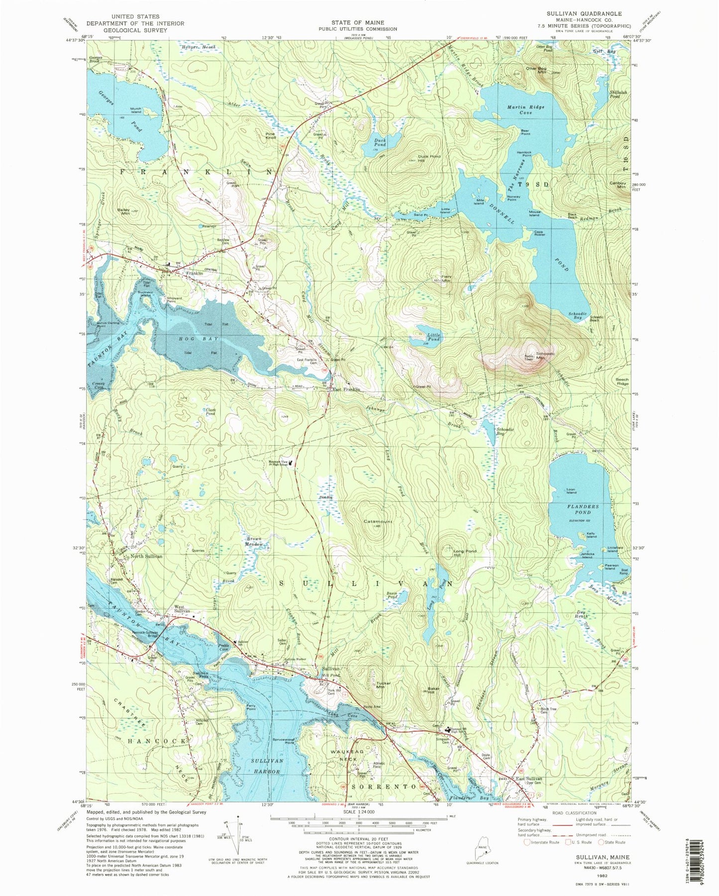
Classic USGS Sullivan Maine 7.5'x7.5' Topo Map
Couldn't load pickup availability
Historical USGS topographic quad map of Sullivan in the state of Maine. Typical map scale is 1:24,000, but may vary for certain years, if available. Print size: 24" x 27"
This quadrangle is in the following counties: Hancock.
The map contains contour lines, roads, rivers, towns, and lakes. Printed on high-quality waterproof paper with UV fade-resistant inks, and shipped rolled.
Contains the following named places: Alder Brook, Baker Hill, Basin Pond, Bayview Cemetery, Birch Tree Cemetery, Buckskin Camp, Card Mill Stream, Clark Pond, Donnell Pond, Duck Pond, Duck Pond Hill, East Franklin, East Sullivan, Falls Point, Ferry Point, Fiery Mountain, Flanders Pond, Flanders Stream, Franklin, Georges Pond, Gill Bog, Hemlock Point, Hillcrest Cemetery, Hog Bay, Little Pond, Long Cove, Long Pond, Long Pond Hill, Martin Ridge Brook, Martin Ridge Cove, North Sullivan, Norway Point, Otter Bog Mountain, Pine Knoll, Preble Cove, Schoodic Bay, Schoodic Bog, Schoodic Mountain, Schoodic Nubble, Shillalah Pond, Sullivan, Sullivan Falls, Sumner Cemetery, Sumner Memorial High School, Swan Brook, Taunton Bay, Tucker Mountain, Union Church, Waukeag, West Sullivan, York Hill Cemetery, Evergreen Point, Schoodic, Simpson Cemetery, Sprucewood Point, Dyer Cemetery, Smelt Cove, Smelt Brook, Clapham Brook, Doyle Cemetery, Sullivan School, Hancock-Sullivan Bridge, Grays Brook, Mill Brook, Salter Cemetery, Sullivan Harbor School, Dry Heath, Dry Brook, Mill Pond, Brown Meadow, Blaisdell Cemetery, Gordon Cemetery, Littlefield Island, Pearson Island, Catamount, Loon Island, Kelly Island, Jehlickoo Island, Johnnys Brook, Rocky Brook, Mountain View School, East Franklin Cemetery, Long Pond Brook, Schoodic Brook, Shipyard Point, Buckskin Island, Julius Darling Point, Bailey Mountain, Cape Rosier, Schoodic Beach, Mile Island, Little Island, Sand Point, Bear Point, The Narrows, Black Beach, Murch Island, Redman Brook, Springer Creek, Town of Franklin, Town of Sullivan, Donnell Pond Dam, Bean Meadow, Creasy Cove, Franklin Baptist Church, Franklin Historical Society Building, Franklin Post Office, Franklin United Methodist Church, Mountainview Campground, Mouse Island, North Sullivan United Methodist Church, Sullivan Harbor Church, Sullivan Harbor Scenic Turnout, Sullivan Post Office, Sullivan-Sorrento Historical Society Building, Sullivan Volunteer Fire Department, Sullivan Volunteer Fire Department East Sullivan Station, Franklin Volunteer Fire Department, Urann Cemetery, Frenchman's Bay Library, T9 SD BPP