MyTopo
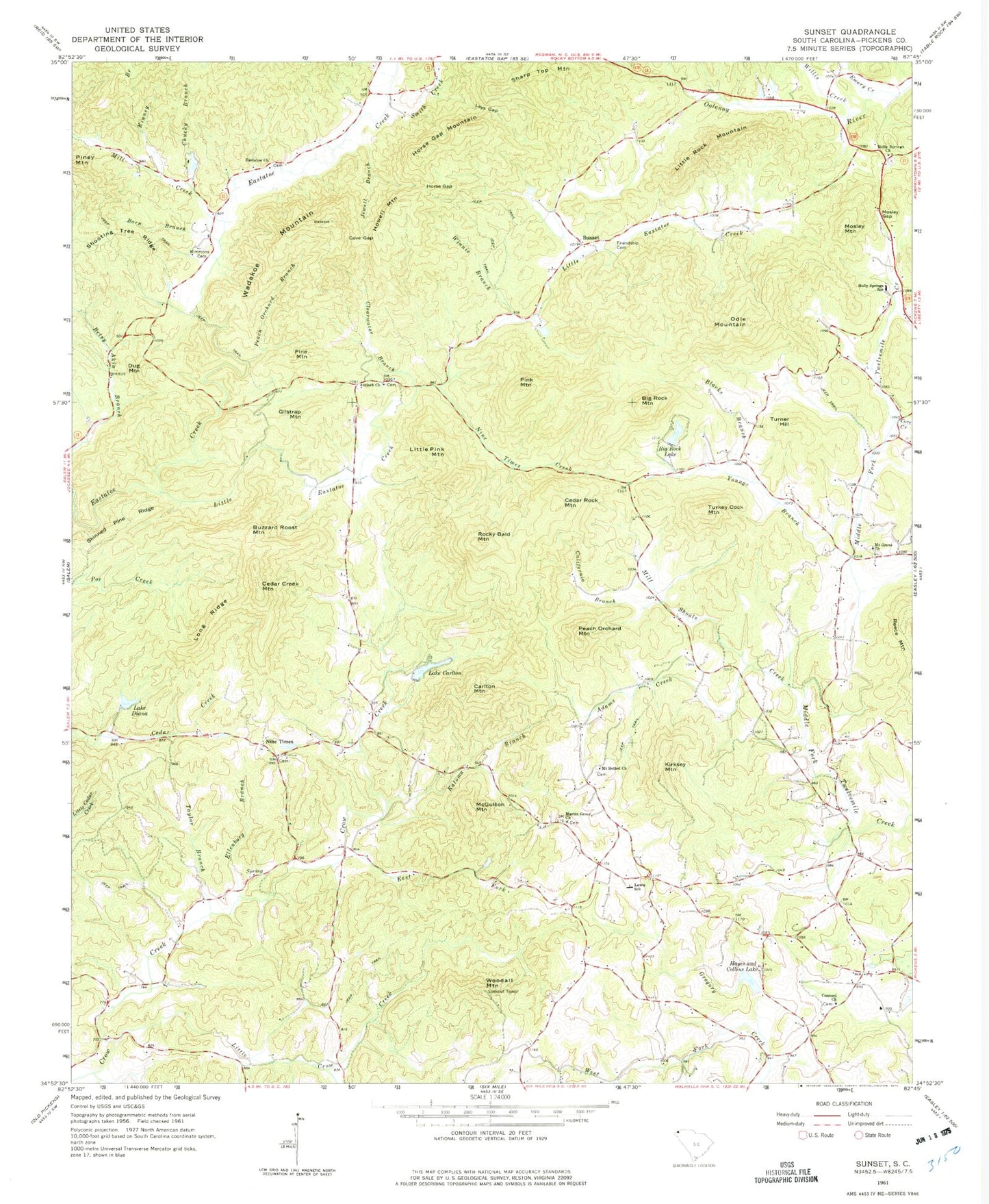
Classic USGS Sunset South Carolina 7.5'x7.5' Topo Map
Couldn't load pickup availability
Historical USGS topographic quad map of Sunset in the state of South Carolina. Typical map scale is 1:24,000, but may vary for certain years, if available. Print size: 24" x 27"
This quadrangle is in the following counties: Pickens.
The map contains contour lines, roads, rivers, towns, and lakes. Printed on high-quality waterproof paper with UV fade-resistant inks, and shipped rolled.
Contains the following named places: Adams Creek, Barn Branch, Big Rock Lake, Big Rock Mountain, Blacks Branch, California Branch, Carlton Mountain, Lake Carlton, Chucky Branch, Clearwater Branch, Concord Church, Cove Creek, Cove Gap, Lake Diana, Dug Mountain, East Fork Crow Creek, Ellenburg Branch, Emory Creek, Friendship Cemetery, Hayes and Collins Lake, Horse Gap, Horse Gap Mountain, Jewell Branch, Katoma Branch, Kinney Branch, Lays Gap, Little Crow Creek, Little Rock Mountain, Long Ridge, Martin Grove Church, Mill Shoals Creek, Mosley Gap, Nimmons Cemetery, Nine Times, Nine Times Creek, Odle Mountain, Peach Orchard Branch, Pine Mountain, Pink Mountain, Rocky Bald Mountain, Sharp Top Mountain, Shooting Tree Ridge, Skinned Pine Ridge, Smith Creek, Sunset, Taylor Branch, Turner Hill, Wadakoe Mountain, West Fork Gregory Creek, Willis Creek, Winnie Branch, Woodall Mountain, Youngs Branch, Mill Creek, Buzzard Roost Mountain, Cedar Creek Mountain, Cedar Rock Mountain, Gilstrap Mountain, Howell Mountain, Kirksey Mountain, Little Pink Mountain, McGullion Mountain, Mosley Mountain, Peach Orchard Mountain, Reece Mountain, Turkey Cock Mountain, South Carolina Noname 39008 D-1965 Dam, Lake Carlton, South Carolina Noname 39009 D-1954 Dam, Country Club Lake, South Carolina Noname 39013 D-1968 Dam, Harris Pond, South Carolina Noname 39021 D-1969 Dam, Lake Diana, South Carolina Noname 39025 D-1961 Dam, Keasler Pond Dam D-1979, Keasler Pond, Big Rock Lake Dam D-1960, Big Rock Lake, Summey Pond Dam D-1959, Summey Pond, Antioch Baptist Church Graveyard, Antioch School (historical), Concord Baptist Church Graveyard, Crow Creek, Eastatoe Baptist Church Graveyard, Eastatoe School (historical), Gospel Church, Hampton School (historical), Holly Springs Baptist Church Graveyard, Martin School (historical), Martin Grove Wesleyan Church Graveyard, Mount Bethel United Methodist Church Graveyard, Mountain Grove Baptist Church Graveyard, Nimmons, Pickens County Prison, Prices Store (historical), Salem Church (historical), Shady Grove Baptist Church, Shady Grove Baptist Church Graveyard, Shady Grove School (historical), Twelve Mile School (historical), Twelve Mile School (historical), Woodall Lookout Tower, Antioch Baptist Church, Holly Springs Baptist Church, Holly Springs School, Lewis School, Little Eastatoe Creek, Eastatoe Baptist Church, Mount Bethel Church, Mount Grove Church, Holly Springs Fire Department, Shady Grove Fire Department, Vineyards Fire Department, Pickens County Prison