MyTopo
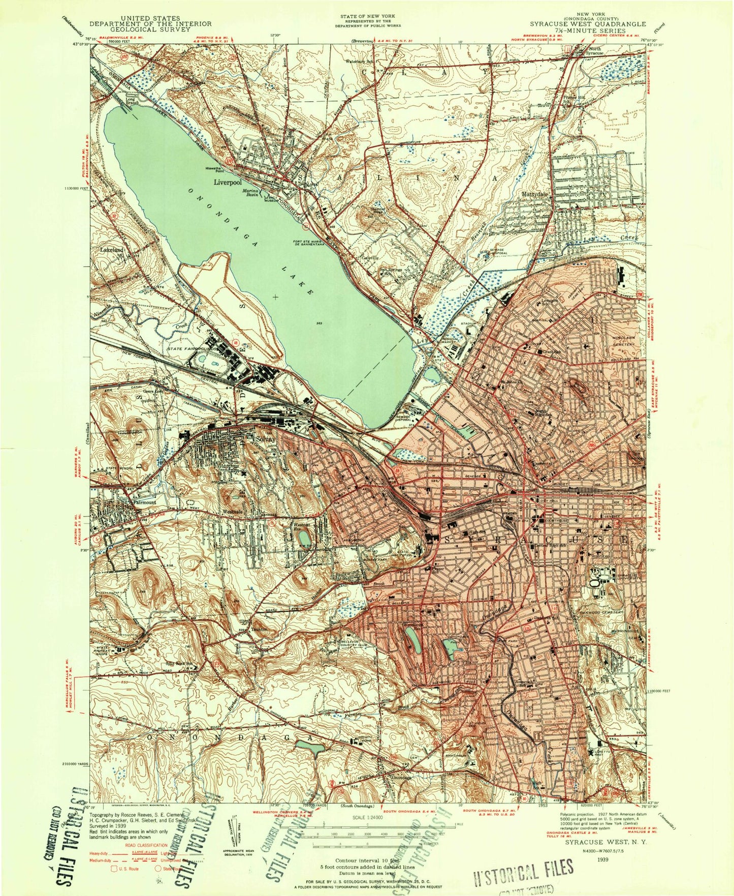
Classic USGS Syracuse West New York 7.5'x7.5' Topo Map
Couldn't load pickup availability
Historical USGS topographic quad map of Syracuse West in the state of New York. Typical map scale is 1:24,000, but may vary for certain years, if available. Print size: 24" x 27"
This quadrangle is in the following counties: Onondaga.
The map contains contour lines, roads, rivers, towns, and lakes. Printed on high-quality waterproof paper with UV fade-resistant inks, and shipped rolled.
Contains the following named places: Assumption Cemetery and Mausoleum, Beartrap Creek, Bellevue Heights United Methodist Church, Burnet Park, Central High School, Cherry Road Elementary School, Chestnut Hill Middle School, Chestnut Ridge, Clinton School, Corcoran High School, Croton School, Danforth School, Delaware Academy, Donlin Drive Elementary School, Elmwood Park, Elmwood Elementary School, Fairmount, Fairmount School, Franklin Elementary School, Frazer K - 8 School, Furnace Brook, Galeville, Garfield School, Geddes Brook, Grace Church, Grant Middle School, Harbor Brook, Hazzard Street School, Hiawatha Lake, Hiawatha Point, Hinsdale, Holy Family School, Hughes Elementary School, Slavic Baptist Church, Jefferson School, Kirk Park, Lake Outlet, Lakeland, Lakeview Point, LeMoyne Elementary School, Ley Creek, Lincoln Park, Lincoln School, Liverpool, Liverpool Middle School, Loomis Hill, Loretto Rest, Loveless School, Bishop Ludden Junior - Senior High School, Lyncourt School, Madison School, Maple Bay, Marina Basin, Mattydale, McKinley Playground, McKinley - Brighton Elementary School, Merrick School, Morningside Cemetery (historical), Mount Sinai Cemetery, Myrtle Hill Cemetery, New Apostolic Church, Ninemile Creek, North High School, North Medical Center, Oakwood Cemetery, Onondaga Community College, Onondaga Creek, Onondaga Hill, Onondaga Lake, Onondaga Park, Onondaga Road Elementary School, Onondaga Sanitarium, Onondaga Valley Academy, Nate Perry Elementary School, Pitcher Hill, Pitcher Hill School, Porter Elementary School, Prescott School, Riordan School, Roberts K - 8 School, Danforth Middle School, Roxboro Road Elementary School, Saint Agnes Cemetery, Saint Anns School (historical), Saint Anthonys School, Saint Brigids School, Saint Charles Borromeo School, Saint Daniels School, Saint Elias Orthodox Church, Saint Johns School, Saint Joseph's Hospital Health Center, Saint Josephs School, Saint Margarets School, Saint Marys Hospital, Saint Matthew's Episcopal Church, Saint Patricks School (historical), Saint Peters Catholic Church, Salem Hyde Elementary School, Salina School, Salt Museum, Sawmill Creek, Schiller Park, Seymour Dual Language Academy, Smith High School, Solvay, Split Rock, Split Rock Gulf, Suny at Syracuse, Syracuse, Syracuse State School, Syracuse University, Taunton, The Convent School, Thornden Park, Tompkins School, Town Park South, Tunnel Reservoir, Van Duyn Hospital, Van Duyn Elementary School, Vocational High School, Walberta Park Primary School, Washington Irving School, Webster Elementary School, Westcott Reservoir, Westhill High School, Westvale, Woodland Reservoir, Woodlawn Cemetery, Zogg Middle School, Long Branch, Onondaga County, Fort Sainte Marie De Gannentaha, Archbold Stadium (historical), Bellevue Country Club, MacArthur Stadium (historical), WJFG-AM (Solvay), WAQX-AM (Syracuse), WHEN-AM (Syracuse), WOLF-AM (Syracuse), WJPZ-FM (Syracuse), WAER-FM (Syracuse), WSNR-TV (Syracuse), Crouse Irving Memorial Hospital Heliport, Suny Health Science Center Heliport, Onondaga Lake Seaplane Base, Town of Geddes, Town of Salina, City of Syracuse, Lyncourt, Baker Laboratories, Sadler Hall, Richard H Hutchings Psychiatric Center, Johnson Park, Liverpool Village Hall, Onondaga Lake Park, Liverpool Grammar School (historical), Lamb Park, Washington Park, Village Green, Liverpool First Presbyterian Church, German Methodist Episcopal Church (historical), Saint Paul's Evangelical Lutheran Church (historical), Saint Joseph's Roman Catholic Church (historical), Fairmount Census Designated Place, Galeville Census Designated Place, Lakeland Census Designated Place, Lyncourt Census Designated Place, Mattydale Census Designated Place, Westvale Census Designated Place, Village of Liverpool, Village of Solvay, Clark Tower, Institute For Human Performance, Jacobsen Hall, Setnor Academic Building, Silverman Hall, Weiskotten Hall, Hill Medical Center, Madison-Irving Medical Center, Rosewood Heights Health Center, Syracuse Veterans Affairs Medical Center, University Health Care Center, Upstate University Hospital - Downtown Campus, Marley Education Center, SUNY Upstate Medical University, SUNY College of Environmental Science and Forestry, Bray Hall, Illick Hall, Jahn Laboratory, Walters Hall, Carrier Dome, College of Law White Hall, Heroy Geology Laboratory, Steele Hall, Hendricks Chapel, Syracuse University Physics Building, Archibold Gymnasium, Flanagan Gymnasium, Carnegie Library, Bowne Hall, Lowe Art Gallery, Sims Hall, Slocum Hall, Link Hall, Lyman Hall, Machinery Hall, Hinds Hall, Smith Hall, Hall of Languages, H. B. Crouse Building, Tolley Administrative Building, Eggers Hall, Maxwell Hall, Crouse College, Holden Observatory, Marley Education Center, Crouse-Hinds School of Management, Newhouse Hall, Schine Student Center, E. S. Bird Library, Goldstein Alumni and Faculty Center, Watson Residence Hall, DellPlain Residence Hall, Booth Residence Hall, Kimmel Residence Hall and Dining Center, Marion Residence Hall, Slutzker Center for International Studies, Sheraton University Hotel and Conference Center, Syracuse University Health Services Center, Huntington Hall, Hoopie Hall, Marshall Square Mall, Syracuse University School of Management, Walnut Residence Hall, Haven Residence and Dining Hall, Syracuse University School of Nursing


