MyTopo
Classic USGS Tellico Plains Tennessee 7.5'x7.5' Topo Map
Couldn't load pickup availability
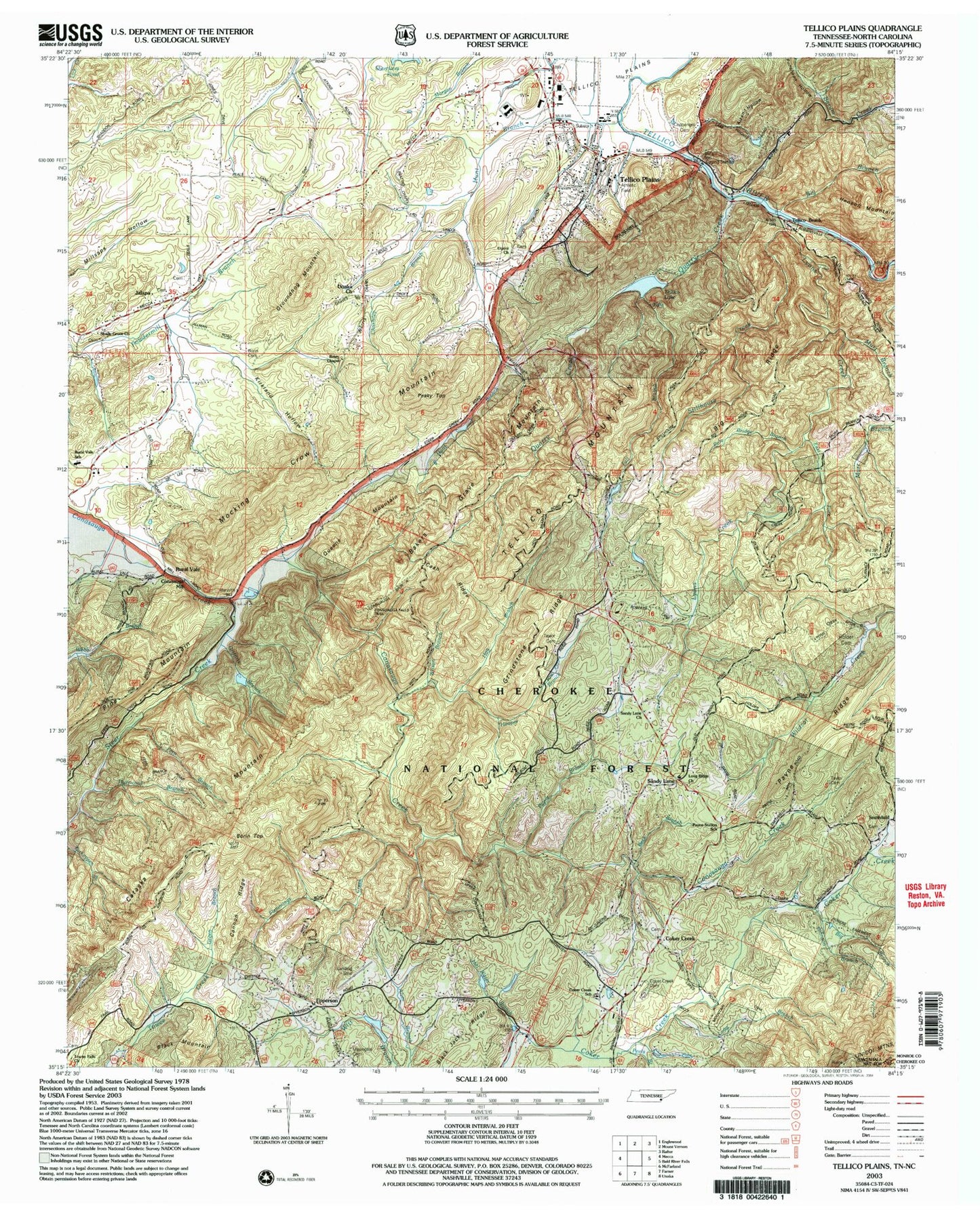
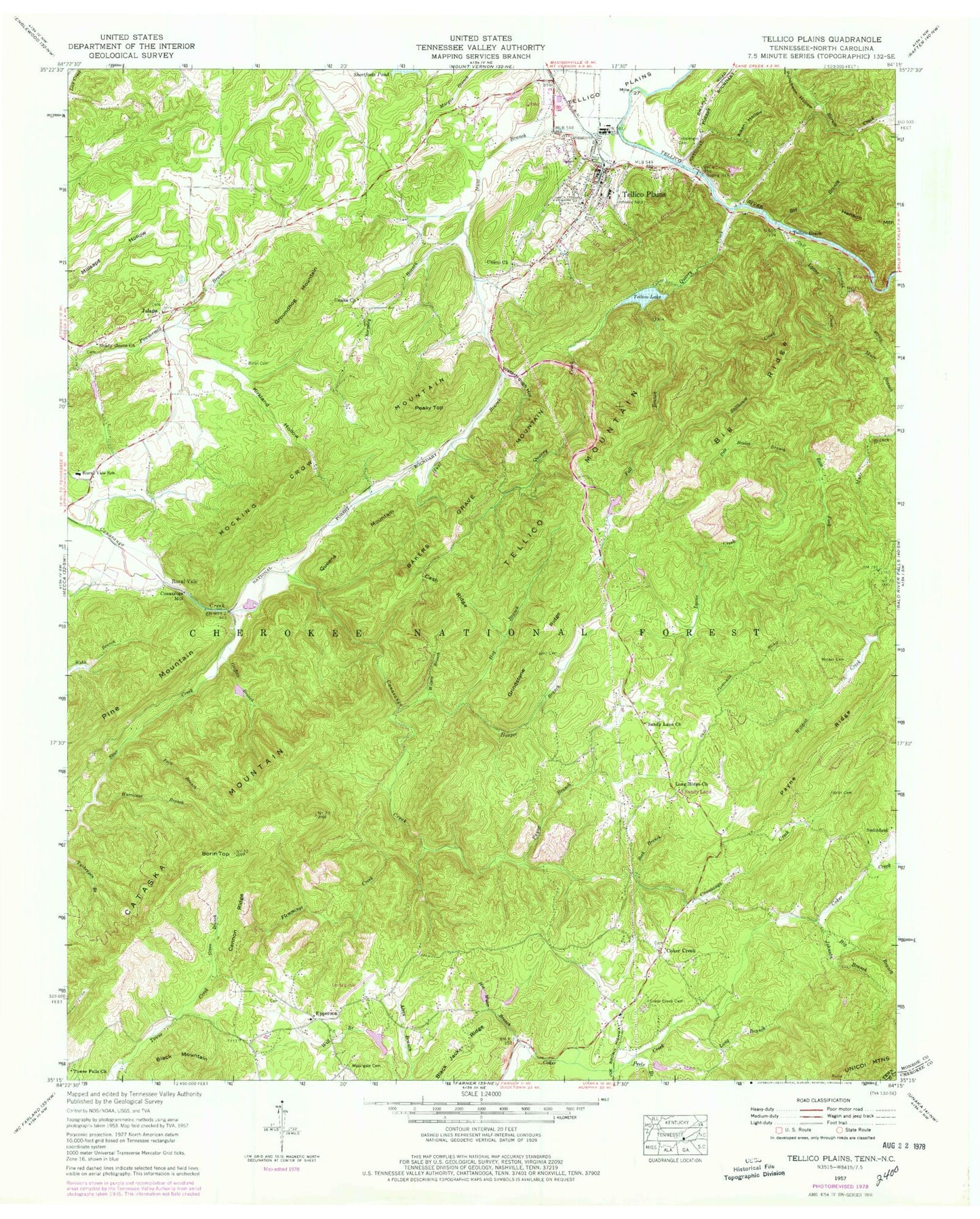
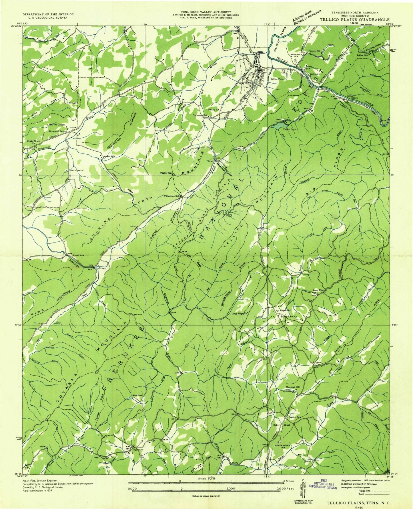
Historical USGS topographic quad map of Tellico Plains in the state of Tennessee. Typical map scale is 1:24,000, but may vary for certain years, if available. Print size: 24" x 27"
This quadrangle is in the following counties: Cherokee, Monroe.
The map contains contour lines, roads, rivers, towns, and lakes. Printed on high-quality waterproof paper with UV fade-resistant inks, and shipped rolled.
Contains the following named places: Tellico Plains Division (historical), Steer Creek, Stillhouse Creek, Taylor Cemetery, Tellico Beach, Tellico Mountain, Wilson Branch, Witt Branch, Bakers Grave Mountain, Beck Branch, Big Branch, Big Branch, Borin Cemetery, Borin Top, Cannon Ridge, Cash Ridge, Coker Creek Cemetery, East Fork Lyons Creek, Fall Branch, Fern Branch, Flemmings Creek, Green Branch, Griffitts Branch, Grindstone Ridge, Groundhog Mountain, Hog Branch, Holder Cemetery, Hooper Branch, Hot Water Branch, Hunt Branch, Hurricane Branch, Jalapa, Johnson Branch, Kirkland Hollow, Long Branch, Long Ridge Church, Lyons Creek, Masingale Cemetery, Mocking Crow Mountain, Payne Branch, Payne Ridge, Peaky Top, Peels Branch, Pole Bridge Branch, Quarry Creek, Queens Mountain, Sandy Lane, Sandy Lane Church, Shady Grove Church, Unicoi Lake, Unicoi Dam, Yeller Nugget Lake, Yeller Nugget Lake Dam, Sanford Gray Lake Dam Number One, Sanford Gray Lake Number One, Elbert Martin Dam, Elbert Martin Lake, Tellico Lake, Tellico Plains, Towee Falls Church, Unaka Church, Unicoi Church, Watertrough Hollow, Aiken Hollow, Black Jack Ridge, Cataska Mountain, Chormley Branch, Coppenger Cemetery, Tellico Lake Dam, Atkins School (historical), Coker Creek Baptist Church, Jacktown, Leonards Chapel, Long Ridge Church (historical), Murphys Mill (historical), Payne School (historical), Sawmill Branch, Smithfield School (historical), Station School (historical), Sugartree Branch, Tellico Iron Works (historical), Tellico Plains Elementary School, Whites Chapel (historical), Williamson School (historical), Witts Pond (historical), Smithfield, Coker Creek, Conasauga Mill, Epperson, Rural Vale, Epperson School (historical), First Baptist Church of Tellico Plains, Shady Grove Baptist Church Cemetery, Tellico Plains Cemetery, Unicoi Missionary Baptist Church Cemetery, Murr Branch, Tellico Beach, Unicoi Church, Beaty Chapel, Shady Grove Church, Unaka Church, Borin Cemetery, Masingale Cemetery, Coker Creek Cemetery, Doc Rogers Trail, Coker Creek School, Towee Falls Church, Big Ridge, Rural Vale School, Conasauga Falls Trail, Holder Cemetery, Sandy Lane, Long Ridge Church, Sandy Lane Church, Taylor Cemetery, Payne Station School, Coppenger Cemetery, Alvin Branch Workings, Annette Workings, Big Branch Workings, Big Surface Workings, Blackjack Ridge Mine, Brown Hill School (historical), Calf Yoke Mine, Calf Yoke Workings, Cindy Hole Mine, Cut-Off, El Tigre Mine, Gear Workings, Johnson Branch, Johnson Branch Workings, Johnson Mine, Johnson Prospect, Lenderman Mine, Lenderman Prospect, Lost River Mine, Lower Johnson Mine, McAllister Branch, McAllister Branch Workings, Payne Station School (historical), Towee Falls (historical), Upper Johnson Mine, Wildcat Creek Workings, Conasauga Falls Trail, Doc Rogers Trail, Rural Vale Elementary School, Coker Creek Post Office, Tellico Plains Post Office, Coker Creek Elementary School, Town of Tellico Plains, Coker Creek Volunteer Fire Department, Tellico Plains Fire Department, Conasauga Valley Fire Department, Tellico Plains Police Department, Coker Creek Census Designated Place, Tellico Plains Division (historical), Steer Creek, Stillhouse Creek, Taylor Cemetery, Tellico Beach, Tellico Mountain, Wilson Branch, Witt Branch, Bakers Grave Mountain, Beck Branch, Big Branch, Big Branch, Borin Cemetery, Borin Top, Cannon Ridge, Cash Ridge, Coker Creek Cemetery, East Fork Lyons Creek, Fall Branch, Fern Branch, Flemmings Creek, Green Branch, Griffitts Branch, Grindstone Ridge, Groundhog Mountain, Hog Branch, Holder Cemetery, Hooper Branch, Hot Water Branch, Hunt Branch, Hurricane Branch, Jalapa, Johnson Branch, Kirkland Hollow, Long Branch, Long Ridge Church, Lyons Creek, Masingale Cemetery, Mocking Crow Mountain, Payne Branch, Payne Ridge, Peaky Top, Peels Branch, Pole Bridge Branch, Quarry Creek, Queens Mountain, Sandy Lane, Sandy Lane Church, Shady Grove Church, Unicoi Lake, Unicoi Dam, Yeller Nugget Lake, Yeller Nugget Lake Dam, Sanford Gray Lake Dam Number One, Sanford Gray Lake Number One, Elbert Martin Dam, Elbert Martin Lake, Tellico Lake, Tellico Plains, Towee Falls Church, Unaka Church, Unicoi Church, Watertrough Hollow, Aiken Hollow, Black Jack Ridge, Cataska Mountain, Chormley Branch, Coppenger Cemetery, Tellico Lake Dam, Atkins School (historical), Coker Creek Baptist Church, Jacktown, Leonards Chapel, Long Ridge Church (historical), Murphys Mill (historical), Payne School (historical), Sawmill Branch, Smithfield School (historical), Station School (historical), Sugartree Branch, Tellico Iron Works (historical)