MyTopo
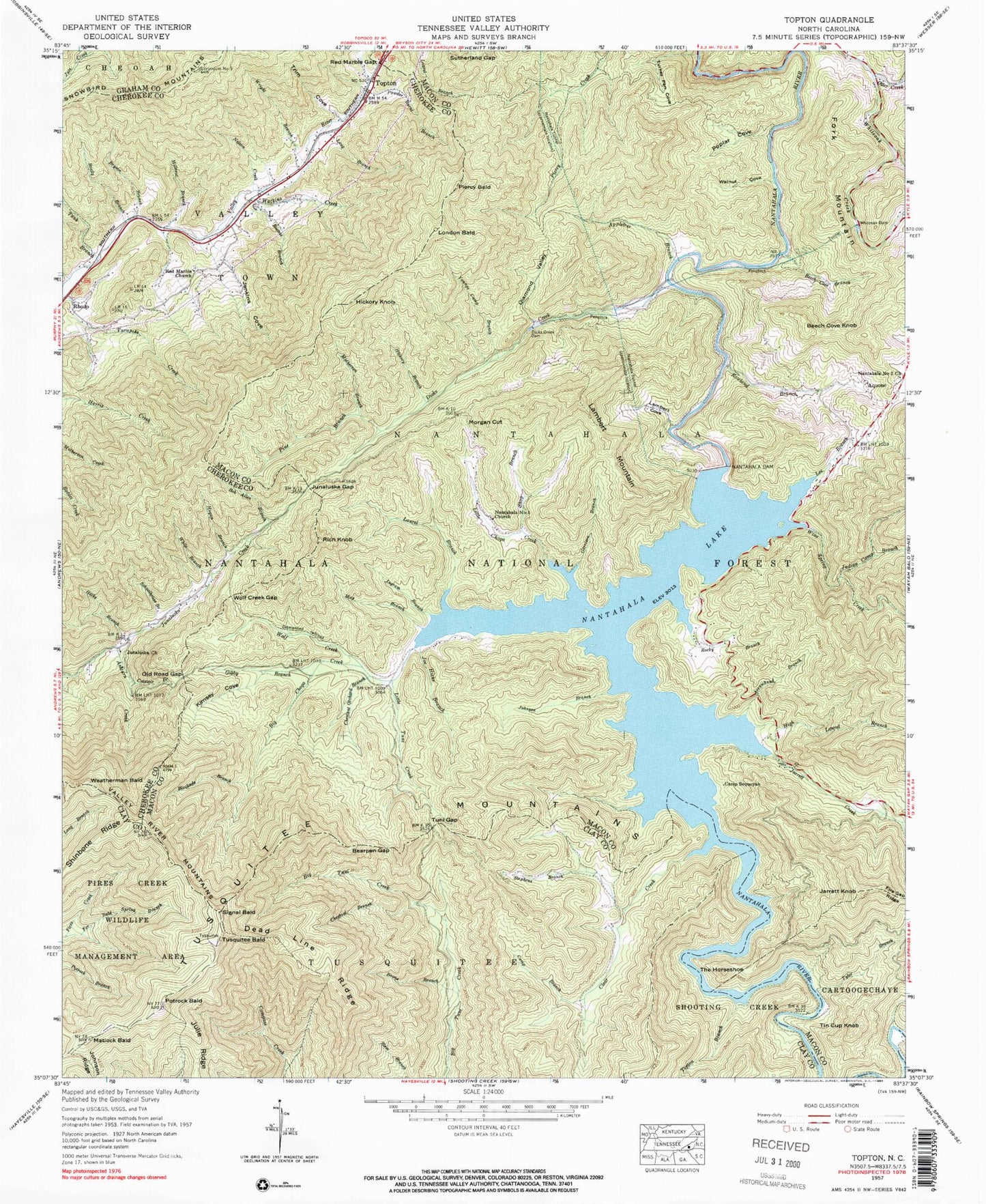
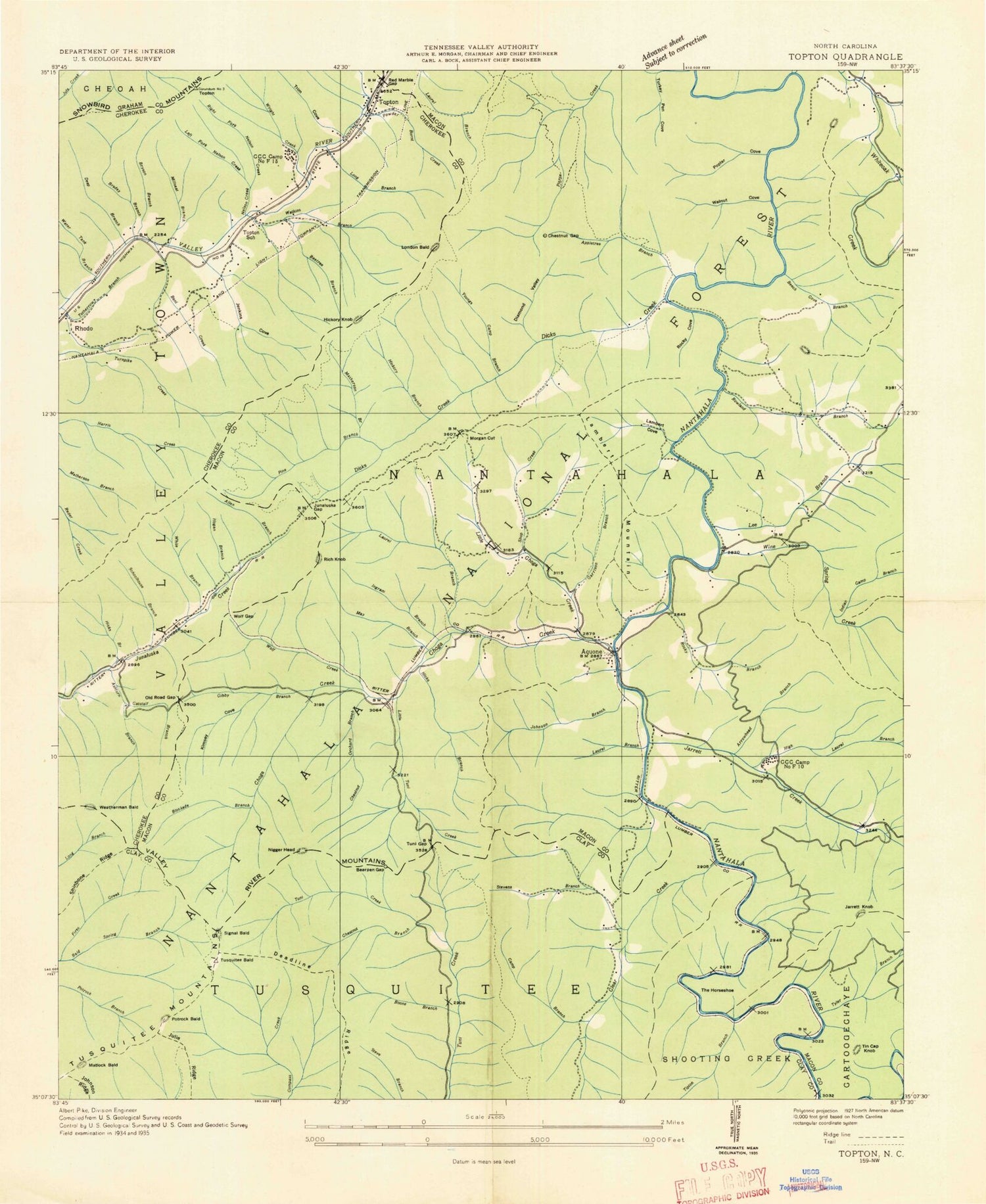
Classic USGS Topton North Carolina 7.5'x7.5' Topo Map
Couldn't load pickup availability
Historical USGS topographic quad map of Topton in the state of North Carolina. Typical map scale is 1:24,000, but may vary for certain years, if available. Print size: 24" x 27"
This quadrangle is in the following counties: Cherokee, Clay, Graham, Macon.
The map contains contour lines, roads, rivers, towns, and lakes. Printed on high-quality waterproof paper with UV fade-resistant inks, and shipped rolled.
Contains the following named places: Appletree Branch, Arrowhead Branch, Ashturn Creek, Bearpen Gap, Beech Cove Branch, Beetree Branch, Blockade Branch, Bob Allen Branch, Boone Branch, Brady Branch, Bryson Branch, Camp Branch, Camp Sequoyah, Catstair Branch, Chestnut Branch, Chestnut Orchard Branch, Clear Creek, Diamond Valley, Dicks Creek, Dicks Creek Dam, Far Bald Spring Branch, Garrison Branch, Gibby Branch, Hickory Branch, Hicks Branch, High Laurel Branch, Hogan Branch, Hurricane Creek, Indian Camp Branch, Ingram Branch, Jarrett Creek, Jenkins Cove, Joe Hicks Branch, Johnson Branch, Junaluska Church, Junaluska Gap, Kimsey Cove, Lambert Cove, Laurel Branch, Lee Branch, Little Choga Creek, Little Tuni Creek, Long Branch, Long Branch, Matherson Branch, Matlock Bald, May Branch, Millseat Branch, Morgan Cut, Nantahala Dam, Nantahala Lake, Nelson Creek, Old Road Gap, Pine Branch, Poplar Cove, Potrock Bald, Red Marble Church, Rocky Branch, Rowland Branch, Schoolhouse Branch, Shop Branch, Stephens Branch, Sutherland Gap, Trim Cove, Tuni Gap, Turkey Pen Cove, Walnut Cove, Watkins Creek, White Branch, Whiteoak Dam, Wolf Creek, Wolf Creek Gap, Wright Branch, Youngs Camp Branch, The Horseshoe, Bob Allison Picnic Area, Dead Line Ridge, Johnson Ridge, Julie Ridge, Mill Branch, Nantahala Tunnel, Otter Creek, Red Marble Gap, Shinbone Ridge, Silvermine Branch, Tank Branch, Tipton Branch, Tusquitee Mountains, Tyler Branch, Valley River Mountains, Wine Spring Creek, CHoga Trail, Penstock, Appletree Campground, Aquone, Beech Cove Knob, Fork Mountain, Hickory Knob, Jarrett Knob, Lambert Mountain, London Bald, Piercy Bald, Powder Burnt Branch, Rich Knob, Signal Bald, Tin Cup Knob, Topton, Tusquitee Bald, Weatherman Bald, Nantahala Number 1 Church, Nantahala Number 2 Church, Township of Nantahala, Choga Creek, Clay Knob, Nantahala Volunteer Fire and Rescue Department, Macon County Emergency Medical Services - Nantahala Station, Topton Post Office