
MyTopo
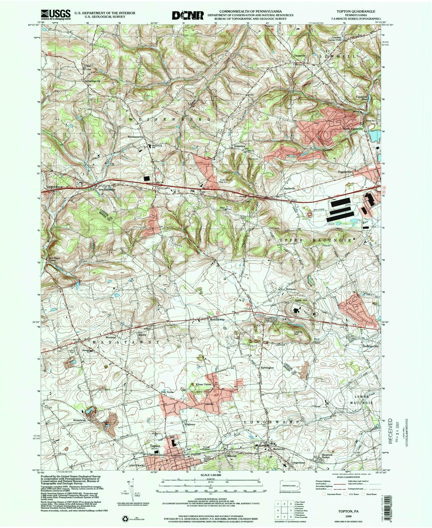
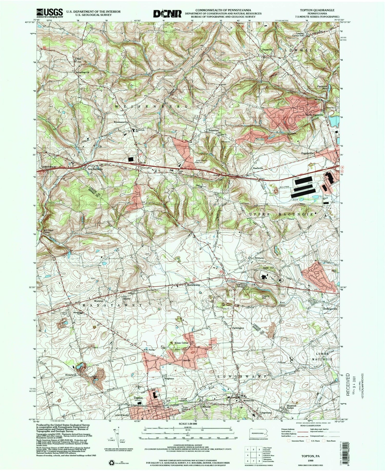
Classic USGS Topton Pennsylvania 7.5'x7.5' Topo Map
Couldn't load pickup availability
Historical USGS topographic quad map of Topton in the states of Pennsylvania, New Jersey. Typical map scale is 1:24,000, but may vary for certain years, if available. Print size: 24" x 27"
This quadrangle is in the following counties: Berks, Lehigh.
The map contains contour lines, roads, rivers, towns, and lakes. Printed on high-quality waterproof paper with UV fade-resistant inks, and shipped rolled.
Contains the following named places: Breinig Run, Breinigsville, Cherry Hill, Claussville, East Penn School, Farmington, Fogelsville, Fogelsville Pond, Haas Hill, Hancock, Klines Corner, Maxatawny, Mertztown, North Fogelsville, Ringtown, Saint Pauls Church, Seipstown, Shamrock Station, Toad Creek, Topton, Ziegels Union Church, Zion Church, Zion Church, Zettlemoyer Airport (historical), The Cove, Laros (historical), Wallner (historical), Hartzell (historical), Helfrichsville, Zeigels School, Rupp School, Hynemansville School (historical), Gackenbachs School, Grim Independent School, Bucks School, Apple School, Stone Quarry School, Siegfriedsdale School, Mill Creek School, Farmington School, Hottenstein School, Hinterleiter School, Oreville, Five Points, Haafsville, Hinterleiter, Hynemansville, Mill Creek Corner, Monterey, New Smithville, Newtown, Schofer, Seiberlingville, Maxatawney Elementary School, Weisenberg Elementary School, Longswamp Elementary School, Pennsylvania State University - Allentown Campus, Leather Corner Post, Borough of Topton, Township of Maxatawny, Township of Weisenberg, Weisenberg, Berks-Lehigh Regional Police Department, Brandywine Heights High School, Country View Mobile Home Park, Evangel Assembly of God, Longswamp Community Park, Longswamp Township Office, Rodale Institute Experimental Farm, Saint Paul's Evangelical Lutheran Church, Saint Pauls Union Cemetery, Saint Pauls United Church of Christ, Maxatawny Township Offices, Topton Community Park, Topton Industrial Park, Topton Post Office, Topton Volunteer Fire Company 1 Station 21, Topton Union Cemetery, Zion Church Cemetery, Mertztown Census Designated Place, Breinigsville Census Designated Place, Fogelsville Volunteer Fire Company Station 8, Topton American Legion Community Ambulance, Breinigsville Post Office, Maxatawny Post Office, Mertztown Post Office, Geehr Cemetery, Grim Cemetery, Hottenstein Burial Ground, Kutz Family Graveyard, Salem Evangelical Cemetery, Sassaman Family Cemetery, Schmidt Family Burial Ground, Siegfried Family Cemetery, Trexler Cemetery, Pennsylvania State Police Troop M Fogelsville Station, Fogelsville Post Office, Ziegels Union Cemetery, Saint Johns United Church of Christ Cemetery, Saint Pauls Church Cemetery, United Brethren Cemetery, Trexler Private Cemetery, Salem Church of the United Brethren in Christ Cemetery, Maxatawny Census Designated Place, Mid-State Heliport