MyTopo
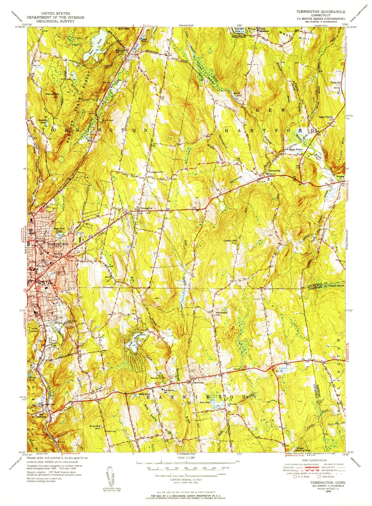
Classic USGS Torrington Connecticut 7.5'x7.5' Topo Map
Couldn't load pickup availability
Historical USGS topographic quad map of Torrington in the state of Connecticut. Typical map scale is 1:24,000, but may vary for certain years, if available. Print size: 24" x 27"
This quadrangle is in the following counties: Hartford, Litchfield.
The map contains contour lines, roads, rivers, towns, and lakes. Printed on high-quality waterproof paper with UV fade-resistant inks, and shipped rolled.
Contains the following named places: Bakersville, Bakersville Brook, Besse Park Pond, Bull Pond, Burr Pond, Burrville, Camp Berkshire, Camp Trinita, Catlin Brook, Cedar Swamp, Cedar Swamp Brook, Center Cemetery, Cotton Hill, East Branch Dam, East Branch Leadmine Brook, East Branch Naugatuck River, East Cemetery, East School, Finnak Brook, Goodwin Pond, Gulf Stream, Harmony Hill, Harwinton Consolidated School, Lake Harwinton, Iffland Pond, Kelly Pond, Kelly Pond Brook, Maple Hollow, Nepaug Marsh, New Saint Francis Cemetery, North Brook North Nepaug Brook, North Cemetery, North Nepaug Brook, Vogel-Wetmore School, Paugnut State Forest, Pickett Brook, Powder Brook, Scoville Cemetery, Scoville Hill, Sons of Jacob Cemetery, South Cemetery, South Nepaug Brook, South School, Torringford, Torringford Brook, Torringford Church, Torringford Elementary School, Torrington, Travis Pond, Troy Brook, Turtle Rock, Walnut Mountain, West Branch Leadmine Brook, West Branch Naugatuck River, West Cemetery, West Hill, Wolcott School, Yellow Mountain, East Litchfield, Harwinton, Mountain Meadow Airstrip (historical), O and G Heliport, WSNG-AM (Torrington), Town of Harwinton, Town of New Hartford, Burr Pond Dam, Lake Harwinton Dam, Bull Pond Dam, East Branch Naugatuck River Reservoir, Rizzo Pond Dam, Rizzo Pond, Alvord Park, Ann Antolini School, Bakerville Consolidated School, Bakerville Library, Bakerville Methodist Church, Birge Park Shopping Center, Boy Scout Service Center, Burr Pond State Park, Calvary Baptist Church, Church of Christ, City of Torrington Street Division Garage, Coe Memorial Park, Downtown Torrington Historic District, East Elementary School, Elise Besse Park, Faith Tabernacle Apostolic Church, First Assembly of God Church, Founders Congregational Church, Four Corners (historical), Fuessenich Park, Full Gospel Lighthouse Church, Harvest Baptist Church, Harwinton Community Hall, Harwinton Congregational Church, Harwinton Conservation and Recreation Area, Harwinton Fair Grounds, Harwinton Post Office, Harwinton Public Library, Harwinton Town Garage, Harwinton Town Hall, Harwinton Shopping Center, Harwinton Town Hall, Harwinton Volunteer Fire Department, Hayden Hill, Hotchkiss-Fyler House, Hungerford Memorial Library, Immaculate Heart of Mary Church, Joe Ruwet Playground, John Thompson Memorial Library, John Toro Sports Complex, Kasznay Shopping Center, Living Faith Christian Center, Meetinghouse Hill, Nepash Meadows, Old Post Office Square Shopping Center, Oxbow Park, Patterson Park, Pleasant View Park, Center Congregational Church, Center Congregational Church, Torrington Library, United Church of Christ, Northwest Harwinton Census Designated Place, Harwinton Westside Volunteer Fire Department, Torrington Fire Department Headquarters, Burrville Volunteer Fire Department, New Hartford Fire Department Station 2, Burrville Regional Fire School, Torringford Volunteer Fire Department, Torrington Fire Department North End Station, Western Connecticut Mental Health Care System, Harwinton Ambulance Association, Torrington Police Department, Bakersville, Bakersville Brook, Besse Park Pond, Bull Pond, Burr Pond, Burrville, Camp Berkshire, Camp Trinita, Catlin Brook, Cedar Swamp, Cedar Swamp Brook, Center Cemetery, Cotton Hill, East Branch Dam, East Branch Leadmine Brook, East Branch Naugatuck River, East Cemetery, East School, Finnak Brook, Goodwin Pond, Gulf Stream, Harmony Hill, Harwinton Consolidated School, Lake Harwinton, Iffland Pond, Kelly Pond, Kelly Pond Brook, Maple Hollow, Nepaug Marsh, New Saint Francis Cemetery, North Brook North Nepaug Brook, North Cemetery, North Nepaug Brook, Vogel-Wetmore School, Paugnut State Forest, Pickett Brook, Powder Brook, Scoville Cemetery, Scoville Hill, Sons of Jacob Cemetery, South Cemetery, South Nepaug Brook, South School, Torringford, Torringford Brook, Torringford Church, Torringford Elementary School, Torrington, Travis Pond, Troy Brook, Turtle Rock, Walnut Mountain, West Branch Leadmine Brook, West Branch Naugatuck River, West Cemetery, West Hill, Wolcott School, Yellow Mountain, East Litchfield, Harwinton, Mountain Meadow Airstrip (historical), O and G Heliport, WSNG-AM (Torrington), Town of Harwinton, Town of New Hartford, Burr Pond Dam, Lake Harwinton Dam, Bull Pond Dam, East Branch Naugatuck River Reservoir, Rizzo Pond Dam, Rizzo Pond, Alvord Park, Ann Antolini School, Bakerville Consolidated School, Bakerville Library, Bakerville Methodist Church, Birge Park Shopping Center, Boy Scout Service Center, Burr Pond State Park, Calvary Baptist Church, Church of Christ, City of Torrington Street Division Garage, Coe Memorial Park, Downtown Torrington Historic District, East Elementary School, Elise Besse Park, Faith Tabernacle Apostolic Church, First Assembly of God Church, Founders Congregational Church, Four Corners (historical), Fuessenich Park, Full Gospel Lighthouse Church, Harvest Baptist Church, Harwinton Community Hall, Harwinton Congregational Church, Harwinton Conservation and Recreation Area, Harwinton Fair Grounds, Harwinton Post Office, Harwinton Public Library, Harwinton Town Garage, Harwinton Town Hall, Harwinton Shopping Center