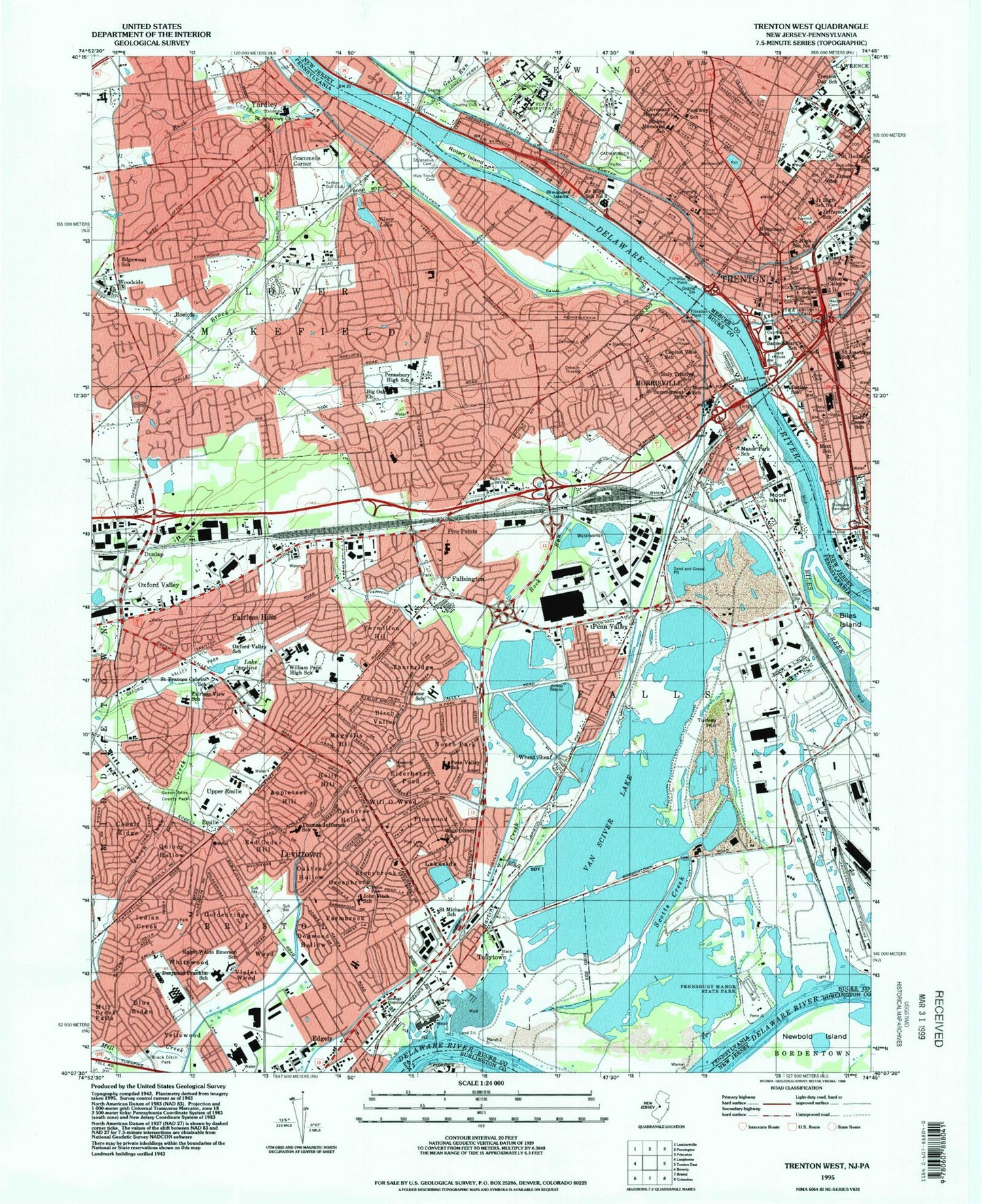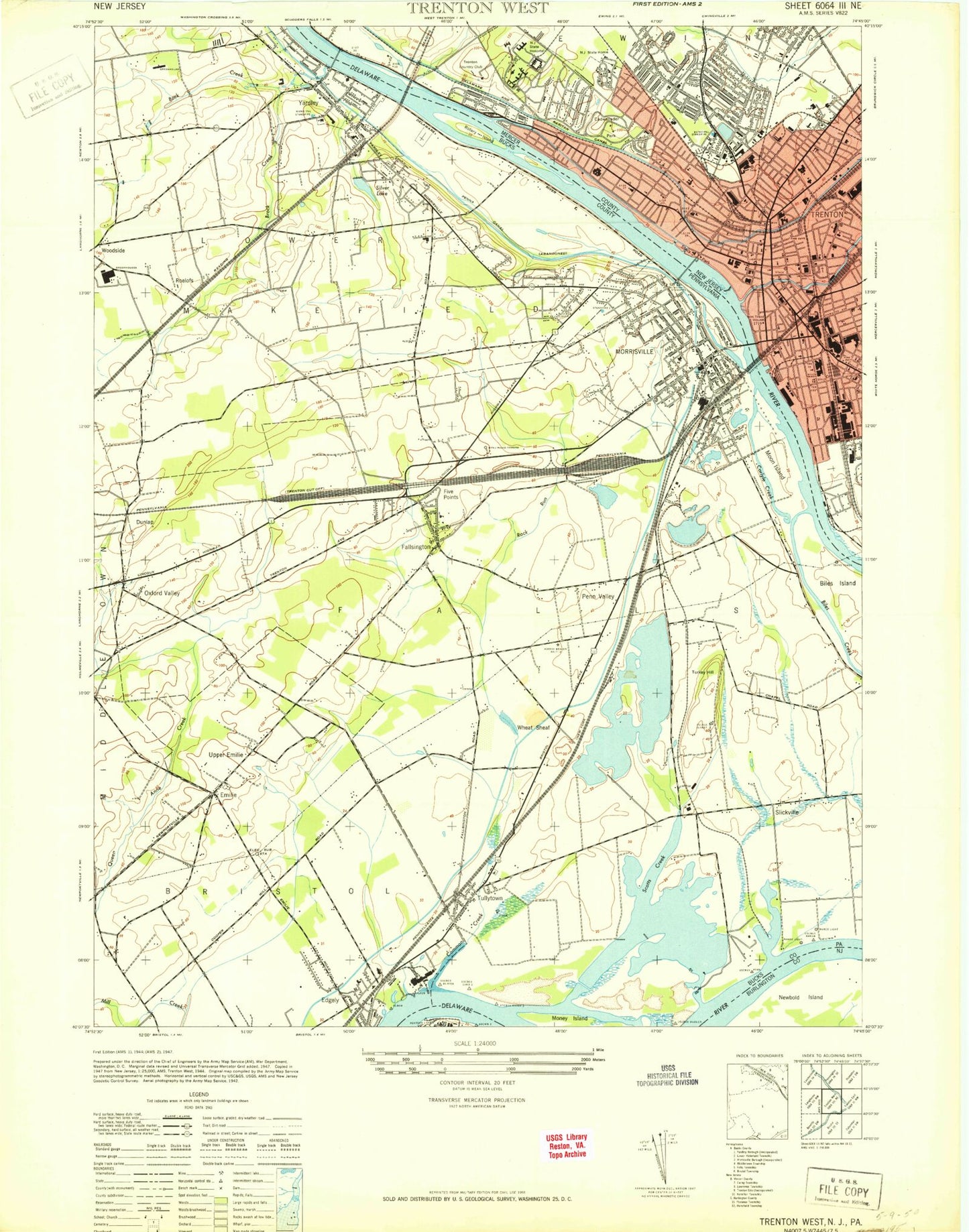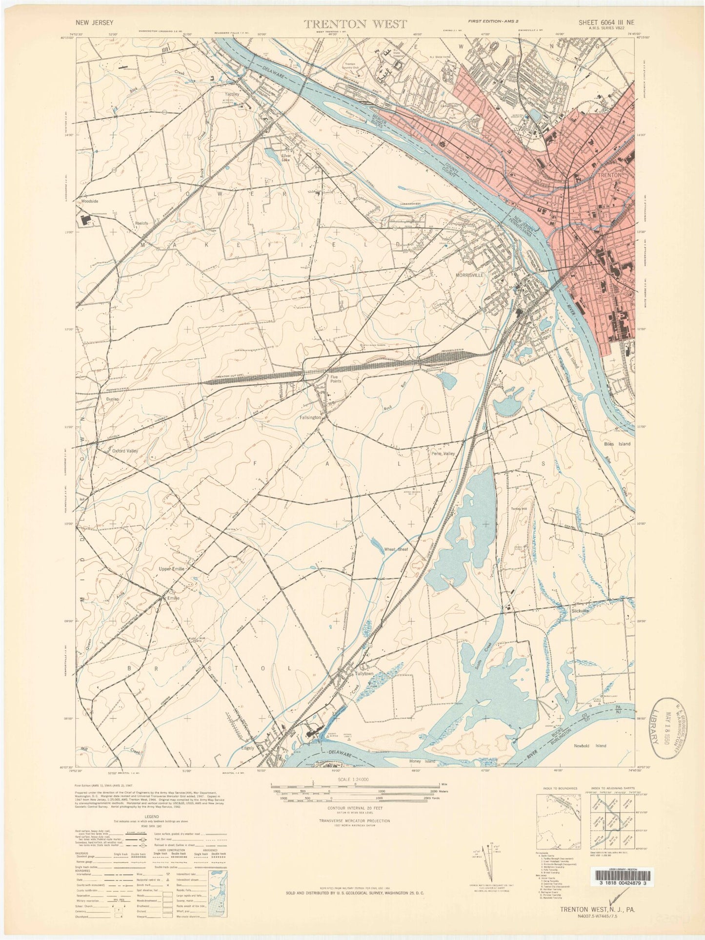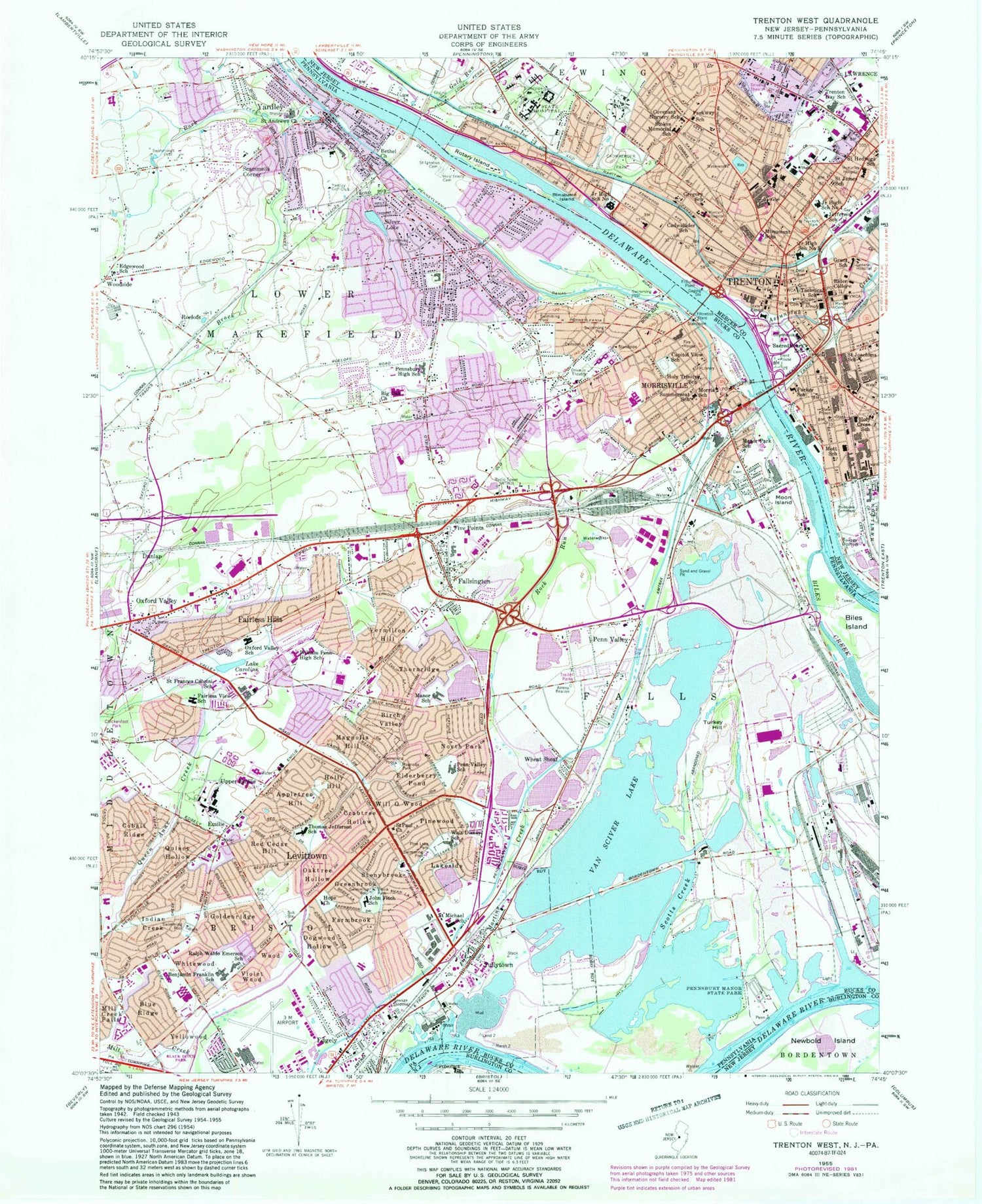


MyTopo
Classic USGS Trenton West New Jersey 7.5'x7.5' Topo Map
Couldn't load pickup availability
Historical USGS topographic quad map of Trenton West in the states of New Jersey, Pennsylvania. Typical map scale is 1:24,000, but may vary for certain years, if available. Print size: 24" x 27"
This quadrangle is in the following counties: Bucks, Burlington, Mercer.
The map contains contour lines, roads, rivers, towns, and lakes. Printed on high-quality waterproof paper with UV fade-resistant inks, and shipped rolled.
Contains the following named places: Assunpink Creek, Blauguard Island, Cadwalader Park, Cadwalader Elementary School, Covenant Nursery School, Gold Run, Grant Elementary School, Benjamin C Gregory Elementary School, Holy Cross School, Jefferson School, Junior High School Number 1, Junior High School Number 5, Capital Health System Regional Medical Center, Mercer Cemetery, Capital Health System Medical Center Mercer Campus, Monument Elementary School, Gershom Mott Elementary School, Newbold Island, North Trenton Park, Parker Elementary School, Parkway Elementary School, Rider College, Riverview Cemetery, Rotary Island, Sacred Heart School of Trenton, Saint Hedwig School, Saint James School, Saint Joachims School, Stacy Park, New Jersey State House, Joseph Stokes Memorial Elementary School, Technical School, Teen House, Trenton Day School, Mercer Medical Center, Cochran Channel, Florence Bend, Kinkora Range, Moon Channel, Newbold Channel, Penn Channel, Trenton Channel, Trenton Marine Terminal, Trent House, Hillcrest, Glendale, Weber Park, Prospect Heights, Prospect Park, Trenton Country Club, Trenton Heliport, WPST-FM (Trenton), City of Trenton, New Jersey State Prison, Luis Munoz Rivera Elementary School, Trenton Community Charter School, Thomas Jefferson Elementary School, Parker Elementary School Annex II, Foundation Academy Charter School, Afrikan Peoples Action School, Trenton County High School Medical Arts Academy, Daylight Twilight High School, Thomas Edison State College, Emily Fisher Charter School of Advanced Studies, Trinity Cathedral Academy School, International Charter School of Trenton, Joyce Kilmer Elementary School, Mount Sinai Seventh Day Adventist School, Martin Luther King Junior Middle School, The Village Charter School, Trenton Central High School West, Trenton Fire and Emergency Services Engine 10 Ladder 4 Rescue 1, Trenton Fire and Emergency Services Engine 8, Trenton Fire and Emergency Services Engine 1 Ladder 1, Prospect Heights Volunteer Fire Company Station 1, Trenton Fire and Emergency Services Engine 9, Trenton Fire and Emergency Services Engine 3 Ladder 2, Trenton Psychiatric Hospital, Ann Klein Forensic Center, New Jersey State Prison Hospital, Ewing Residential Center, Trenton Emergency Medical Services, Capital Health Emergency Medical Services, City of Trenton Police Department, Mercer County Sheriff's Office, United States Marshals Service Trenton, Luther Towers, Rowan Towers, Mary G Roebling Building, Luther Arms, Bernice J Munce Tower, French Towers, Mercer County Waterfront Park, Sovereign Bank Arena, Downtown Trenton Post Office, Silver Lake, Appletree Hill, Benjamin Franklin School, Bethel Church, Big Oak Church, Birch Valley, Blue Ridge, Brock Creek, Brook Park, Buck Creek, Capitol View School, Caroline Lake, Case School, Cobalt Ridge, Crabtree Hollow, Dogwood Hollow, Edgely, Elderberry Pond, Fairless Hills, Fairless View School, Fallsington, Farmbrook, Goldenridge, Greenbrook, Holly Hill, Holy Trinity Catholic Cemetery, Holy Trinity School, Hope Church, Indian Creek, John Fitch School, Lakeside, Levittown, Magnolia Hill, Magnolia Park, Manor Park School, Martins Creek, Mill Creek Falls, Money Island, Morris School, Morrisville, North Park, Oaktree Hollow, Oxford Valley, Penn Valley, Pennsbury High School, Pine Lake Park, Pinewood, Queen Anne Creek, Quincy Hollow, Red Cedar Hill, Rock Run, Saint Andrews Church, Saint Frances Cabrini School, Saint Ignatius Cemetery, Saint Michael School, Saint Paul Church, Scammells Corner, Scotts Creek, Stonybrook, Summerseat School, Thomas Jefferson School, Thornridge, Tullytown, Vermilion Hill, Violet Wood, Wheat Sheaf, Will O Wood, William Penn High School, Wood, Yardley, Yellowood, Moon Island, Pennsbury Manor State Park, Pennsylvania Canal, Turkey Hill, Van Sciver Lake, Whitewood, McClister Airport (historical), Manor Lake, Manor Lake Dam, Van Sciver Lake Dam, Lake Caroline Dam, Oxford Valley Mall Dam, Silver Lake Dam, Trenton Channel, Moon Channel, Cochran Channel, Newbold Channel, Penn Channel, Kinkora Range, Florence Bend, Edge Hill, Edgewood School, WBCB-AM (Lancaster), Mill Creek, Little Silver Lake, Dunlap, Emilie, Five Points, Roelofs, Upper Emilie, Bucks County Technical High School, Neil A Armstrong Middle School, George Washington Elementary School, Conwell - Egan Catholic High School, James Buchanan Elementary School, Harry S Truman High School, Clara Barton Elementary School, Edgewood Elementary School, Abrams Hebrew Academy, Quarry Hill Elementary School, Eleanor Roosevelt Elementary School, Makefield Elementary School, Charles H Boehm High School, Medill Bair High School, Pennsburg High School, Village Park Elementary School, Pearl S Buck Elementary School, Saint Ignatius Elementary School, U S Steel Industrial Park, Belaire Trailer Court, Penn Trailer Court, Pennwood Crossing Trailer Park, Tyburn, Penn Warner Industrial Park, Morningside, East Side, Grandview Elementary School, Washington Heights, Morrisville Junior Senior High School, Highland Park, Plaza Park, Pennsbury Plaza, Capital View, Morris Heights, Glen Wood, West Acres, Westover, Cedar Lake Trailer Park, Drexelwood, Melody Lakes Trailer Park