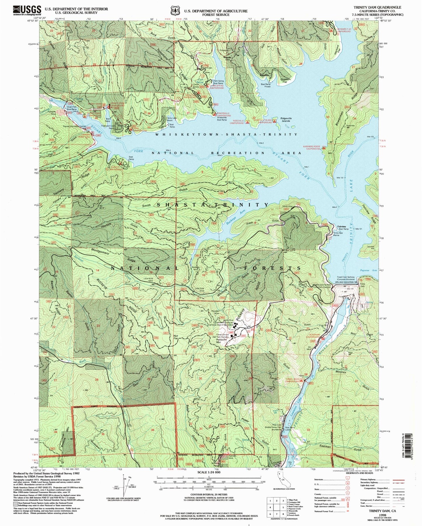
MyTopo
Classic USGS Trinity Dam California 7.5'x7.5' Topo Map
Couldn't load pickup availability
Historical USGS topographic quad map of Trinity Dam in the state of California. Map scale may vary for some years, but is generally around 1:24,000. Print size is approximately 24" x 27"
This quadrangle is in the following counties: Trinity.
The map contains contour lines, roads, rivers, towns, and lakes. Printed on high-quality waterproof paper with UV fade-resistant inks, and shipped rolled.
Contains the following named places: Ackerman Campground, After All Mine, Bales and Van Matre Mine, Batham Dredge Mine, Baxter Gulch, Baxter Ridge, Bear Gulch, Beaudry Mine, Boarding House Mine, Bonanza Mine, Buck Gulch, Buckeye Creek, Buckeye Mine, Buckeye Ridge, Bushytail Campground, Cedar Stock, Cement and Mule Creek Mine, Chicken Flat, China Gulch, Clark Spring, Clark Spring Campground, Cummings Creek, Cunningham Mine, Deer Gulch, Digger Creek, Digger Gulch, Dutch Gulch, Eastman Gulch, Eastman Mine, Estrellita, Fairview, Fairview Dredge Mine, Fairview Mine, Farley Gulch, Fawn Campground, Ferry Gulch, Haylock Gulch, Hayward Flat, Hayward Flat Campground, Humboldt Mine, Ingleside Mine, Irish Gulch, Italian Gulch, Kokanee Picnic Area, Lewiston Dredge Mine, Little Anna Mine, Little Elsie Mine, Little Mule Creek, Little Roycroft Gulch, Mariners Roost Campground, Minersville, Minersville Campground, Minersville Mine, Montgomery Ridge, Mooney Gulch, Mule Creek, Mule Creek Forest Service Station, Osprey Information Center, Pettijohn Mountain, Pine Cove, Pine Cove Boat Launching Ramp, Pinewood Cove, Ragged Gulch, Red Flat, Red Hill Mine, Rich Gulch, Ridgeville, Ridgeville Campground, Ridgeville Cemetery, Ridgeville Island Campground, Ridgeville Islands, Rising Sun Mine, Rowles Mine, Roycroft Gulch, Sawmill Gulch, Shady Gulch, Slate Creek, Slate Creek Mine, Smith Gulch, Stoney Creek, Stoney Creek Campground, Stoney Point Campground, Stuart Fork, Stuart Fork Picnic Area, Tanbark Picnic Area, Tannery Gulch, Tannery Gulch Campground, Telephone Ridge, Thompson Divide Dredge Mine, Tolly Hill Mine, Trinity Alps Marina, Trinity Dam, Trinity Visitor Center, Tunnel Rock Campground, Unity Mine, Whitney Gulch, Woodrat Mine