MyTopo
Classic USGS Union West South Carolina 7.5'x7.5' Topo Map
Couldn't load pickup availability
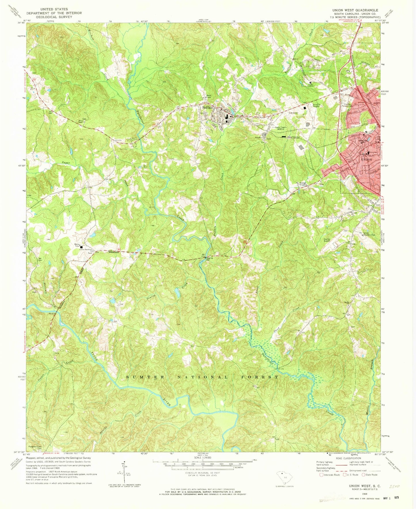
Historical USGS topographic quad map of Union West in the state of South Carolina. Typical map scale is 1:24,000, but may vary for certain years, if available. Print size: 24" x 27"
This quadrangle is in the following counties: Union.
The map contains contour lines, roads, rivers, towns, and lakes. Printed on high-quality waterproof paper with UV fade-resistant inks, and shipped rolled.
Contains the following named places: Dining Creek, Antioch Church, Buffalo Creek, Holcombe Branch, Mitchell Creek, Morris Branch, Saint Lukes Church, Sand Creek, Sparks Creek, Sugar Creek, Union Academy, Calhoun Experimental Forest, Sedalia Hunt Camp, Calhoun Experimental Forest, Fair Forest Hunt Camp, Fair Forest Rifle Range, Union County Fairgrounds, Buffalo, Antioch Church (historical), Bishop School (historical), Bishop Town (historical), Bobos Ford, Buffalo Baptist Church, Buffalo Cemetery, Buffalo Elementary School, Buffalo Mill Historic District, Buffalo United Methodist Church, Cedar Hill School (historical), Clinton Chapel Methodist Church (historical), Corinth Baptist Church (historical), Duncan Acres United Methodist Church, Fairforest Shoal, Gage School (historical), Gibbs Cemetery, Goat Alley, Harris Bridge, Holcombe Cemetery, Humphries Cemetery, Lower Fairforest Baptist Church Graveyard, Macbeth Church (historical), Minter Bridge (historical), Mud Bridge, Murphy Bridge, Murphy - Duncan Cemetery, Murphys Mill (historical), New Chapel Church (historical), Old Lower Fairforest Cemetery, Palmer Cemetery, Parks Cemetery, Rice Cemetery, Rice Cemetery, Saint Lukes School (historical), Sanders Cemetery, Sardis, Sardis United Methodist Church Graveyard, Sardis School (historical), South Street-South Church Street Historic District, Swink - Little Cemetery, Tempie Hill, Union City Hall, Union County Courthouse, Union County Jail, Union Square Shopping Center, Upper Rice Bridge, Wallace Cemetery, Weleyan Methodist Episcopal Church (historical), Westside Baptist Church, Wilburns School (historical), Cedar Hill School (historical), Union Country Club, Isaacs Creek, Lower Fairforest Baptist Church, Union Community Hospital (historical), Union Medical Center, Padgetts Creek Baptist Church Graveyard, Rices Chapel, Sardis United Methodist Church, Shoal Creek, West End School, Union County Airport Troy Shelton Field, E M M D Plant Heliport, Cedar Bluff Bridge, Bishops Church (historical), Buffalo Post Office, WBCU-AM (Union), West Springs Division, Buffalo Census Designated Place, Southside Fire Department, Buffalo Mill Fire Department, Buffalo Volunteer Fire Department, Union Public Safety Department, Union Public Safety Department - Police, Metro Care, Saint Luke Baptist Church Graveyard, Rice Chapel African Methodist Episcopal Zion Church Graveyard