MyTopo
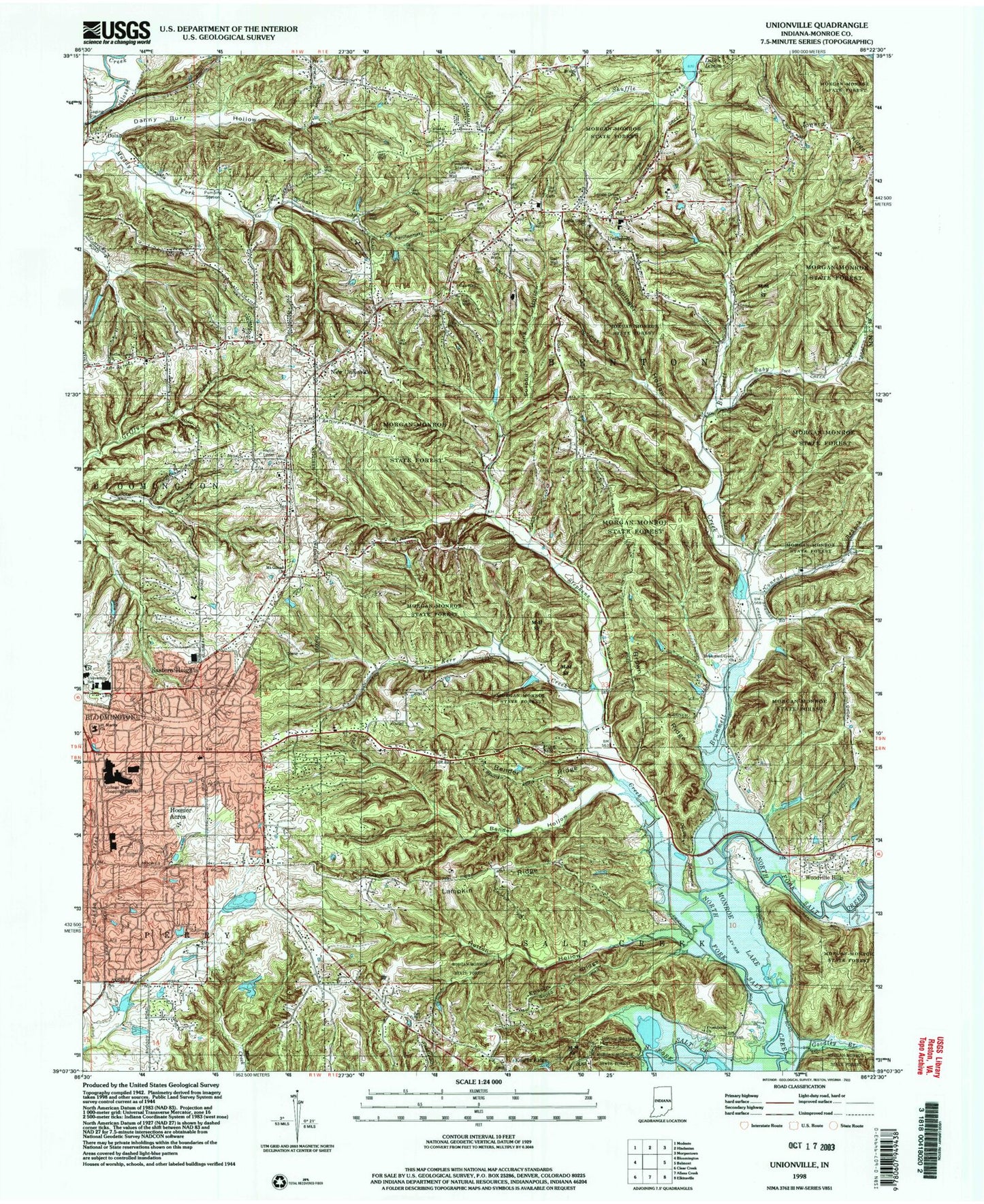
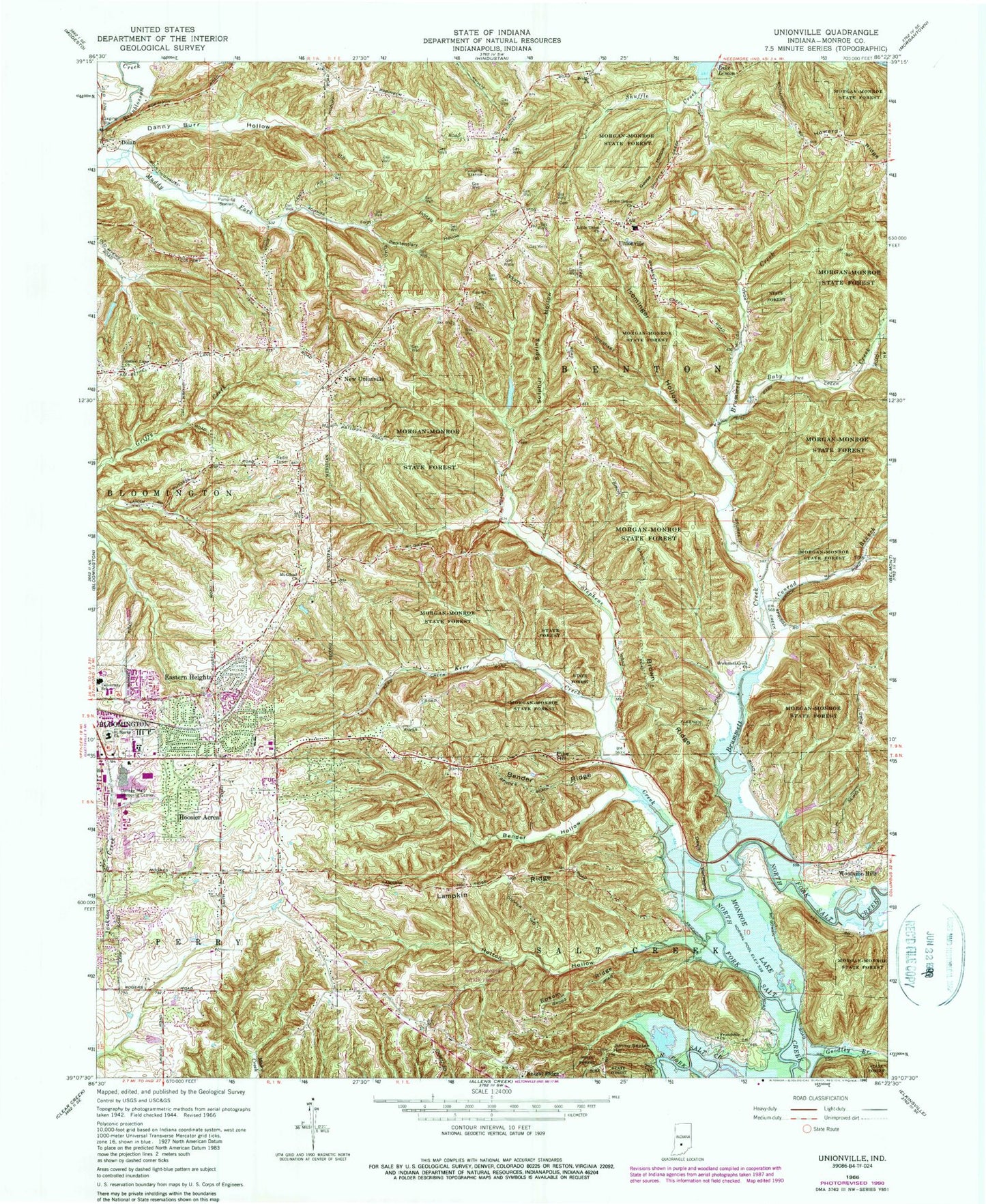
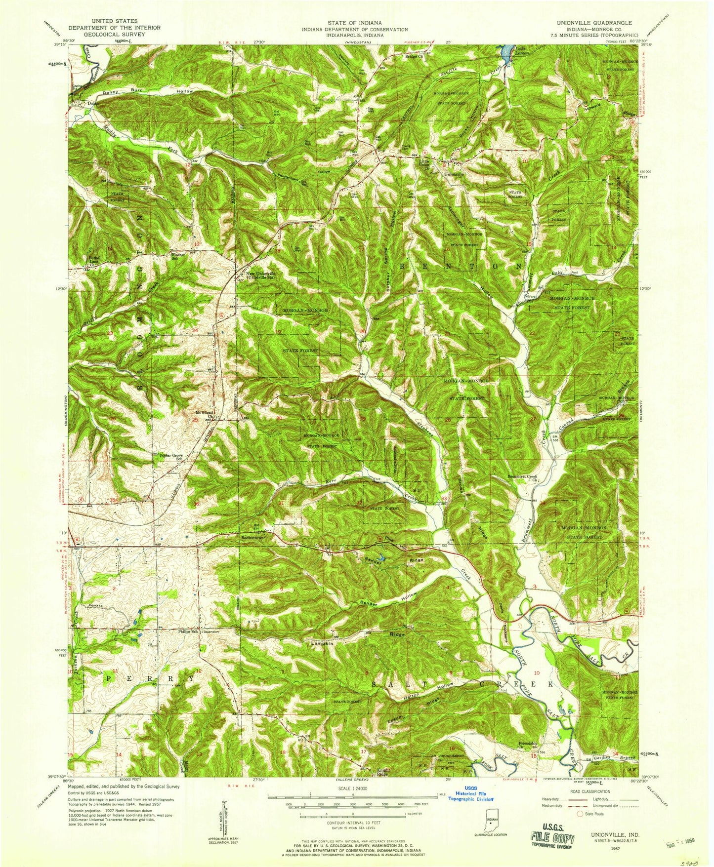
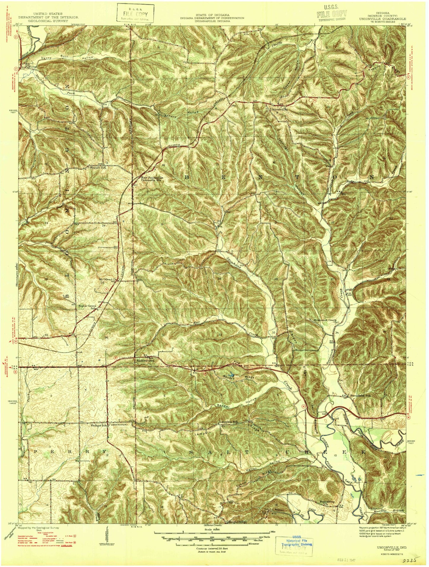
Classic USGS Unionville Indiana 7.5'x7.5' Topo Map
Couldn't load pickup availability
Historical USGS topographic quad map of Unionville in the state of Indiana. Typical map scale is 1:24,000, but may vary for certain years, if available. Print size: 24" x 27"
This quadrangle is in the following counties: Monroe.
The map contains contour lines, roads, rivers, towns, and lakes. Printed on high-quality waterproof paper with UV fade-resistant inks, and shipped rolled.
Contains the following named places: Baby Creek, Bender Hollow, Bender Ridge, Bethel Lane Church, Bridge Church, Brown Ridge, Brummett Creek, Brummett Creek Church, College Mall Shopping Center, Conrad Branch, Danny Burr Hollow, Devils Backbone, Dolan, Dolan Ridge Mission, Eastern Heights, Epsom Ridge, Friendship Church, Helton Hollow, Hoosier Acres, Isominger Hollow, Jimmy Sexton Hill, Kerr Creek, Knight Ridge, Lampkin Ridge, Little Union Church, Locust Grove Church, Mount Gilead Church, New Unionville, Penitentiary Hollow, Philips School, Pike Hill, Saint Marks Church, Shuffle Creek, Stephens Creek, Sulphur Spring Hollow, Unionville, Woodville Hills, Goose Hollow, WTIU-TV (Bloomington), Unionville Middle School, Unionville Elementary School, Schact Lake, Schacht Lake Dam, Bethal Lake, Bethal Lake Dam, WBWB-FM (Bloomington), WFIU-FM (Bloomington), Goodley Branch, Buzzard Roost Recreation Area, Township of Benton, Benton Township Volunteer Fire Department, Benton Township Volunteer Fire, Unionville Post Office, Woodbridge Post Office, Baby Creek, Bender Hollow, Bender Ridge, Bethel Lane Church, Bridge Church, Brown Ridge, Brummett Creek, Brummett Creek Church, College Mall Shopping Center, Conrad Branch, Danny Burr Hollow, Devils Backbone, Dolan, Dolan Ridge Mission, Eastern Heights, Epsom Ridge, Friendship Church, Helton Hollow, Hoosier Acres, Isominger Hollow, Jimmy Sexton Hill, Kerr Creek, Knight Ridge, Lampkin Ridge, Little Union Church, Locust Grove Church, Mount Gilead Church, New Unionville, Penitentiary Hollow, Philips School, Pike Hill, Saint Marks Church, Shuffle Creek, Stephens Creek, Sulphur Spring Hollow, Unionville, Woodville Hills, Goose Hollow, WTIU-TV (Bloomington), Unionville Middle School, Unionville Elementary School, Schact Lake, Schacht Lake Dam, Bethal Lake, Bethal Lake Dam, WBWB-FM (Bloomington), WFIU-FM (Bloomington), Goodley Branch, Buzzard Roost Recreation Area, Township of Benton, Benton Township Volunteer Fire Department, Benton Township Volunteer Fire, Unionville Post Office, Woodbridge Post Office, Baby Creek, Bender Hollow, Bender Ridge, Bethel Lane Church, Bridge Church, Brown Ridge, Brummett Creek, Brummett Creek Church, College Mall Shopping Center, Conrad Branch, Danny Burr Hollow, Devils Backbone, Dolan, Dolan Ridge Mission, Eastern Heights, Epsom Ridge, Friendship Church, Helton Hollow, Hoosier Acres, Isominger Hollow, Jimmy Sexton Hill, Kerr Creek, Knight Ridge, Lampkin Ridge, Little Union Church, Locust Grove Church, Mount Gilead Church, New Unionville, Penitentiary Hollow, Philips School, Pike Hill, Saint Marks Church, Shuffle Creek, Stephens Creek, Sulphur Spring Hollow, Unionville, Woodville Hills, Goose Hollow, WTIU-TV (Bloomington), Unionville Middle School, Unionville Elementary School, Schact Lake, Schacht Lake Dam, Bethal Lake, Bethal Lake Dam, WBWB-FM (Bloomington), WFIU-FM (Bloomington), Goodley Branch, Buzzard Roost Recreation Area, Township of Benton, Benton Township Volunteer Fire Department, Benton Township Volunteer Fire, Unionville Post Office, Woodbridge Post Office