MyTopo
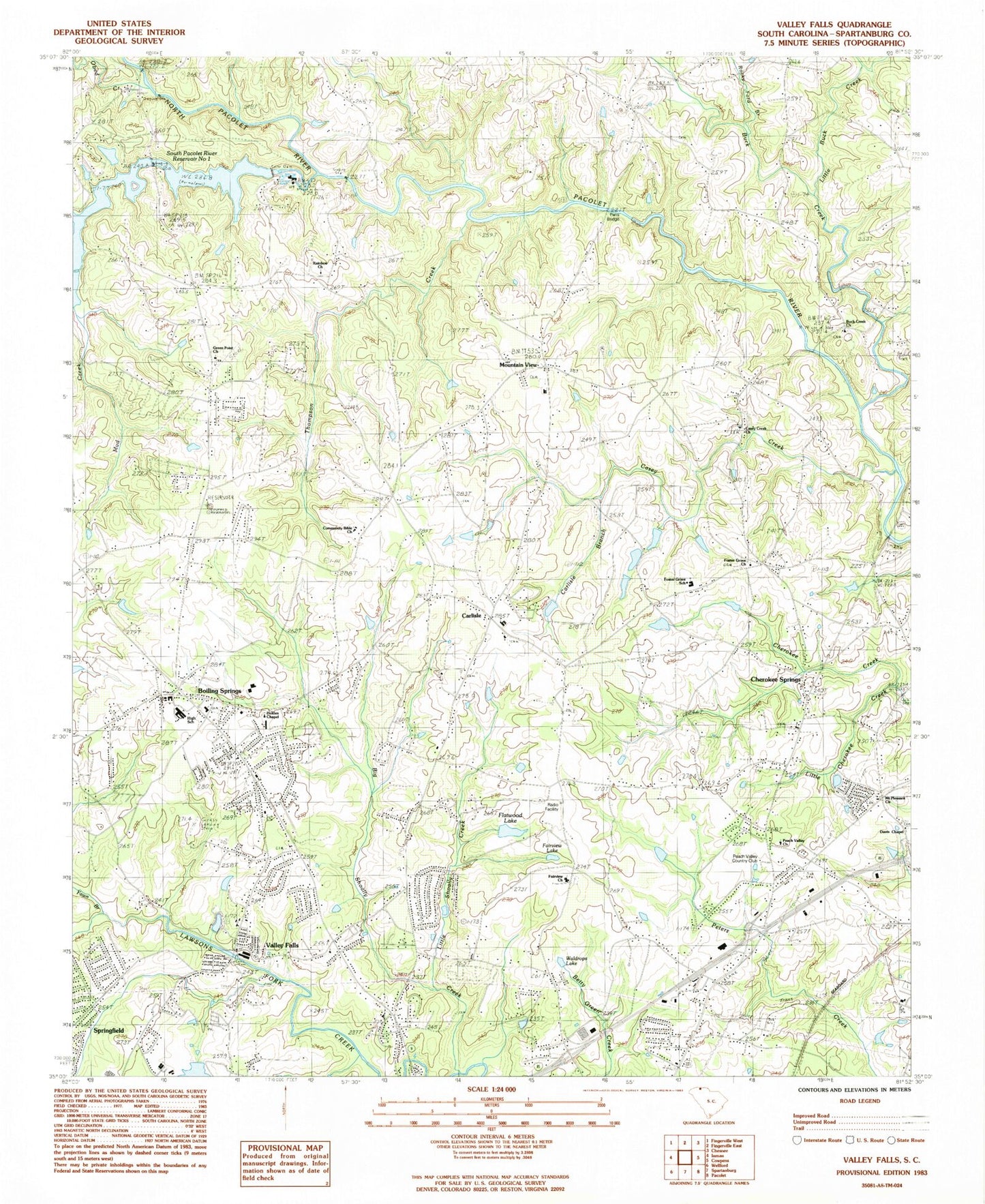
Classic USGS Valley Falls South Carolina 7.5'x7.5' Topo Map
Couldn't load pickup availability
Historical USGS topographic quad map of Valley Falls in the state of South Carolina. Typical map scale is 1:24,000, but may vary for certain years, if available. Print size: 24" x 27"
This quadrangle is in the following counties: Spartanburg.
The map contains contour lines, roads, rivers, towns, and lakes. Printed on high-quality waterproof paper with UV fade-resistant inks, and shipped rolled.
Contains the following named places: Buck Creek, North Pacolet River, Bethel Church, Big Shoally Creek, Boiling Springs, Carlisle Branch, Casey Creek, Fairview Lake, Fawn Branch, Flatwood Lake, Little Buck Creek, Little Cherokee Creek, Little Shoally Creek, Mount Pleasant Church, Mountain View, Mud Creek, Rainbow Lake, Waldrops Lake, Carlisle, South Pacolet River Reservoir Number One D-3324 Dam, South Carolina Noname 42013 Dam, A B Johnson Pond Dam D-3335, Tr Fawn Branch Pond Dam D-3329, Spring Lake Pond Dam D-3330, J C Petty Pond Dam D-3331, Tr Casey Creek Pond Dam D-3332, E W Nowland Pond Dam D-3333, Flatwood Lake Dam D-3334, Tr South Pacolet River Dam D-3323, Thomas Cantrell Pond Dam D-3258, Buck Creek Baptist Church, Casey Creek Baptist Church, Cherokee Springs, Cudds Creek, Davis Chapel, Fairview Baptist Church, Foster Grove School, Green Point Baptist Church, Holdens Chapel Baptist Church, Bells Mill (historical), Beverly Woods, Boiling Springs Elementary School, Boiling Springs First Baptist Church, Boiling Springs High School, Boiling Springs Junior High School, Boiling Springs Middle School, Buck Creek Baptist Church Graveyard, Buck Creek School (historical), Canterbury Heights, Carlisle Wesleyan Church Graveyard, Carlisle Elementary School, Carlisle Wesleyan Methodist Church, Casey Creek Cemetery, Cherokee Springs Baptist Church, Cherokee Springs Baptist Church Cemetery, Cherokee Springs School (historical), Clearview Heights, Community Bible Academy, Community Bible Church, Cothes Ford, Davis Chapel Wesleyan Church Graveyard, Ezell Cemetery, Ferndale, Fosters Grove Baptist Church, Fosters Grove, Green Point School (historical), Kentwood, Lakeview Manor, Laurelwood, Lenoir School (historical), Luray Hills, Lynwood, Mason Estates, McDowell Grove School (historical), McMillans Mill (historical), Meadow Spring, Midland Estates, Mountain View Baptist Church, Mountain View School (historical), Mountainbrook, North Hill Acres, North Hills, Northbrook Park, Northgate, Northwood, Pacolet School (historical), Panorama Estates, Peach Valley Baptist Church, Peach Valley Country Club, Peach Valley Fairway Estates, Peachtree Gardens, Peru School (historical), Quail Ridge, Rainbow Church, Sandy Ford Bridge, Sherman Park, Shoally Creek, Spring Hills, Springlake, Sunnydale Acres, Tabernacle Baptist Church, Thunderbird Mobile Home Park, Twin Creek, Woodcreek, Obed Creek, Paris Bridge, Rocky Ford Branch, South Pacolet River, Thompson Creek, Valley Falls, Pearson's Farm Airport, Valley Falls Baptist Church, Valley Falls Grade School (historical), Abbott Cemetery, Adventure Creek, Boiling Springs Division, Boiling Springs Census Designated Place, Valley Falls Census Designated Place, Rainbow Park, Diamond J Mobile Home Park, McGreegor Downs, Thorn Ridge Mobile Home Park, Boiling Springs Fire Department Headquarters, Cherokee Springs Fire Department, Boiling Springs Fire Department Station 2, Cherokee Springs Fire Department Station 2, Mayo Fire Department Substation, Persimmon Creek, Fosters Grove Baptist Church Graveyard, Mount Pleasant Baptist Church Graveyard, View Church Graveyard, Fairview Baptist Church Graveyard, Holden Chapel Missionary Baptist Church Graveyard, Boiling Springs First Baptist Church Cemetery, Christ United Methodist Church Cemetery, Good Shepherd Memorial Park Cemetery, Boiling Springs Memorial Gardens