MyTopo
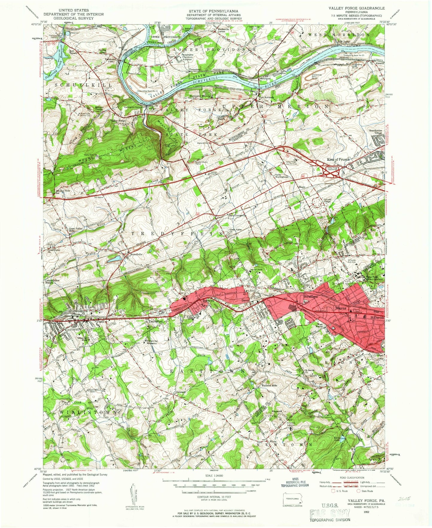
Classic USGS Valley Forge Pennsylvania 7.5'x7.5' Topo Map
Couldn't load pickup availability
Historical USGS topographic quad map of Valley Forge in the state of Pennsylvania. Typical map scale is 1:24,000, but may vary for certain years, if available. Print size: 24" x 27"
This quadrangle is in the following counties: Chester, Delaware, Montgomery.
The map contains contour lines, roads, rivers, towns, and lakes. Printed on high-quality waterproof paper with UV fade-resistant inks, and shipped rolled.
Contains the following named places: Abrahams Run, Aronwold, Berwyn, Caley Road School, Camp Run, Cathcart Home, Cedar Hollow Station, Church of the Good Samaritan, Colonial Village, Conestoga High School, Daylesford, Devereux Foundation School, Devon, Diamond Rock School, Earles Lake, Emmanuel Church, General Wayne Junior High School, Great Valley Church, Great Valley Church, Great Valley Mills, Green Tree, Impounding Basin Number Twenty-One, Impounding Basin Number Twenty-Two, Impounding Basin Number Twenty-Four, Impounding Basin Number Twenty-Five, Indian Creek, Jug Hollow, Julip Run, King of Prussia, Leopard, Little Darby Creek, Little Valley Creek, Memorial Arch, Miles Run, Mount Zion Church, Old Union Church, Our Lady of Assumption School, Paoli, Pawling Chapel, Pickering Creek Reservoir, Port Indian, Saint Davids, Saint Davids Church, Saint Gabriel Hall, Saint Katherines School, Saint Matthews Church, Saint Monica Cemetery, Saint Teresa School, School for the Blind, Star Redoubt Number One, Strafford, Trout Creek, Valley Creek, Valley Forge, Valley Forge Middle School, Valley Forge Military Academy, Valley Meetinghouse, Washington Memorial Church, Wayne, Wayne Elementary School (historical), West Wayne, Wetherills Corner, Wetherills Dam, Wigwam Run, Wyola, Mount Joy, Mine Run, Mount Misery, Perkiomen Creek, Hobson Airport (historical), Lake Green Countrie, Green Countrie Dam, Club Lake, Mill Club Dam, Martins Dam, Oaks Dam, Pickering Creek Dam, Duffryn Mawr, Garden, Rennyson, Chester Valley Post Office (historical), Paoli Road, Maple (historical), Martins Dam, French Dam, WIFI-FM (Philadelphia), Elliotts Run, Thomas Run, Saw Mill Run, Lewis Run, Valley Creek Gorge, Valley Forge Trailer Park, Lafayette Park, Cannon Run West, Crestwyck, Sweet Briar, Hidden Valley, Washington Park, Cannon Run, Abrahams, Betzwood, Brittains Corner, Bull Tavern, Howellville, New Centerville, Perkiomen Junction, Waterloo Mills, Valley Forge Bicentennial Heliport, Valley Forge Center, King of Prussia Plaza, Wayne Station, Eagle Station, Radnor Middle School, Port Kennedy Quarry, Tredyffrin / Easttown Middle School, Wetherills Cemetery, Betzwood Bridge (historical), Home of John Audubon, Valley Forge Corporate Center, King of Prussia Industrial Park, General Electric Space Center, Court at King of Prussia, Abrams Station, Entrekin Dam, Mill Club Dam, George H Earle Junior Dam, Crow Creek, Upper Marion High School, Upper Marion Middle School, Paoli Shopping Center, Valley Forge National Historical Park, Gulph Station, King of Prussia Station, Philadelphia Protectory for Boys, Betzwood Station, Aronimink Golf Club, General Wayne Statue, Phoenixville Country Club, Saint Davids Golf Club, Valley Forge Country Club, Washington Headquarters, Foxcatcher Heliport, Benson Heliport, Peco Berwyn Heliport, Crouse Heliport, Beaumont Elementary School, Devon Elementary School, Hillside Elementary School, New Eagle Elementry School, Roberts Elementary School, Valley Forge High School, Gateway Shopping Center, Township of Easttown, Township of Schuylkill, Township of Tredyffrin, Township of Willistown, Township of Upper Merion, East Branch Crum Creek, Evans Run, Fox Run, Green Tree Run, Grubb Mill Run, Waynesborough Run, Chesterbrook, Fort Washington (historical), Crabby Creek, Bruckmann Chapel of Saint Joseph, Cabrini Apartment Complex, Dixon Center, Emmaus House, Lanshe House, New Science Education Technology Building, Sullivan House, The Mansion, Gym Cottage, Beidler Knoll, Berwyn Fire Company Station 2, Berwyn Shopping Center, Berwyn Station, Betzwood Marina, Betzwood Park, Blackburn Farm, Colonial Way, Buttonwood Farms, Chapel View Estates, Chesterbrook Academy, Abrams Community Chapel, American Baptist and Freedom Business Center, Harrison Estate, Continental Arms, Court and the Plaza Shopping Center, David Estates, Daylesford Lake, Daylesford Station, Deepdale, Devereux Gateway School, Devereux Preparatory School, Devon Hunt, Devon Post Office, Devon Prepatory School, Devon Station, Dubarry Estates, Easttown Township Building, Easttown Township Library, Easttown Township Police Department, Easttown YMCA, Episcopal Academy Devon Campus, First Presbyterian of Port Kennedy Church, Freedom View, General Wayne Elementary School, Glen Craig, Glen Hardie, Glenhardie Golf Course, Glenn Rose, Great Valley Presbyterian Cemetery, Green Countrie Village, Leopard Farms, Leopard Lakes, Lexton Woods, Mainline United Methodist Church, Martins Dam Bridge, Meadows at Valley Forge, Memorial of Radnor Township Library, Mill Grove Museum of John Audubon, Montgomery County Sewage Disposal Plant, Moteer School, Mother Divine Providence School, Mother of Divine Providence School, Jenkins Arboretum, Kerwood, King of Prussia Business Center, King of Prussia Chamber of Commerce, King of Prussia Church of Christ, King of Prussia Library, King of Prussia Mall Shopping Center, King of Prussia Fire Company Station 47