MyTopo
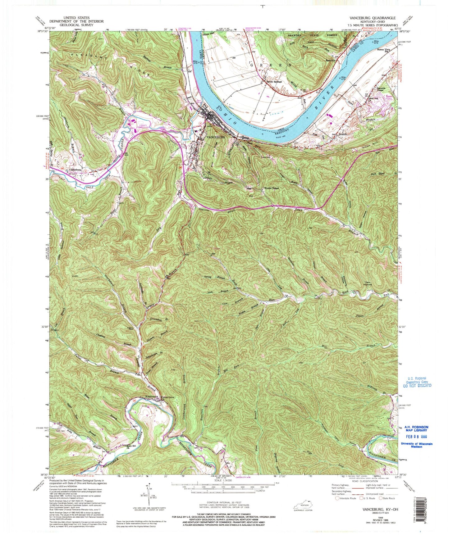
Classic USGS Vanceburg Kentucky 7.5'x7.5' Topo Map
Couldn't load pickup availability
Historical USGS topographic quad map of Vanceburg in the states of Kentucky, Ohio. Map scale may vary for some years, but is generally around 1:24,000. Print size is approximately 24" x 27"
This quadrangle is in the following counties: Adams, Lewis, Scioto.
The map contains contour lines, roads, rivers, towns, and lakes. Printed on high-quality waterproof paper with UV fade-resistant inks, and shipped rolled.
Contains the following named places: Adams Cemetery, Alum Rock Ridge, Appletree Branch, Axehandle Branch, Backbone Hollow, Black Oak Church, Black Oak Volunteer Fire Department, Blue Spring Branch, Buck Lick, Buena Vista, Buena Vista Cabin Railroad Station, Buena Vista Station, Cassidy Hollow, Cat Branch, Chestnut Branch, City of Vanceburg, Clarksburg, Clarksburg Branch, Clay Lick, Coon Branch, Crumbs Landing, Dravo Railroad Station, Dry Run, Dyer Branch, Evans Cemetery, Evans Chapel, Ewings Landing, Finger Board Hollow, First Import Route for Horses Historical Marker, Fish Gut Branch, Fly Branch, Fly Branch School, Fuller Branch, Gander Branch, Gilpen Run, Grassy Branch, Griffin Hollow, Groundhog Branch, Gunnel Branch, Hamilton Branch, Hazel Branch, Holly Branch, Holly Cemetery, Holly Hill Church, Irish Bottom, Jesse Grants Tanyards Historical Marker, Kennedys Bottom, Kinniconick, Kinniconick Post Office, Leatherwood Branch, Lewis County Fairgrounds, Lewis County Historical Marker, Lewis County Infirmary, Lewis County Sheriff's Office, Lewis County Volunteer Fire Company, Machine Branch, Matthews Branch, McCall Cemetery, McCall Run, McCalls Landing, McKinleys Landing, Mill Fork, Miller Branch, Neds Branch, Nolan Hollow, Ohio State Park, Pigpen Branch, Powers Landing, Puncheon Camp Hollow, Randville Post Office, Red Fox Landing, Reynolds Chapel, Rock Run, Rock Run School, Rockville, Salt Lick Creek, Salt Lick Landing, Sand Branch, Sandy Springs, Sandy Springs Cemetery, Sandy Springs Landing, Sandy Springs Post Office, Schoolhouse Branch, Shepherd Branch, Slate Hollow, Slate Point, Spring Branch, Sugar Tree Branch, Thomas Branch, Town Branch School, Trout Branch, Twin Hollows, Union Hill, Union Memorial Historical Marker, V A Cabin Railroad Station, Vanceburg, Vanceburg Division, Vanceburg Police Department, Vanceburg Post Office, Vanceburg Volunteer Fire Department, Vanceburg Volunteer Fire Department Station 2, Walnut Grove Church, Wesley Branch, WKKS-AM (Vanceburg), WKKS-FM (Vanceburg)