MyTopo
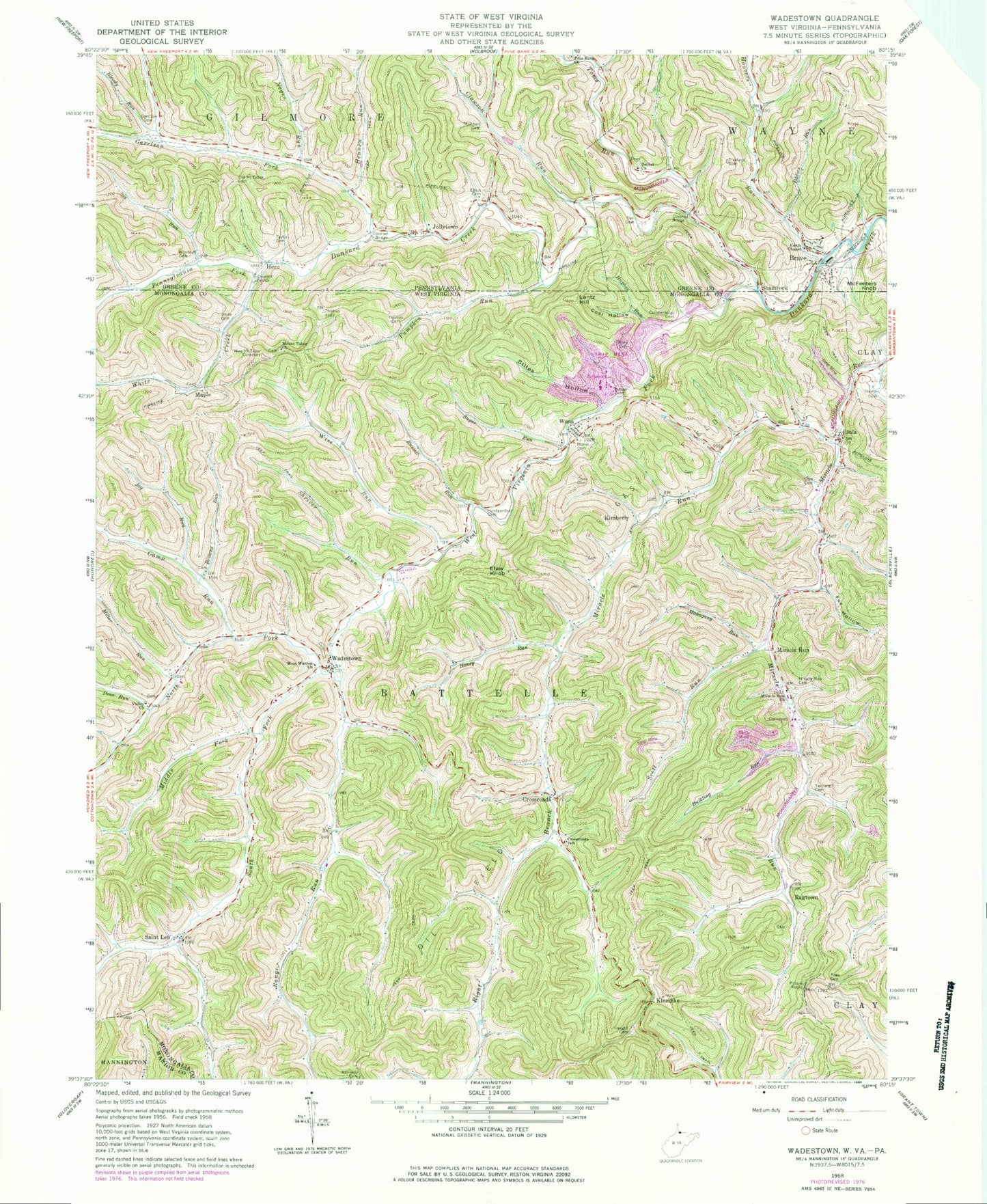
Classic USGS Wadestown West Virginia 7.5'x7.5' Topo Map
Couldn't load pickup availability
Historical USGS topographic quad map of Wadestown in the states of West Virginia, Pennsylvania. Map scale may vary for some years, but is generally around 1:24,000. Print size is approximately 24" x 27"
This quadrangle is in the following counties: Greene, Marion, Monongalia.
The map contains contour lines, roads, rivers, towns, and lakes. Printed on high-quality waterproof paper with UV fade-resistant inks, and shipped rolled.
Contains the following named places: Barr School, Battelle, Bethel Church, Bethel Church Cemetery, Blacksville Number 2 Mine, Blacksville Number Two Fresh Water Dam, Blacksville Number Two Refuse Bank Dam, Bloody Run, Brave, Brave Census Designated Place, Brave Post Office, Brave Station, Browns Run, Building Run, Bula, Bula Baptist Church, Camp Run, Camp Run School, Clawson Run, Coal Hollow, Core Cemetery, Cross Cemetery, Crossroads, Crossroads School, Cumberledge Cemetery, Dye Cemetery, Eakin Cemetery, Eddies Run, Efaw Knob, Federal Number 1 Mine, Federal Number 2 Mine, Fox Hollow, Freeland Cemetery, Garrison Cemetery, Garrison Fork, Grace Fellowship Southern Baptist Church, Handgardner Cemetery, Haught Cemetery, Hennen Run, Hero, Honey Run, Hoovers Run, Hughes Run, Hunting Hills, Jackson Spring, Jollytown, Joy Run, Kennedy Cemetery, Kents Chapel, Kimberly, Klondike, Lantz Hill, Mahogany Run, Maple, Mason - Dixon Elementary School, McFeeters Knob, Meighen Cemetery, Middle Fork West Virginia Fork Dunkard Creek, Miller Run, Miracle Run, Miracle Run Cemetery, Miracle Run United Methodist Church, Morris Cemetery, Mount Tabor Cemetery, Mount Tabor United Methodist Church, Negro Run, Negro Run Cemetery, North Fork West Virginia Fork Dunkard Creek, Old Mount Tabor Cemetery, Pennsylvania Fork Dunkard Creek, Piles Cemetery, Pond Number Two, Pone Run, Pumpkin Run, Ragtown, Range Run, Ray Tuttle Spring, Right Branch Miracle Run, Russell Run, Saint Leo, Saint Leo Methodist Church, Sanford Cross Spring, School Number 1, Scott Run, Shamrock, Shriver Run, Six Run, South Fork West Virginia Fork Dunkard Creek, Stiles Hollow, Stiles Run Dam, Sugar Run, Taber School, Taylor Cemetery, Tennant Cemetery, Tennant School, Thomas Cemetery, Thomas Run, Toms Run, Township of Gilmore, Truth Assembly Chapel, Union Baptist Church, Union School, Upper Buffalo Creek Structure Number 39 Dam, Valley Chapel United Methodist Church, Valley School, Wadestown, Wadestown Elementary School, Wadestown Post Office, Wadestown United Methodist Church, Wadestown Volunteer Fire Department, Wana, Wana Post Office, Wana United Methodist Church, Wayne Township Volunteer Fire Department Company 75, West Virginia Fork Dunkard Creek, West Warren Church, White Creek, Whites Reunion and Cemetery, Wiley Cemetery, Wilson Cemetery, Wise Run, Woodruff Cemetery, Zeb Haught Spring, ZIP Codes: 15316, 26590