
MyTopo
Classic USGS Walton Nebraska 7.5'x7.5' Topo Map
Couldn't load pickup availability
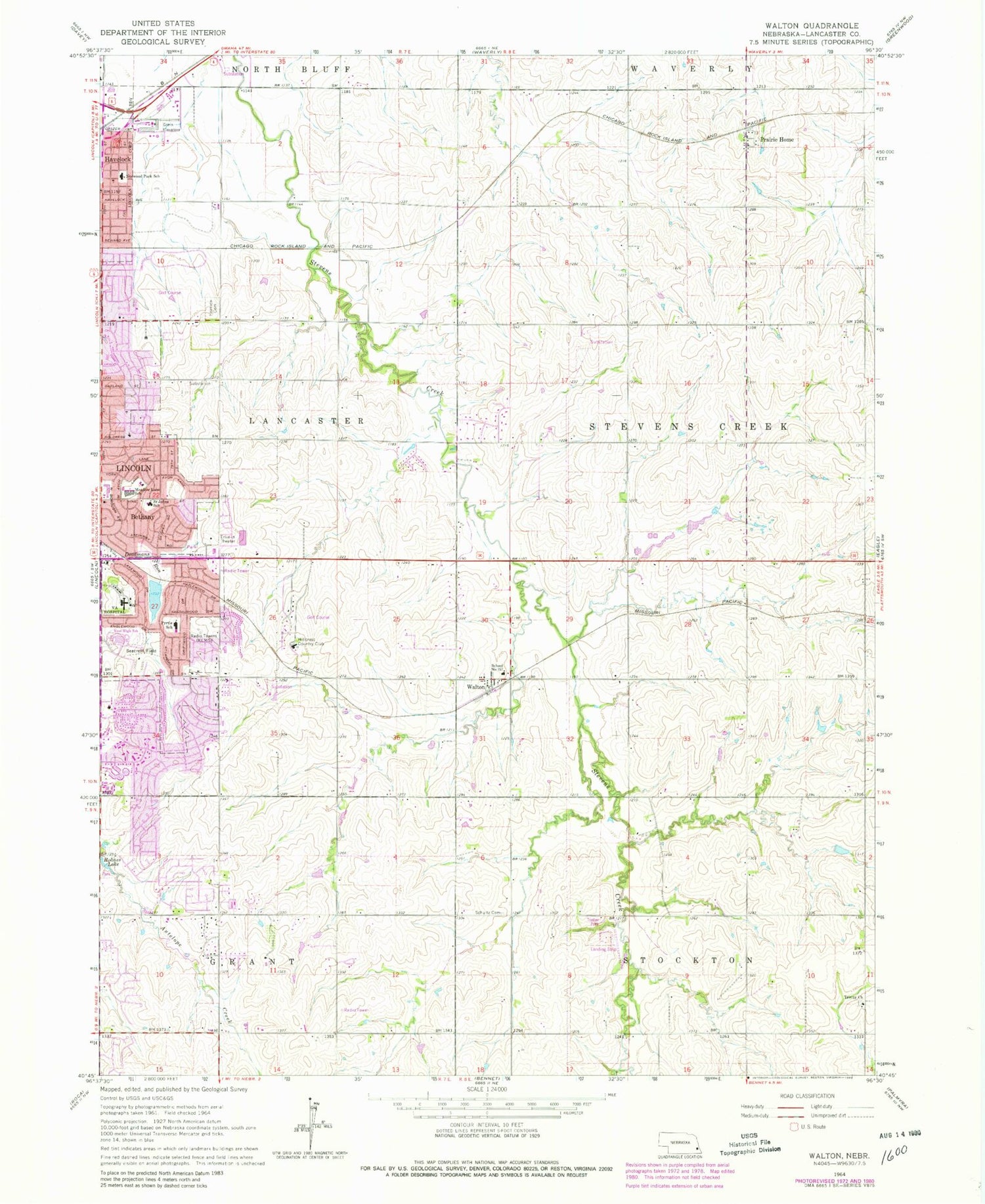
Historical USGS topographic quad map of Walton in the state of Nebraska. Map scale may vary for some years, but is generally around 1:24,000. Print size is approximately 24" x 27"
This quadrangle is in the following counties: Lancaster.
The map contains contour lines, roads, rivers, towns, and lakes. Printed on high-quality waterproof paper with UV fade-resistant inks, and shipped rolled.
Contains the following named places: Aldersgate United Methodist Church, All Saints Lutheran Church, Bethany - University Park Kingdom Hall of Jehovahs Witnesses, Bethel Baptist Church, Beverly Health and Rehabilitation Center, Calvary Baptist Church, Canoyer Country Greenhouses, Capitol City Church of Christ, Community Christian Church of Christ, Crestwood Christian Church, Crooked Creek Golf Course, Dan Hartog Baseball Field, David H Murdock Trail, Dialysis Center of Lincoln, East Lincoln Christian Church, Eastside Church of Christ, Eighty-Fourth Street Trail, Fairview Cemetery, Faith Bible Church, Faith Lutheran School, Family Dentistry Center, Farmers Cooperative Company Elevator, Fellowship Community Church, Firethorn Golf Club, First Evangelical Free Church, First Mennonite Church, Garden View Church, Good Shepherd Presbyterian Church, Greenwood Farmers Cooperative Elevator, Herbert Park, Hillcrest Country Club, HiMark Golf Course, Indian Hills Community Church, Jan Pad Heliport, Jaycee-Kahoa Park, Jones Dam, Jones Reservoir, Kahoa Elementary School, KFMQ-AM (Lincoln), Lancaster Election Precinct, Lincoln Christian School, Lincoln East High School, Lincoln Family Medical Group Center, Lincoln Fire and Rescue Station 12, Lincoln Spanish Seventh Day Adventist Church, Lincoln Surgical Hospital, Lux Middle School, Mahoney Golf Course, Mahoney Park, Maxey Elementary School, Meadow Lane Elementary School, Messiah Lutheran Church, Messiah Lutheran School, Monahan Dam, Monahan Reservoir, Mount Olive Evangelical Lutheran Church, New Covenant Baptist Church, North Forty Golf Complex, Northside Seventh Day Adventist Church, Norwood Park Elementary School, Pester Airport, Prairie Creek, Prairie Creek Lake, Prairie Home, Prairie Home Census Designated Place, Prairie Home Post Office, Pyrtle Elementary School, Rosemont Alliance Church, Saint Andrews Lutheran Church, Saint Davids Episcopal Church, Saint Elizabeth Wound Care Center, Saint John School, Saint John the Apostle Catholic Church, Saint Joseph School, Saint Josephs Catholic Church, Saint Marks United Methodist Church, School Number 157, Schultz Cemetery, Seacrest Field, Seacrest Park, Seacrest Park Trail, Second Church of Christ Scientist, Shanda Dixon Bikeway Trail, Shirleys Station Post Office, Southeast Community College, Southeast Rural Fire District - Holdrege Station, Stevens Creek Election Precinct, Sunrise Park, Township of Lancaster, Township of Stevens Creek, Trendwood Park, Trendwood Park Trail, University of Nebraska Experimental Farm, VA Nebraska - Western Iowa Health Care Outpatient Clinic, VA Nebraska - Western Iowa Health Care System - Lincoln, Vietnamese Alliance Church, Walton, Walton Census Designated Place, Walton Post Office, Wedgewood Lake, Wedgewood Lake Dam, Wedgewood Medical Center, YMCA Spirit Park, ZIP Codes: 68461, 68505, 68507, 68520, 68527


