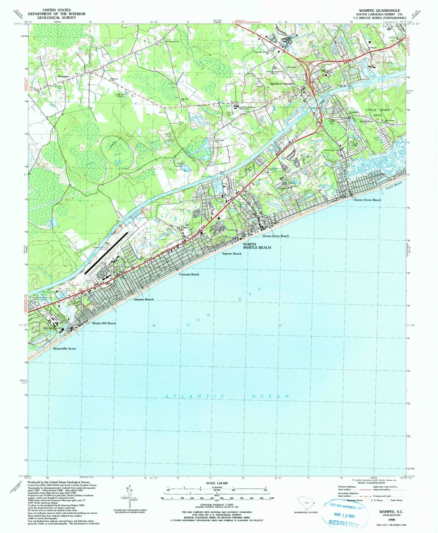
MyTopo
Classic USGS Wampee South Carolina 7.5'x7.5' Topo Map
Couldn't load pickup availability
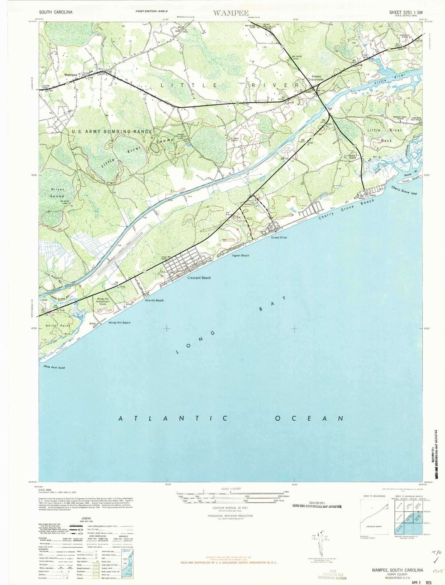
Historical USGS topographic quad map of Wampee in the state of South Carolina. Map scale may vary for some years, but is generally around 1:24,000. Print size is approximately 24" x 27"
This quadrangle is in the following counties: Horry.
The map contains contour lines, roads, rivers, towns, and lakes. Printed on high-quality waterproof paper with UV fade-resistant inks, and shipped rolled.
Contains the following named places: Airport Lagoon, Airport Lagoon Dam D-3636, Atlantic Beach, Atlantic Beach Police Department, Atlantic Beach Town Hall, Azalea Sands Golf Course, Bay Forest, Bay Tree Golf Plantation, Beachwood Golf Club, Belle Park, Briarcliffe Acres, Briarcliffe Acres Police Department, Camp Branch Run, Camp Nixon, Cedar Creek Cemetery, Cedar Creek Village, Central Park, Chapel by the Sea, Cherry Grove Beach, Cherry Grove Beach Post Office, Cherry Grove Inlet, Church of God, Coastal Christian Center, Coastal Post Office, Coquina Harbor, Coquina Harbour, Creekside, Crescent Beach, Eastport Golf Course, First Baptist Church, Forest Lake, Forest Lawn Cemetery, Gator Hole Golf Course, George R Vereen Wastewater Treatment Plant, Golf View Plantation, Grand Strand Airport, Harbourgate Resort and Marina, Heritage Shores, Hollywood, Horry County Fire Department Station 32, Horry County Fire Department Station 5, House Creek, Ingram Beach, J Bryan Floyd Community Center, King of Glory Lutheran Church, Kingswood, Lake Side Church, Lakeside Baptist Church, Landmark Church, Lewis Pond, Lewis Pond Dam D-3635, Little River Division, Little River Neck School, Little River Post Office, Little River School, Little River Swamp, Macedonia Church, McLean Park, McLeod Health Seacoast, Mount Pleasant Church, Mount Zion Church, Mount Zion School, Nixon Creek, Nixons Crossroads, North Myrtle Beach, North Myrtle Beach Assembly of God Church, North Myrtle Beach City Hall, North Myrtle Beach Community Center, North Myrtle Beach Crescent Beach Wastewater Treatment Facility, North Myrtle Beach Elementary School, North Myrtle Beach Fire Rescue Department Station 1, North Myrtle Beach Fire Rescue Department Station 2 Cherry Grove, North Myrtle Beach Fire Rescue Department Station 3 Windy Hil, North Myrtle Beach Fire Rescue Department Station 5 Barefoot Resort, North Myrtle Beach High School, North Myrtle Beach Memorial Gardens, North Myrtle Beach Middle School, North Myrtle Beach Ocean Drive Wastewater Treatment Facility, North Myrtle Beach Pentecostal Church, North Myrtle Beach Police Department, North Myrtle Beach Post Office, North Myrtle Beach Primary School, North Myrtle Beach Rescue, North Strand Plaza Shopping Center, Ocean Drive Beach, Ocean Drive Church, Old River Estates, Open Door Church, Our Lady Star of the Sea Church, Palmetto Shores, Pinewood Acres, Pleasant Meadow Church, Poplar School, Possum Trot Golf Club, Prices Swamp, Prices Swamp Run, Princeton Place, Risen Christ Lutheran School, River Hills Golf and Country Club, Robbers Roost Golf Club, Robbers Roost Villas, Saint Delight Church, Saint Joseph Church, Saint Paul Church, Saint Stephens Church, Salt Flat Creek, Sherwood Forest Campground, Southeastern Memorial Gardens, Summit Place of North Myrtle Beach, Surf Golf and Beach Club, Surfwood Shopping Center, The Grove, Tilghman Estates, Timber Ridge, Town of Atlantic Beach, Town of Briarcliffe Acres, Trinity Church, Trinity United Methodist Church, Union Valley Church, Village at Bay Tree, Wampee, Wampee Church, Wampee Fire Lookout Tower, Wampee School, White Point, White Point Swash, Williams Creek, Windy Hill Antiaircraft Camp, Windy Hill Beach, ZIP Codes: 29566, 29582