MyTopo
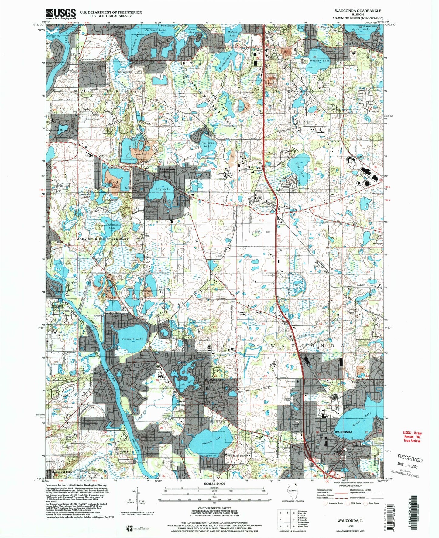
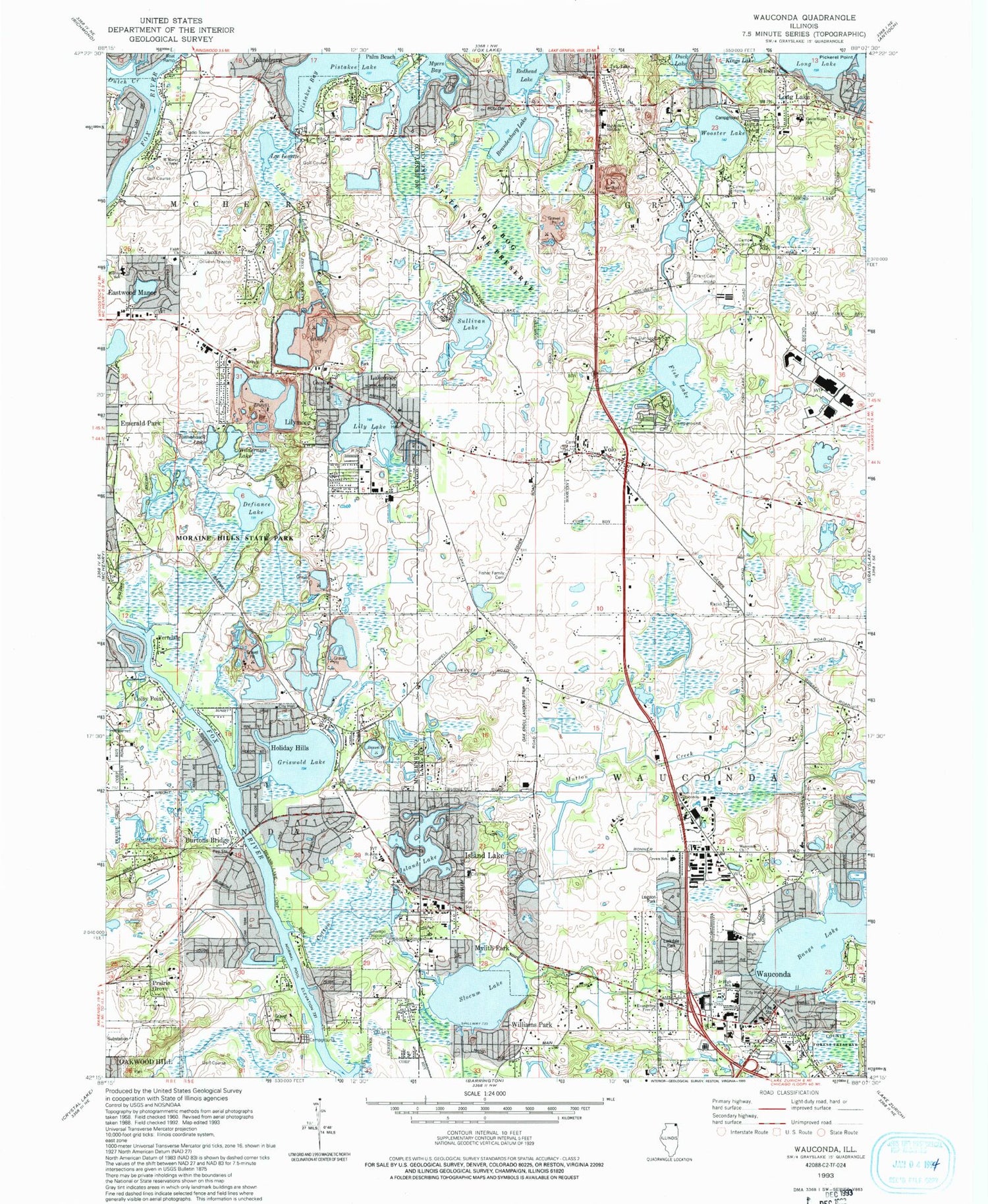
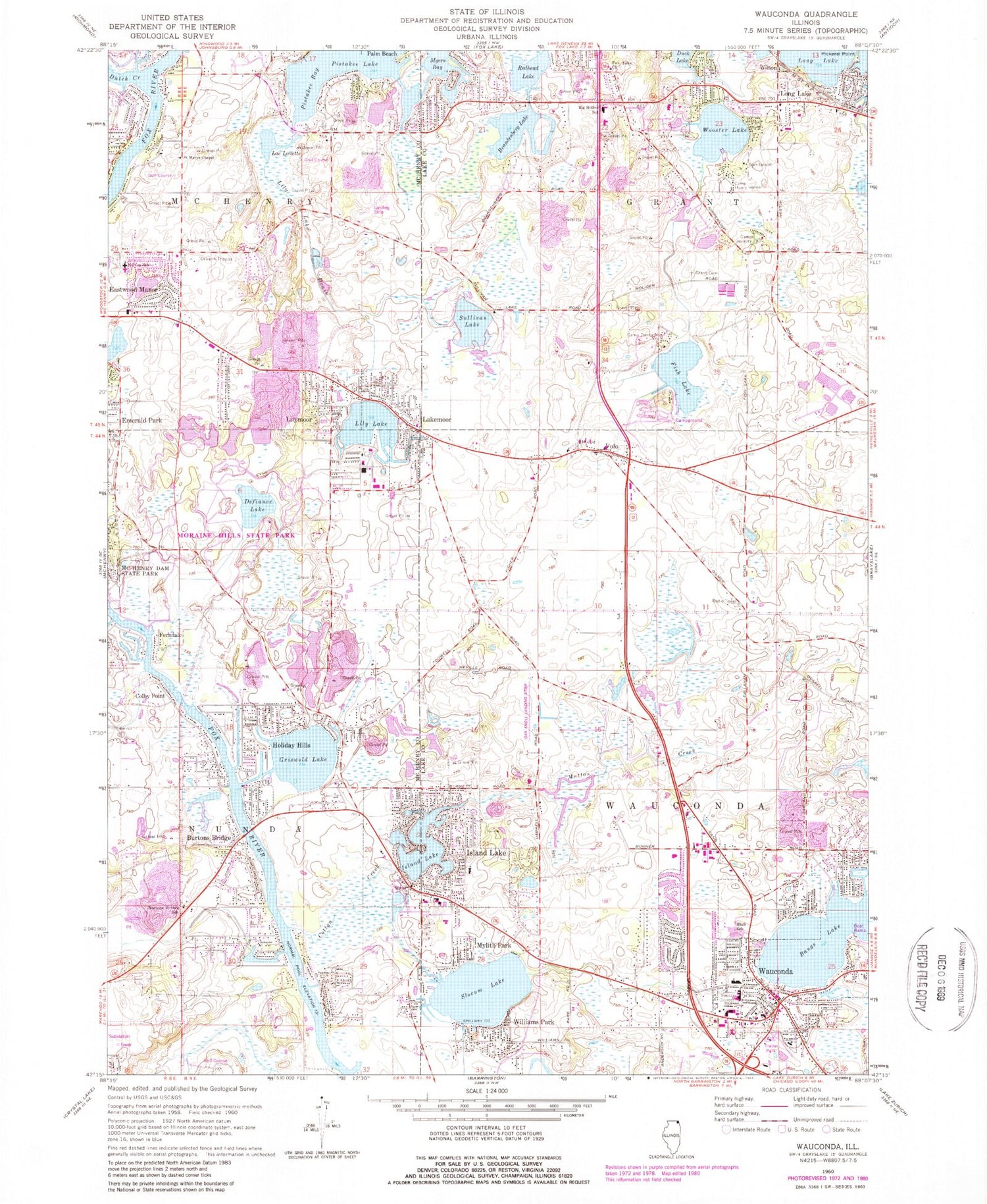
Classic USGS Wauconda Illinois 7.5'x7.5' Topo Map
Couldn't load pickup availability
Historical USGS topographic quad map of Wauconda in the state of Illinois. Map scale may vary for some years, but is generally around 1:24,000. Print size is approximately 24" x 27"
This quadrangle is in the following counties: Lake, McHenry.
The map contains contour lines, roads, rivers, towns, and lakes. Printed on high-quality waterproof paper with UV fade-resistant inks, and shipped rolled.
Contains the following named places: Bangs Lake, Big Hollow Elementary School, Big Hollow Middle School, Brandenburg Lake, Brefield School, Brick School, Burton Bridge, Burtons Bridge, Burtons Bridge Census Designated Place, Burtons Bridge School, Camp Duncan, Camp Henry Horner, Camp Hickory, Chapel Hill Country Club, Colby Point, Cook Memorial Park, Cotton Creek, Cotton Creek Marsh, Cotton Creek Marsh Nature Preserve, Defiance Lake, Dutch Creek, Eastwood Manor, Emerald Park School, Evangelical Free Church, Faith Presbyterian Church, Federated Church of Wauconda, Ferndale, First Church of Christ Scientist, First United Pentecostal Church, Fish Lake, Fisher Family Cemetery, Fox Lake Baptist Church, Fox Lake Fire Department Station 3, Fox River Shores, Fox River Trail, Gavin South Junior High School, Glynch School, Golden Oaks Farm, Grant Cemetery, Griswold Lake, Griswold Lake School, Hickory Ridge Day Use Area, Hilltop Elementary School, Holiday Hills, Holiday Hills City Hall, Indian Ridge County Park, Island Lake, Island Lake City Hall, Island Lake Dam, Island Lake Post Office, Island Lake Village Police Department, Kettle Moraine Nature Preserve, Kettle Woods Day Use Area, Lac Louette, Lagoon Park, Lake Defiance Day Use Area, Lake Defiance Nature Trail, Lake Defiance Trail, Lakemoor, Lakemoor City Hall, Lakemoor Police Department, Lakewood County Forest Preserve, Larkdale Park, Leather Leaf Bog Trail, Leatherleaf Bog, Lily Lake, Lily Lake Drain, Lily Lake School, Lilymoor, Lincoln School, Long Lake, McHenry - Nunda Township Public Library, McHenry Township Fire Protection District Station 3, Moraine Hills State Park, Mutton Creek, Myers Bay, Mylith Park, Northern Lakes Day Use Area, Nunda Rural Fire Protection District, Oak Knoll Farm Airport, Oakwood Hills Fen Nature Preserve, Park Lane Nature Park, Pike Marsh, Pike Marsh Day Use Area, Pine Hills Day Use Area, Pistakee Bay, Pistakee Bog Nature Preserve, Pistakee Golf Course, Prairie Isle Golf Club, Redhead Lake, Robert Crown Elementary School, Roseville School, Saint John Lutheran Church, Saint Marys Chapel, Saint Peter Cemetery, Saint Peters Church, Slocum Lake, Slocum Lake School, Sullivan Lake, Tamarack View Trail, Tomahawk Lake, Township of Grant, Township of Wauconda, Transfiguration Church, Transfiguration School, Village of Holiday Hills, Village of Island Lake, Village of Lakemoor, Village of Volo, Village of Wauconda, Volo, Volo Bog, Volo Bog Interpretive Trail, Volo Bog State Nature Preserve, Volo Cemetery, Warrior Marsh, Wauconda, Wauconda Area Public Library, Wauconda Baptist Church, Wauconda Cemetery, Wauconda City Hall, Wauconda Community High School, Wauconda Elementary School, Wauconda Fire Department Station 1, Wauconda Fire Department Station 2, Wauconda Fire Department Station 3, Wauconda Middle School, Wauconda Post Office, Wauconda Village Police Department, Whitetail Prairie Day Use Area, Wilderness Lake, Wilderness Lake Day Use Area, Williams Park, Wilson, Wooster Lake, ZIP Codes: 60041, 60042, 60051, 60084