MyTopo
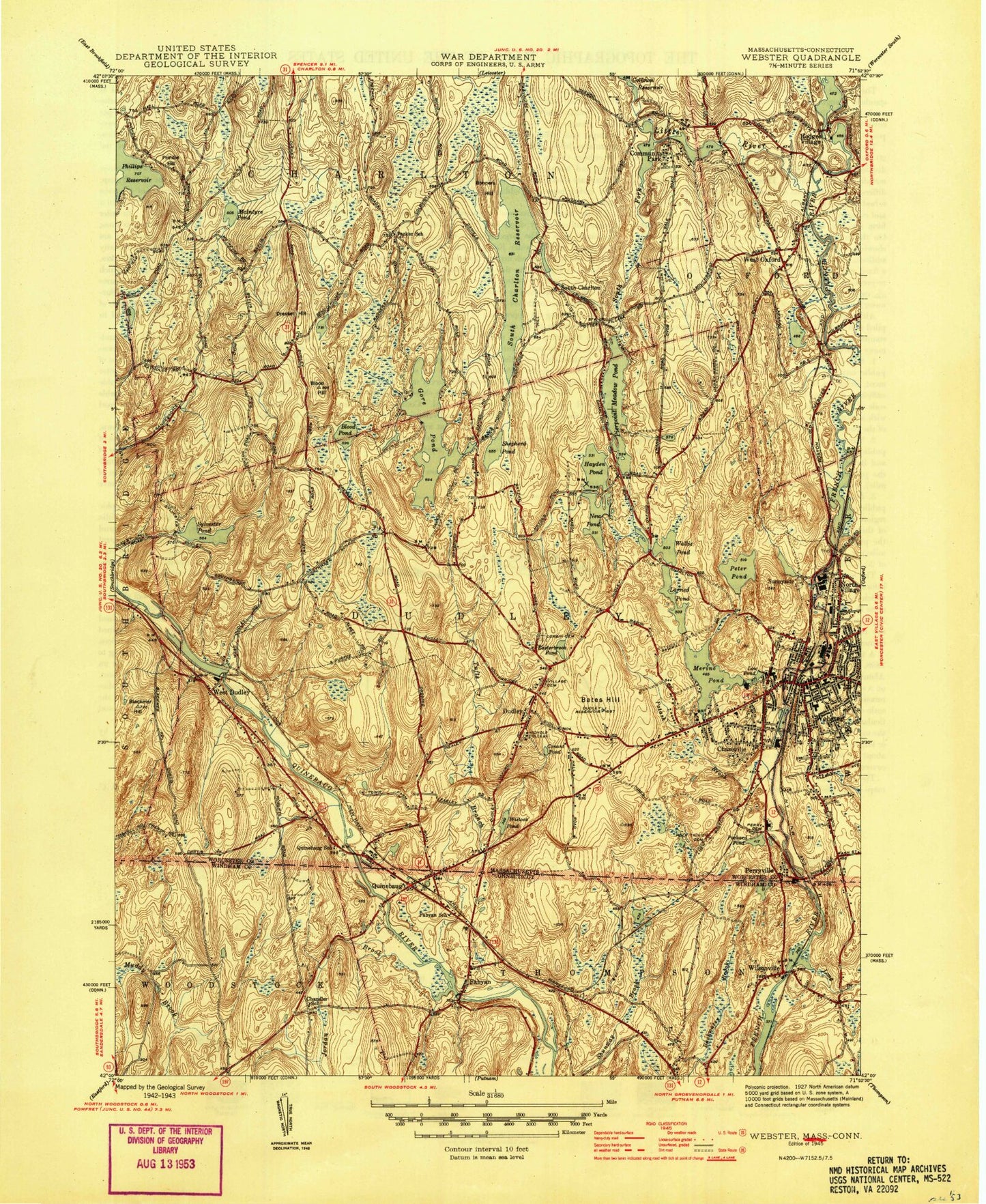
Classic USGS Webster Massachusetts 7.5'x7.5' Topo Map
Couldn't load pickup availability
Historical USGS topographic quad map of Webster in the states of Massachusetts, Connecticut. Typical map scale is 1:24,000, but may vary for certain years, if available. Print size: 24" x 27"
This quadrangle is in the following counties: Windham, Worcester.
The map contains contour lines, roads, rivers, towns, and lakes. Printed on high-quality waterproof paper with UV fade-resistant inks, and shipped rolled.
Contains the following named places: Low Pond, Nichols College, Saint Louis School, Village Cemetery, Corbin Cemetery, Northwest Cemetery, Blackmer Cemetery, Dudley Elementary School, Mason Road School, Holy Trinity Cemetery, Dudley Junior High School, Bartlett Junior-Senior High School, Dresser Cemetery, Dudley Park N Shop, Dudley Plaza, Perryville Pond Dam, French River Reservoir, Carpenter Road Pond, Carpenter Road Dam, Stocking Mill Dam, Wielock Pond Dam, Lower Merino Pond Dam, Merino Pond Dam, Quinebaug River Pond Dam, South Village Pond Dam, French River Reservoir, Larner Pond, Larner Pond Dam, Peter Pond Dam, French River Reservoir, North Webster Village Pond Dam, Wallis Pond Dam, New Pond Dam, Gore Pond Dam, Old Shepherd Pond, Old Shepherd Pond Dam, Granite Reservoir Dam, Gordon Dam, Buffumville Dam, Hodges Village Pond, Hodges Village Dam, Buffumville (historical), Merino Village (historical), Tufts Village (historical), Bates Hill, Blackmer Hill, Blood Hill, Blood Pond, Bonners Hill, Buffum Pond, Chaseville, Conant Pond, Dresser Hill, Dudley, Dudley Reservoir, Easterbrook Pond, Baker Pond, South Charlton Reservoir, Hayden Pond, Hodges Village, Little River, McIntyre Pond, Merino Pond, New Pond, North Village, Packard Pond, Perryville, Peter Pond, Pierpoint Meadow Pond, Potash Brook, Prindle Hill, Prindle Lake, Shepherd Pond, South Charlton, Sunnyside, Sylvestri Pond, Wallis Pond, Webster, West Oxford, West Dudley, Wielock Pond, Mill Brook, Pumpkin Hill, Buffumville, Fennerville, Merino Village, Buffumville Lake, Community Park (historical), Town of Dudley, Dresser Hill Airport, South Fork Little River, WESO-AM (Southbridge), WNRC-FM (Dudley), WQVR-FM (Southbridge), Anthony J Sitkowski School, Augutleback Pond, Bible Fellowship Church, Cardinal Heights, Chester C Corbin Public Library, Christ Federated United Church, Church of Reconciliation, Conant Library, District Five Schoolhouse (historical), Dudley Charlton Regional School, Dudley Fire Department, Dudley Plaza Shopping Center, Dudley Post Office, Dudley Town Hall, Emanuel Lutheran Church, First Baptist Church, First Congregational Church, Grand View Estates, Main Street Historic District, Nichols Golf Course, Saint Anne Church, Saint Louis Church, Shepherd Hill Regional High School, Webster Plaza Shopping Center, Webster Post Office, Webster Shopping Plaza Shopping Center, Central Massachusetts SPED Collaborative School, Southern Worcester County Educational Collaborative School, Webster Fire Department Station 2, Dudley Police Department, Fabyan, Jordan Brook, Langers Pond, Long Branch Brook, Perry Pond, Quinebaug, Tufts Branch, Whitkowski Ponds, Wilsonville, Wilsonville Heliport, Langers Pond Dam, Abundant Life United Church, Chancery Hill, Draper Hills, Fabyan Post Office, Forrest Hill, Meadowside Campground, Quinebaug Post Office, Saint Stephens Church, Wilsonville Cemetery, Quinebaug Census Designated Place, Quinebaug Volunteer Fire Department, Low Pond, Nichols College, Saint Louis School, Village Cemetery, Corbin Cemetery, Northwest Cemetery, Blackmer Cemetery, Dudley Elementary School, Mason Road School, Holy Trinity Cemetery, Dudley Junior High School, Bartlett Junior-Senior High School, Dresser Cemetery, Dudley Park N Shop, Dudley Plaza, Perryville Pond Dam, French River Reservoir, Carpenter Road Pond, Carpenter Road Dam, Stocking Mill Dam, Wielock Pond Dam, Lower Merino Pond Dam, Merino Pond Dam, Quinebaug River Pond Dam, South Village Pond Dam, French River Reservoir, Larner Pond, Larner Pond Dam, Peter Pond Dam, French River Reservoir, North Webster Village Pond Dam, Wallis Pond Dam, New Pond Dam, Gore Pond Dam, Old Shepherd Pond, Old Shepherd Pond Dam, Granite Reservoir Dam, Gordon Dam, Buffumville Dam, Hodges Village Pond, Hodges Village Dam, Buffumville (historical), Merino Village (historical), Tufts Village (historical), Bates Hill, Blackmer Hill, Blood Hill, Blood Pond, Bonners Hill, Buffum Pond, Chaseville, Conant Pond, Dresser Hill, Dudley, Dudley Reservoir, Easterbrook Pond, Baker Pond, South Charlton Reservoir, Hayden Pond, Hodges Village, Little River, McIntyre Pond, Merino Pond, New Pond, North Village, Packard Pond, Perryville, Peter Pond, Pierpoint Meadow Pond, Potash Brook, Prindle Hill, Prindle Lake, Shepherd Pond, South Charlton, Sunnyside, Sylvestri Pond, Wallis Pond, Webster, West Oxford, West Dudley, Wielock Pond, Mill Brook, Pumpkin Hill, Buffumville, Fennerville, Merino Village, Buffumville Lake, Community Park (historical), Town of Dudley, Dresser Hill Airport