MyTopo
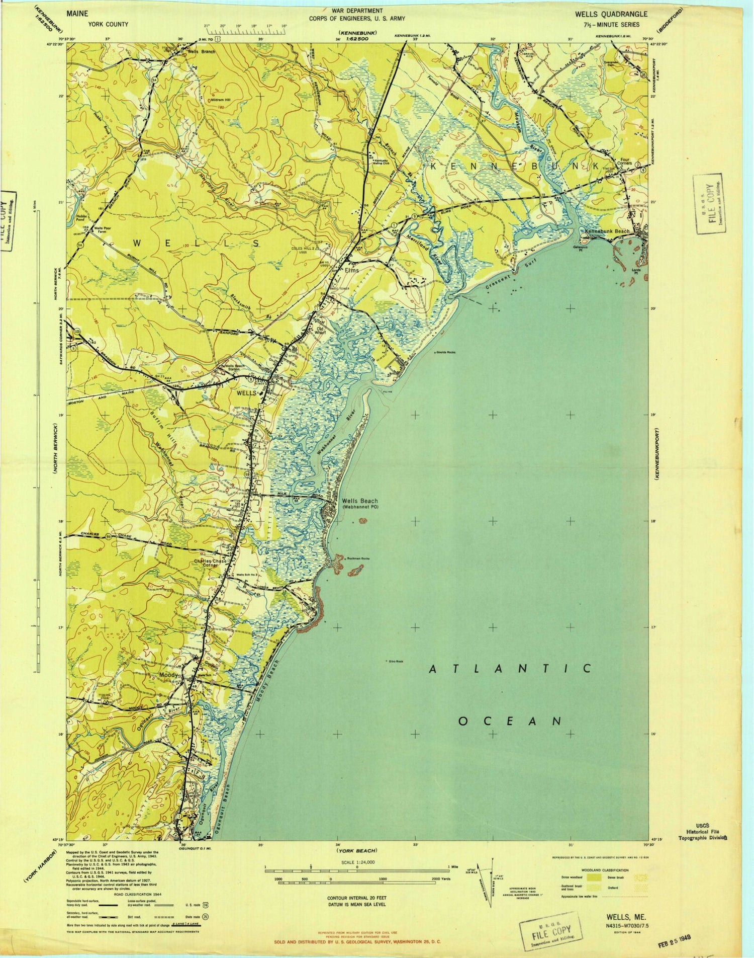
Classic USGS Wells Maine 7.5'x7.5' Topo Map
Couldn't load pickup availability
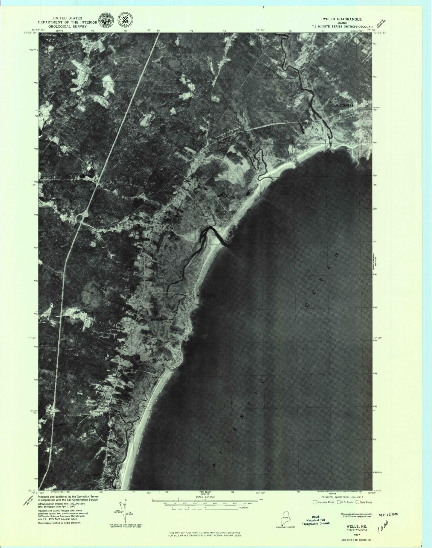
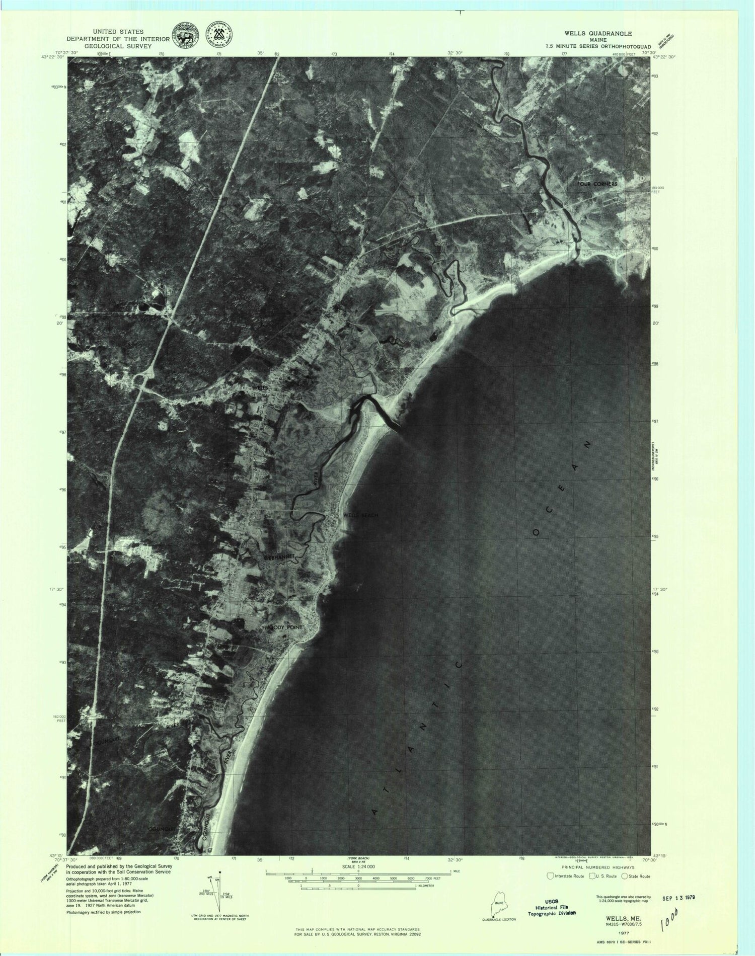
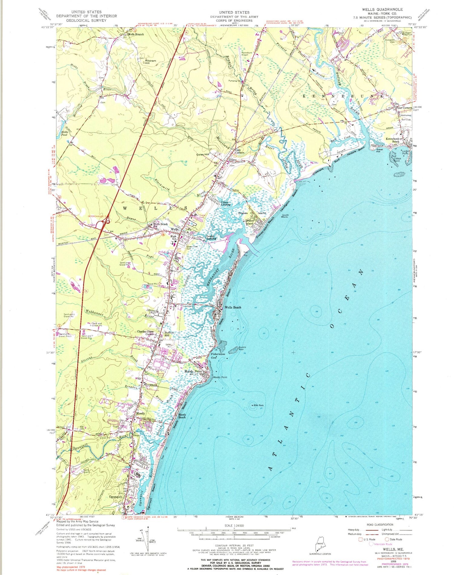
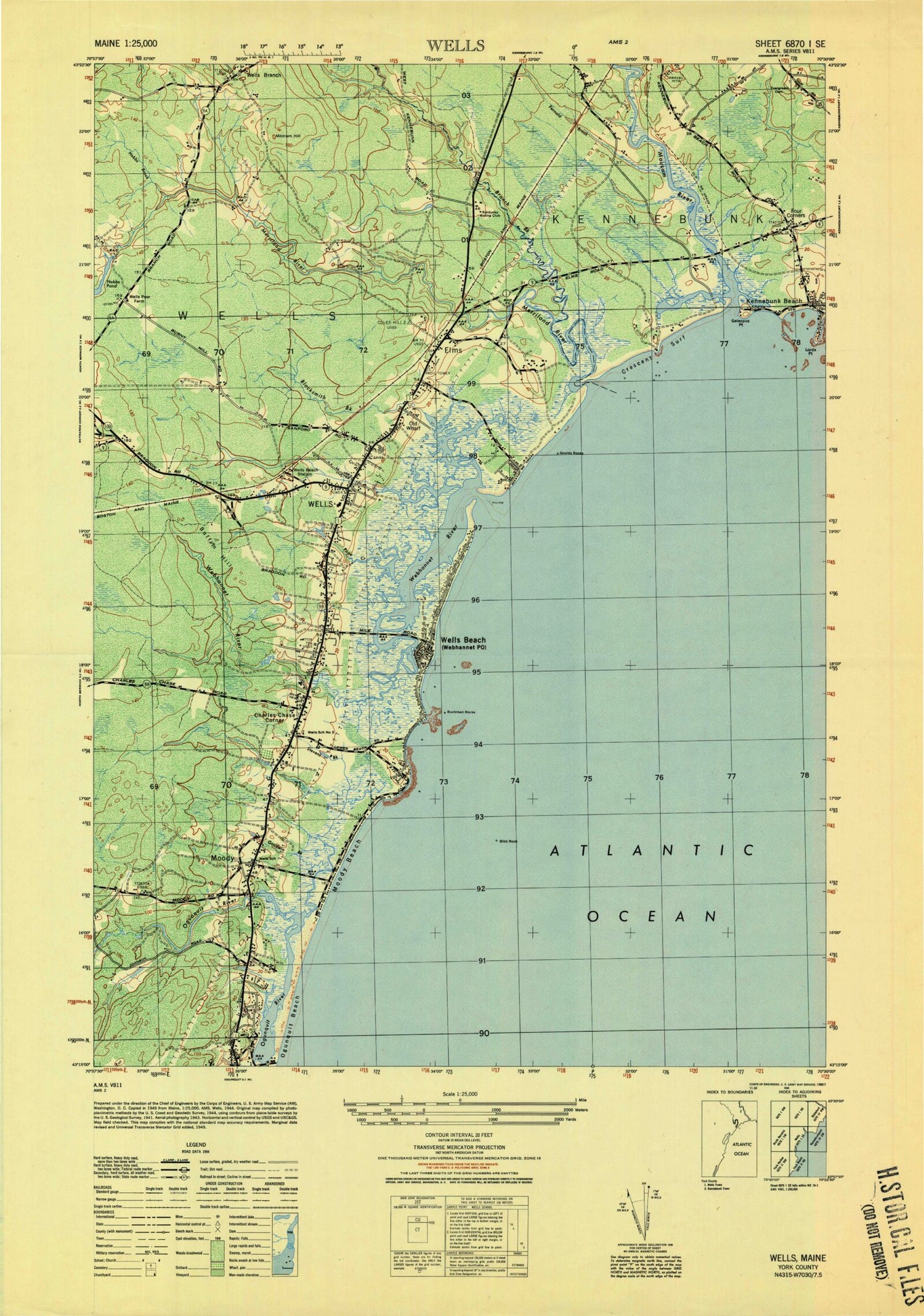
Historical USGS topographic quad map of Wells in the state of Maine. Typical map scale is 1:24,000, but may vary for certain years, if available. Print size: 24" x 27"
This quadrangle is in the following counties: York.
The map contains contour lines, roads, rivers, towns, and lakes. Printed on high-quality waterproof paper with UV fade-resistant inks, and shipped rolled.
Contains the following named places: Back Creek, Bibb Rock, Blacksmith Brook, Bragdon Brook, Branch Brook, Bucklin Rock, Buffum Hill, Charles Chase Corner, Coles Hill, Cozy Corners, Crescent Surf, Depot Brook, Drakes Island, Drakes Island, Drakes Island Beach, Elms, Evergreen Cemetery, Fernald Brook, Fishermans Cove, Four Corners, Goulds Rocks, Great Hill, Hobbs Brook, Hobbs Pond, Kennebunk Beach, Laudholm Beach, Libbys Point, Little River, Lords Point, Merriland River, Mildram Hill, Moody, Moody Beach, Moody Beach, Moody Point, Moody Point, Mousam River, Ocean View Cemetery, Ogunquit Beach, Parsons Beach, Pope Creek, Stevens Brook, Webhannet River, Wells, Wells Beach, Wells Beach, Wells Beach Station, Wells Branch, Lower Landing, Upper Landing, Kennebunk Airport (historical), Wells Harbor, Webhannet Golf Club, Town of Wells, Hobbs Pond Dam, Merriland River Reservoir, Advent Christian Church, Beach Acres Campground, Congregational Church of Wells, First Congregational Church, Footbridge Beach, Gregoires Campground, Kennebunk Christian Academy, Kennebunk Health and Homecare Services, Laudholm Farm (historical), Messiah Christian Church, One Casino Square Shopping Center, Pinderosa Campground, Saint Davids Episcopal Church, The Wells National Estuarine Research Reserve, The Wells Reserve Visitors Center, Webhannet River Marsh, Wells Auto Museum, Wells Corner Shopping Center, Wells Elementary School, Wells High School, Wells Information Center, Wells Junior High School, Wells Post Office, Wells Public Library, Wells Shopping Plaza Shopping Center, Wells Fire Department Main Station, Wells Fire Department Branch Station, Wells Emergency Medical Services, Wells Police Department, Unnamed Cemetery, Wells Branch Baptist Church Cemetery, Riverside Cemetery, York County Community College, Cocoons Day School, Dorothy Fish Coastal Resource Library Wells Reserve, York County Community College Library, Back Creek, Bibb Rock, Blacksmith Brook, Bragdon Brook, Branch Brook, Bucklin Rock, Buffum Hill, Charles Chase Corner, Coles Hill, Cozy Corners, Crescent Surf, Depot Brook, Drakes Island, Drakes Island, Drakes Island Beach, Elms, Evergreen Cemetery, Fernald Brook, Fishermans Cove, Four Corners, Goulds Rocks, Great Hill, Hobbs Brook, Hobbs Pond, Kennebunk Beach, Laudholm Beach, Libbys Point, Little River, Lords Point, Merriland River, Mildram Hill, Moody, Moody Beach, Moody Beach, Moody Point, Moody Point, Mousam River, Ocean View Cemetery, Ogunquit Beach, Parsons Beach, Pope Creek, Stevens Brook, Webhannet River, Wells, Wells Beach, Wells Beach, Wells Beach Station, Wells Branch, Lower Landing, Upper Landing, Kennebunk Airport (historical), Wells Harbor, Webhannet Golf Club, Town of Wells, Hobbs Pond Dam, Merriland River Reservoir, Advent Christian Church, Beach Acres Campground, Congregational Church of Wells, First Congregational Church, Footbridge Beach, Gregoires Campground, Kennebunk Christian Academy, Kennebunk Health and Homecare Services, Laudholm Farm (historical), Messiah Christian Church, One Casino Square Shopping Center, Pinderosa Campground, Saint Davids Episcopal Church, The Wells National Estuarine Research Reserve, The Wells Reserve Visitors Center, Webhannet River Marsh, Wells Auto Museum, Wells Corner Shopping Center, Wells Elementary School, Wells High School, Wells Information Center, Wells Junior High School, Wells Post Office, Wells Public Library, Wells Shopping Plaza Shopping Center, Wells Fire Department Main Station, Wells Fire Department Branch Station, Wells Emergency Medical Services, Wells Police Department, Unnamed Cemetery, Wells Branch Baptist Church Cemetery, Riverside Cemetery, York County Community College, Cocoons Day School, Dorothy Fish Coastal Resource Library Wells Reserve, York County Community College Library, Back Creek, Bibb Rock, Blacksmith Brook, Bragdon Brook, Branch Brook, Bucklin Rock, Buffum Hill, Charles Chase Corner, Coles Hill, Cozy Corners, Crescent Surf, Depot Brook, Drakes Island, Drakes Island, Drakes Island Beach, Elms, Evergreen Cemetery, Fernald Brook, Fishermans Cove, Four Corners, Goulds Rocks, Great Hill, Hobbs Brook, Hobbs Pond, Kennebunk Beach, Laudholm Beach, Libbys Point, Little River, Lords Point, Merriland River, Mildram Hill, Moody, Moody Beach, Moody Beach, Moody Point, Moody Point, Mousam River, Ocean View Cemetery, Ogunquit Beach, Parsons Beach, Pope Creek, Stevens Brook, Webhannet River, Wells, Wells Beach, Wells Beach, Wells Beach Station, Wells Branch, Lower Landing, Upper Landing, Kennebunk Airport (historical), Wells Harbor