
MyTopo
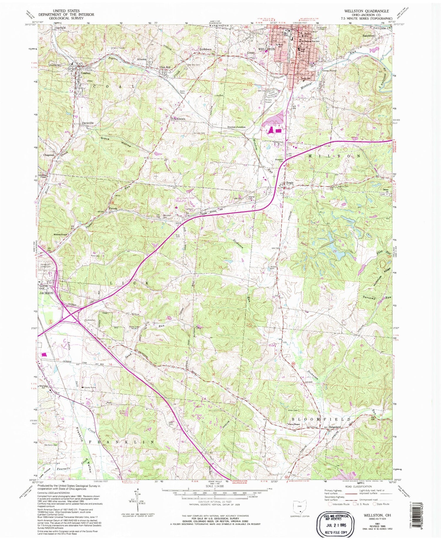
Classic USGS Wellston Ohio 7.5'x7.5' Topo Map
Couldn't load pickup availability
Historical USGS topographic quad map of Wellston in the state of Ohio. Typical map scale is 1:24,000, but may vary for certain years, if available. Print size: 24" x 27"
This quadrangle is in the following counties: Jackson.
The map contains contour lines, roads, rivers, towns, and lakes. Printed on high-quality waterproof paper with UV fade-resistant inks, and shipped rolled.
Contains the following named places: Baptist Cemetery, Campbell Cemetery, Coalton Cemetery, Columbia Chapel, Eisnaugle Hollow, Glen Roy Cemetery, Grace Hollow, Hale Cemetery, Hillside Chapel, Keenan Cemetery, Licks Cemetery, McGee Cemetery, Meadow Run, Petrea, Rice Cemetery, Ridgeland, Ryan Cemetery, Saints Peter and Paul School, Sand Run, Sullivan Cemetery, Union Cemetery, Union Chapel, Wells School, Woodson Cemetery, Comet, Davisville, Garfield, Tom Corwin, Wellston, Coalton Elementary School, Wellston High School, Eliza School (historical), Locust Grove School (historical), Latrobe School (historical), Latrobe (historical), Hoganville School (historical), Fairview School (historical), Victory School (historical), Poore School (historical), Walnut Grove School (historical), Poplar Grove School (historical), Maple Grove (historical), Morgantown (historical), Englishville, Columbia School (historical), Kessinger School (historical), Kansas School (historical), Jackson County Home, Bunn School (historical), Coalton, Ratchford, Fairmount Cemetery, Chapman, Fourmile Creek, Roads, Altoona, Glen Roy, Ironton Junction, Goldsboro, Salem Church, Bundy Elementary School, First Baptist Church, Hope United Methodist Church, Nazarene Church, Salem Cemetery, Trinity United Methodist Church, Wellston Church of God, Wellston Presbyterian Church, Jackson County, Franklin Valley, Lake Hollow, Banquet Foods Reservoir Dam, Banquet Foods Reservoir, Ohnoname 20 Dam, Ohnoname 20 Reservoir, Ohnoname 21 Dam, Ohnoname 21 Reservoir, Ohnoname 22 Dam, Ohnoname 22 Reservoir, Di-Or Pond Dam, Di-Or Pond, Sickles Pond Dam, Sickles Pond, Old Bunn Cemetery, WLMJ Radio Tower, Jackson County Fairground, South School, Central School, Winters Airport (historical), Wellston Post Office, Baisden Airport, WLMJ-AM (Jackson), WKOV-AM (Wellston), WCJO-FM (Jackson), WKOV-FM (Wellston), Township of Coal, Township of Lick, City of Wellston, Apostolic Tabernacle of Praise, Cornerstone Word of Life Church, Saints Peter and Paul Catholic Church, Chapman Post Office (historical), Glenroy Post Office (historical), Coalton Post Office (historical), Petrea Post Office (historical), Ratchford Post Office (historical), Village of Coalton, Coalton Volunteer Fire Department, Southeast Ohio Emergency Medical Services Station 8, Southeast Ohio Emergency Medical Services Station 9 Jackson, Wellston Landfill, Wellston Police Department, Coalton Post Office


