MyTopo
Classic USGS West Burlington Iowa 7.5'x7.5' Topo Map
Couldn't load pickup availability
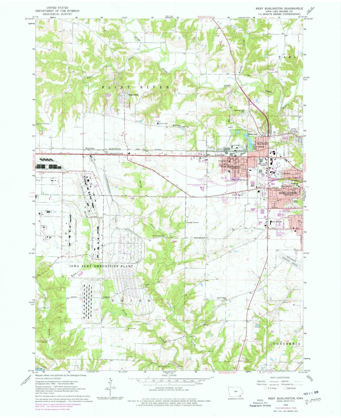
Historical USGS topographic quad map of West Burlington in the state of Iowa. Typical map scale is 1:24,000, but may vary for certain years, if available. Print size: 24" x 27"
This quadrangle is in the following counties: Des Moines, Lee.
The map contains contour lines, roads, rivers, towns, and lakes. Printed on high-quality waterproof paper with UV fade-resistant inks, and shipped rolled.
Contains the following named places: Beaverdale, Brush College School, Buena Vista School, Burk Chapel, Burlington Christian School, Greenwood Cemetery, Honey Creek, Hope Haven School, West Burlington Middle School, Knotty Creek, Leuins Point Cemetery, Little Flint Creek, Izaak Walton Lake, Burlington Memorial Park Cemetery, Burlington Notre Dame Junior / Senior High School, Rock Spring Cemetery, Saint Mary School, Shiloh Cemetery, Southeastern Community College West Burlington Campus, Spring Creek Cemetery, Burlington Alternative High School, West Burlington, West Lake, KGRS-FM (Burlington), Clark Field House, Tri-State Fairgrounds, Burlington Jewish Cemetery, KCPS-AM (Burlington), KBUR-AM (Burlington), KJMH-TV (Burlington), Township of Flint River, Township of Union, Des Moines County Fairgrounds, Kevin J Gahn Wildlife Refuge, Van Dyke Post Office (historical), West Burlington, West Burlington Fire Department, West Burlington Police Department, West Burlington Post Office, Echo Valley Mobile Home Park, Westland Mall, Heartland Foot Care Center, Great River Medical Center, River Cities Opthalmology Center, Internal Medicine Center Incorporated, Great River Womens Health Center, Gastroenterology Clinic, Healthwest Clinic, Burlington Pediatrics Association Center, Burlington Obstetrics and Gynecology Center, Burlington Ear Nose and Throat Clinic, West Burlington United Methodist Church, Jehovahs Witnesses Church, West Burlington Church of God, Christian Church West Burliington, Wings of Praise Church, Saint Paul United Church of Christ, Saint Mary's Church, Peace Lutheran Church, West Burlington Arnold Junior / Senior High School, West Burlington Elementary School, Congers Mobile Home Park, Flint Bottom Raceway, Starr's Cave Nature Center, Messiah Lutheran Church, West Avenue Baptist Church, Calvary Baptist Church, First Assembly of God Church, Flint Hills Church of the Nazarene, Our Savior Lutheran Church, The Church of Jesus Christ of Latter Day Saints, Concordia Lutheran Church, Bible Missionary Church, Peace Mennonite Church, Burlington Baptist Church, Riverside Baptist Church, Jehovah's Witness Woodland Congregation, Church of Christ, Faith Lutheran Church, Sunnyside Avenue Baptist Church, Faith Academy, Burlington High School, Sundown Golf Course, Cottonwood Park, Burlington Dermatology Center, Miller Chiropractic Clinic, American Eyecare Center, Heartland Foot and Ankle Clinic, River Valley Family Practice Center, Sterling House, Great River Eye Care, Community Field, VFW Picnic Park, West Burlington Community Park, Longmeadow Park, Luers Park, Burlington Regional Recreational Complex, Hunt Woods Park, Wykerts Cemetery, Old County Home Cemetery, Porter Cemetery, Swede Cemetery, Carter Burial Plot, Mormon Cemetery, Elliott Cemetery, Schnupper Farm Cemetery, Saint Marys Cemetery, Johnson Cemetery, Flint River Township Cemetery, Pathway of the Pioneers Historical Marker, Burlington Chiropractic Center, City of West Burlington, Iowa Army Ammunition Plant, Medforce Aeromedical Transport Base 2, Superior Ambulance Service, Beaverdale Census Designated Place, Ancam Antique Airfield, Steingreaber Cemetery, Burlington Cemetery (historical), Diewold Airport, West Burlington Junior / Senior High School, Burlington Notre Dame Catholic Elementary School, Aldo Leopold Intermediate School, Oak Hills Census Designated Place, Oak Hills