MyTopo
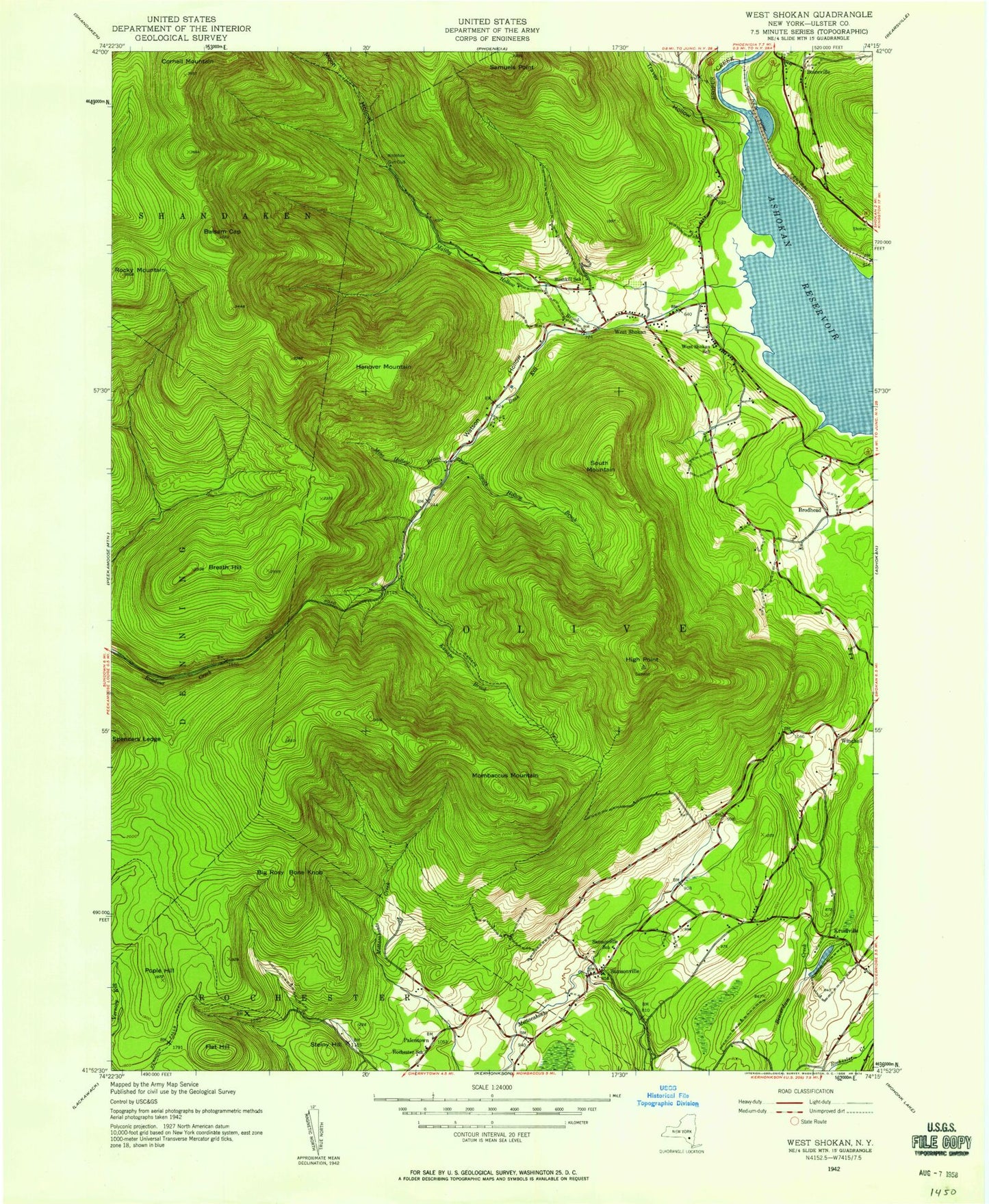
Classic USGS West Shokan New York 7.5'x7.5' Topo Map
Couldn't load pickup availability
Historical USGS topographic quad map of West Shokan in the state of New York. Typical map scale is 1:24,000, but may vary for certain years, if available. Print size: 24" x 27"
This quadrangle is in the following counties: Ulster.
The map contains contour lines, roads, rivers, towns, and lakes. Printed on high-quality waterproof paper with UV fade-resistant inks, and shipped rolled.
Contains the following named places: Balsam Cap, Beaver Lake, Big Rosy Bone Knob, Breath Hill, Brodhead, Bush Kill, Dry Brook, Flat Hill, Friday Mountain, Hanover Mountain, High Point, Kanape Brook, Kanape Jeep Trail, Little Rocky, Maltby Hollow Brook, Mine Hollow, Mombaccus Mountain, Palentown Cemetery, Picket Brook, Pople Hill, Rocky Mountain, Samsonville, Samuels Point, South Hollow Brook, South Mountain, Spencers Ledge, Steiny Hill, Traver Hollow, Vernooy Falls Trail, Watson Hollow, West Shokan, Wittenberg Brook, Palentown, Winchell, Ulster County, Town of Olive, Father Divine Lodge (historical), Moonhaw Gun Club, Brodhead School (historical), Bushkill School (historical), Rochester School (historical), Samsonville School (historical), West Shokan School (historical), Winchell School (historical), Olive Free Library, Olive Volunteer Fire Department 1 Samsonville Company 4, Olive Volunteer Fire Department 1 West Shokan Company 3, West Shokan Post Office, Balsam Cap, Beaver Lake, Big Rosy Bone Knob, Breath Hill, Brodhead, Bush Kill, Dry Brook, Flat Hill, Friday Mountain, Hanover Mountain, High Point, Kanape Brook, Kanape Jeep Trail, Little Rocky, Maltby Hollow Brook, Mine Hollow, Mombaccus Mountain, Palentown Cemetery, Picket Brook, Pople Hill, Rocky Mountain, Samsonville, Samuels Point, South Hollow Brook, South Mountain, Spencers Ledge, Steiny Hill, Traver Hollow, Vernooy Falls Trail, Watson Hollow, West Shokan, Wittenberg Brook, Palentown, Winchell, Ulster County, Town of Olive, Father Divine Lodge (historical), Moonhaw Gun Club, Brodhead School (historical), Bushkill School (historical), Rochester School (historical), Samsonville School (historical), West Shokan School (historical), Winchell School (historical), Olive Free Library, Olive Volunteer Fire Department 1 Samsonville Company 4, Olive Volunteer Fire Department 1 West Shokan Company 3, West Shokan Post Office, Balsam Cap, Beaver Lake, Big Rosy Bone Knob, Breath Hill, Brodhead, Bush Kill, Dry Brook, Flat Hill, Friday Mountain, Hanover Mountain, High Point, Kanape Brook, Kanape Jeep Trail, Little Rocky, Maltby Hollow Brook, Mine Hollow, Mombaccus Mountain, Palentown Cemetery, Picket Brook, Pople Hill, Rocky Mountain, Samsonville, Samuels Point, South Hollow Brook, South Mountain, Spencers Ledge, Steiny Hill, Traver Hollow, Vernooy Falls Trail, Watson Hollow, West Shokan, Wittenberg Brook, Palentown, Winchell, Ulster County, Town of Olive, Father Divine Lodge (historical), Moonhaw Gun Club, Brodhead School (historical), Bushkill School (historical), Rochester School (historical), Samsonville School (historical), West Shokan School (historical), Winchell School (historical), Olive Free Library, Olive Volunteer Fire Department 1 Samsonville Company 4, Olive Volunteer Fire Department 1 West Shokan Company 3, West Shokan Post Office