MyTopo
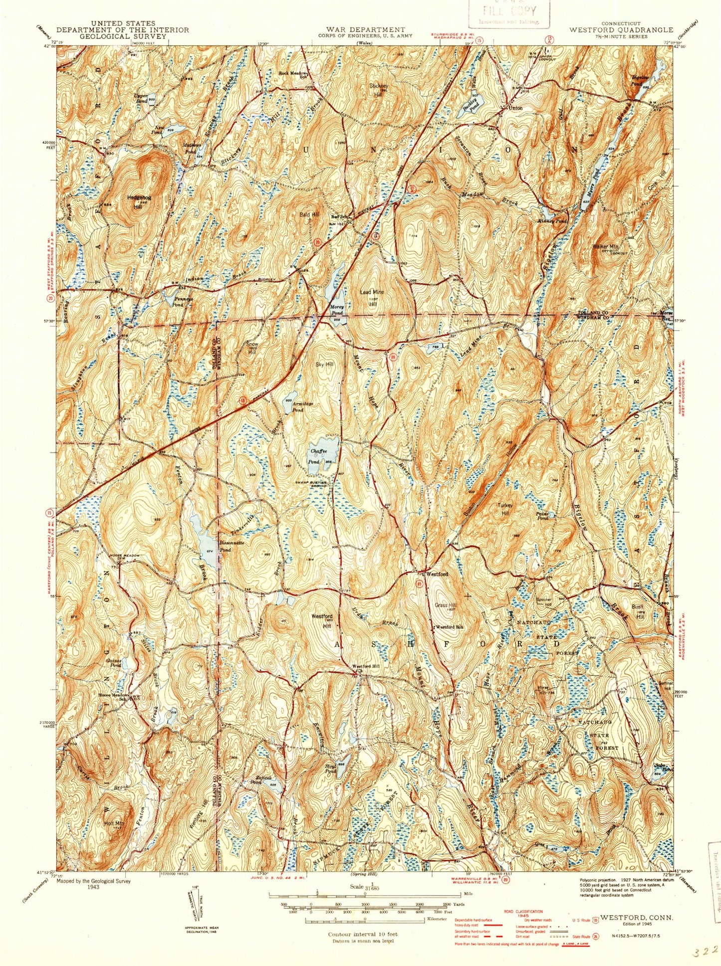
Classic USGS Westford Connecticut 7.5'x7.5' Topo Map
Couldn't load pickup availability
Historical USGS topographic quad map of Westford in the state of Connecticut. Typical map scale is 1:24,000, but may vary for certain years, if available. Print size: 24" x 27"
This quadrangle is in the following counties: Tolland, Windham.
The map contains contour lines, roads, rivers, towns, and lakes. Printed on high-quality waterproof paper with UV fade-resistant inks, and shipped rolled.
Contains the following named places: Armitage Pond, Ashford Lake, Ashford Elementary School, Bald Hill, Basset Brook, Bigelow Pond, Bigelow State Park, Bissonnette Pond, Boston Hollow, Buckley Pond, Buell Hill, Bush Meadow Brook, Cedar Swamp Brook, Lake Chaffee, Coye Hill, Curtis Brook, Drobney Pond, East Branch Mount Hope River, Gaines Pond, Grass Hill, Gulf Brook, Hammond Brook, Hedgehog Hill, Holt Mountain, Horse Hill, Kidder Brook, Kinney Pond, Lead Mine Brook, Lead Mine Hill, Mathews Pond, Moose Meadow Cemetery, Moose Meadow School, Morey Pond, Myers Pond, Natchaug State Forest, New Pond, North Chism Brook, Paine Pond, Pinneys Pond, Rock Meadow School, Sabo Pond, Scranton Brook, Sky Hill, Snow Hill, South Chism Brook, Spooner Hill, Stickney Hill, Stickney Hill Brook, Stiles Brook, Stowell Pond, Swamp Cemetery, Taylor Pond, Turkey Hill, Union, Union School, Upper Pond, Urda Brook, Walker Mountain, Wenberg Hill, Westford, Westford Hill, Westford Hill Church, Westford Village Cemetery, Zaicek Pond, Union Lookout Tower, Westford Airstrip, Town of Ashford, Town of Union, Stafford Springs Reservoir Number 2 Dam, Stafford Springs Reservoir Number 2, Bigelow Pond Dam, Ashford Lake Dam, Morey Pond Dam, Goss Brook Dam, Boy Scout Pond, Lake Chaffee Dam, Pinneys Pond Dam Number 1, Bissonnette Pond Dam, New Pond Dam, Boston Hollow Road Brook, Brialee Campground, Buck Pond, Goss Pond, June Norcross Webster Scout Reservation, Sharpe Hill, Tinkerville Brook Preserve, Westford Congregational Church, Westford Hill Cemetery, Union Volunteer Fire Department, Ashford Volunteer Fire Department Station 220, Lake Chaffee Census Designated Place, Lake Chaffee, Armitage Pond, Ashford Lake, Ashford Elementary School, Bald Hill, Basset Brook, Bigelow Pond, Bigelow State Park, Bissonnette Pond, Boston Hollow, Buckley Pond, Buell Hill, Bush Meadow Brook, Cedar Swamp Brook, Lake Chaffee, Coye Hill, Curtis Brook, Drobney Pond, East Branch Mount Hope River, Gaines Pond, Grass Hill, Gulf Brook, Hammond Brook, Hedgehog Hill, Holt Mountain, Horse Hill, Kidder Brook, Kinney Pond, Lead Mine Brook, Lead Mine Hill, Mathews Pond, Moose Meadow Cemetery, Moose Meadow School, Morey Pond, Myers Pond, Natchaug State Forest, New Pond, North Chism Brook, Paine Pond, Pinneys Pond, Rock Meadow School, Sabo Pond, Scranton Brook, Sky Hill, Snow Hill, South Chism Brook, Spooner Hill, Stickney Hill, Stickney Hill Brook, Stiles Brook, Stowell Pond, Swamp Cemetery, Taylor Pond, Turkey Hill, Union, Union School, Upper Pond, Urda Brook, Walker Mountain, Wenberg Hill, Westford, Westford Hill, Westford Hill Church, Westford Village Cemetery, Zaicek Pond, Union Lookout Tower, Westford Airstrip, Town of Ashford, Town of Union, Stafford Springs Reservoir Number 2 Dam, Stafford Springs Reservoir Number 2, Bigelow Pond Dam, Ashford Lake Dam, Morey Pond Dam, Goss Brook Dam, Boy Scout Pond, Lake Chaffee Dam, Pinneys Pond Dam Number 1, Bissonnette Pond Dam, New Pond Dam, Boston Hollow Road Brook, Brialee Campground, Buck Pond, Goss Pond, June Norcross Webster Scout Reservation, Sharpe Hill, Tinkerville Brook Preserve, Westford Congregational Church, Westford Hill Cemetery, Union Volunteer Fire Department, Ashford Volunteer Fire Department Station 220, Lake Chaffee Census Designated Place, Lake Chaffee