
MyTopo
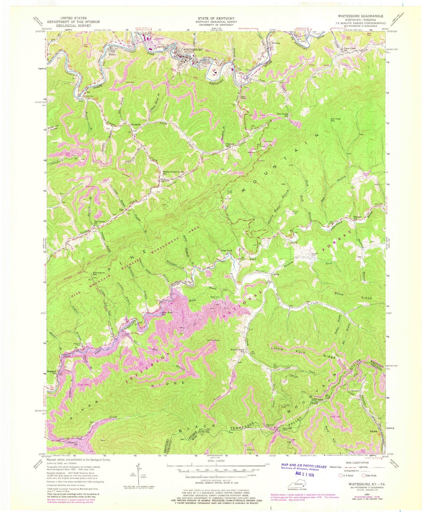
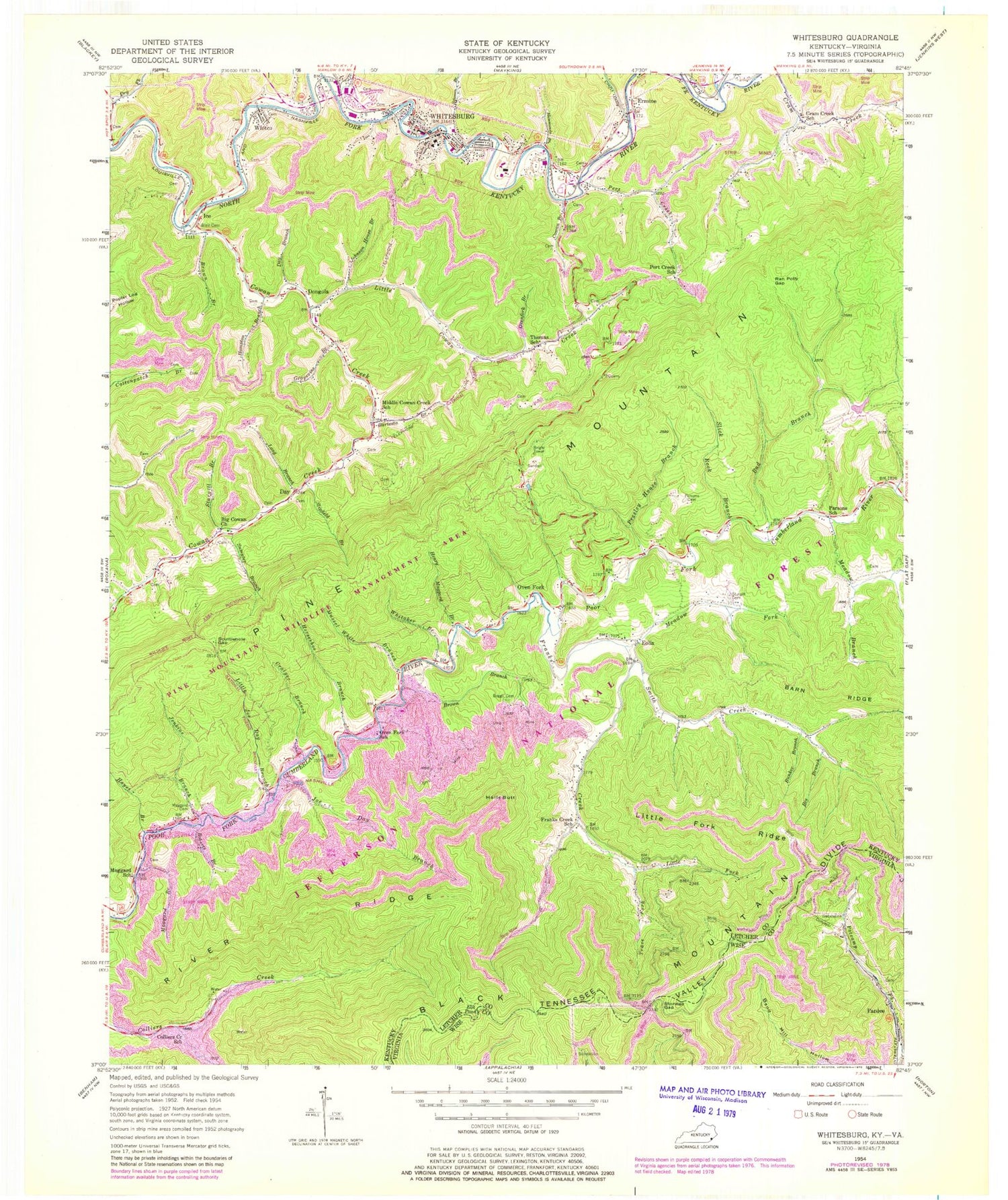
Classic USGS Whitesburg Kentucky 7.5'x7.5' Topo Map
Couldn't load pickup availability
Historical USGS topographic quad map of Whitesburg in the states of Kentucky, Virginia. Typical map scale is 1:24,000, but may vary for certain years, if available. Print size: 24" x 27"
This quadrangle is in the following counties: Letcher, Wise.
The map contains contour lines, roads, rivers, towns, and lakes. Printed on high-quality waterproof paper with UV fade-resistant inks, and shipped rolled.
Contains the following named places: South Fork Collier Creek, Bad Branch, Barn Ridge, Bartesta Branch, Bee Branch, Big Cowan Church, Blair Cemetery, Boggs Cemetery, Brown Branch, Brown Branch, Bunker Branch, Colliers Creek School, Cowan Branch, Cowan Creek, Crafts Colly Creek, Craiger Branch, Cram Creek School, Day Branch, Elk Pond, Ermine, Franks Creek, Franks Creek School, Grapevine Branch, Halls Butt, Hammonds Branch, Hampton Branch, Hayes Branch, Henry Maggard Branch, Horseshoe Branch, Jenkins Branch, Joe Day Branch, Johnson House Branch, Little Cowan Creek, Little Fork, Little Fork Ridge, Little Joe Day Branch, Long Branch, Maggard Branch, Maggard Cemetery, Maggard School, Meadow Branch, Meadow Fork, Middle Cowan Creek School, Mussel White Branch, Oven Fork School, Ovenfork Branch, Parsons Cemetery, Parsons School, Pert Creek, Pert Creek School, Presley House Branch, Ran Polly Gap, River Ridge, Roberts Branch, Sandlick Creek, Scuttlehole Gap, Shop Branch, Slick Rock Branch, Slipfield Branch, Smith Creek, Solomon Branch, Sturgill Branch, Sturgill Cemetery, Sumpter Branch, Thomas School, Trace Fork, Whitaker Branch, Whitco, Whitesburg, Day, Dongola, Eolia, Ice, Oven Fork, Letcher County, Appalachian Regional Hospital Heliport, Pine Mountain Aero Heliport, WXKQ-FM (Whitesburg), Eolia Division, Hensley-Pine Mountain Wildlife Management Area, Staggerweed Branch, Whitco Post Office (historical), Cenco Railroad Station (historical), High Rock, Ice Post Office (historical), Maggard Post Office (historical), Mandrake Post Office (historical), Oven Fork Post Office (historical), Pardridhe Post Office (historical), Sandlick Church, School Number Four (historical), School Number Nine (historical), School Number Two (historical), West Whitesburg (historical), Whitco Post Office (historical), Whitco Railroad Station (historical), Big Cowan (historical), Bright Tower, Colly Post Office (historical), Cowan Elementary School (historical), Crafts Colly (historical), Cram Creek Church, Day Post Office (historical), Dongola Post Office (historical), Eolia Church, Eolia Post Office, Eolia School (historical), Ermine Post Office, City of Whitesburg, Cumberland River Volunteer Fire Department, Whitesburg Fire Department, Cumberland River Volunteer Fire Department Station 2, Whitesburg Appalachian Regional Hospital, Scuttle Hole Gap Road Historical Marker, Archelous Craft Historical Marker, Francis Gary Powers Historical Marker, Whitesburg Police Department, Letcher County Sheriff's Office, Whitesburg Post Office, Stonega Gap, Pardee (historical)