MyTopo
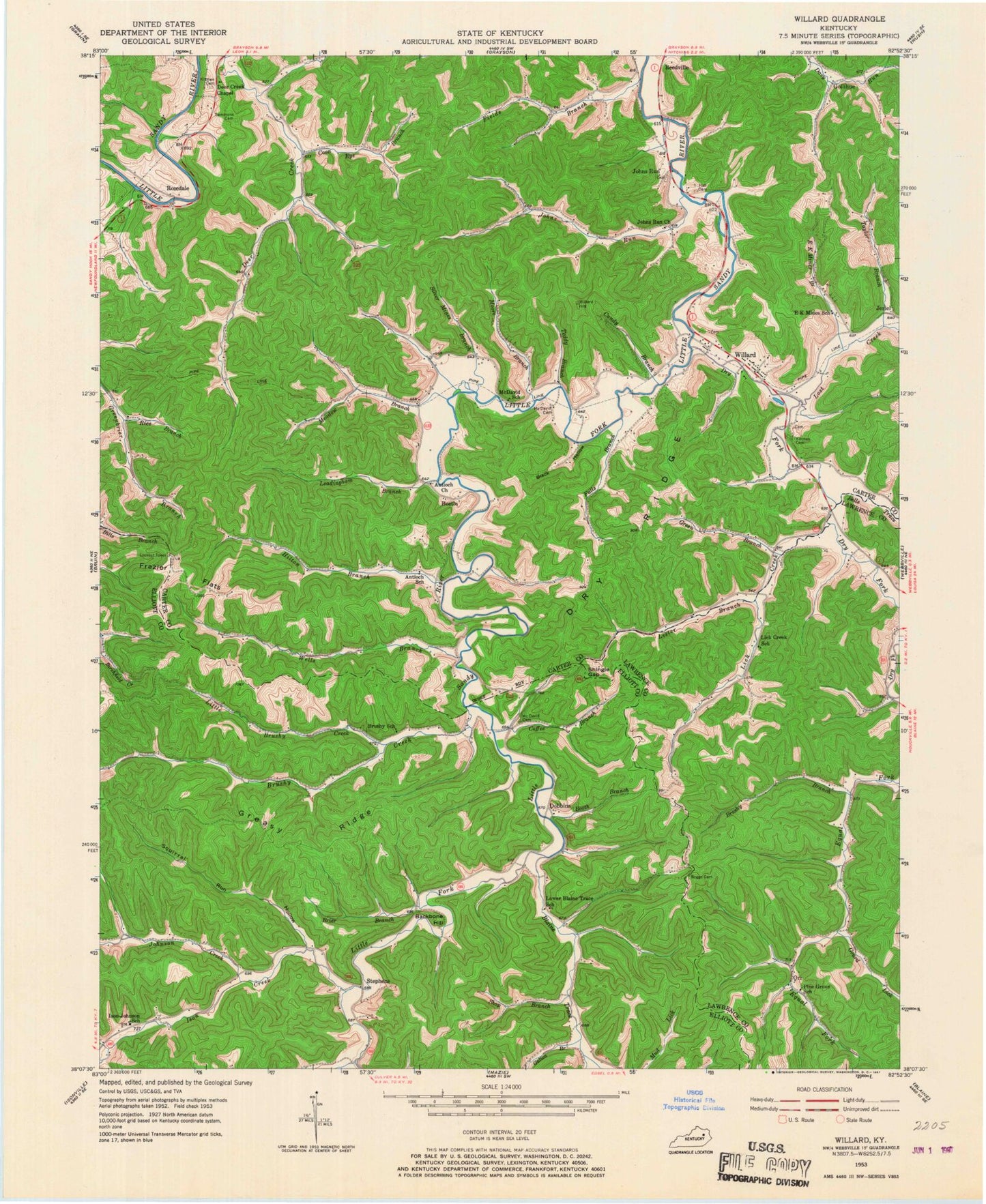
Classic USGS Willard Kentucky 7.5'x7.5' Topo Map
Couldn't load pickup availability
Historical USGS topographic quad map of Willard in the state of Kentucky. Typical map scale is 1:24,000, but may vary for certain years, if available. Print size: 24" x 27"
This quadrangle is in the following counties: Carter, Elliott, Lawrence.
The map contains contour lines, roads, rivers, towns, and lakes. Printed on high-quality waterproof paper with UV fade-resistant inks, and shipped rolled.
Contains the following named places: Backbone Hill, Bells Trace Creek, Black Hollow, Blaine Trace, Boggs Cemetery, Booth Branch, Brier Branch, Brushy Branch, Brushy Creek, Camp Webb, Candy Branch, Coffee Branch, Conway Hollow, Coon Eye Branch, Deer Creek, Dry Fork, Dry Ridge, E K Mines Branch, Lower Blaine Trace Enterprise Baptist Church, Falls Branch, Fields Branch, Frazier Flats, Galion Branch, Gourd Lick, Greasy Ridge, Green Branch, Hall Cemetery, Hamilton Creek, Hensley Cemetery, Hensley Hollow, Hilton Branch, Ison Creek, Johns Run, Johns Run Church, Johnson Creek, Kitchen Cemetery, Leadingham Branch, Lester Branch, Lick Creek, Little Brushy Creek, Little Fork Church, Lost Creek, McDavid Cemetery, Meadow Branch, Moore Branch, Mount Chapel Church, Rice Branch, Rockhouse Fork, Shingle Gap, Shop Branch, Silver Mines Branch, Squirrel Run Hollow, Taylor Branch, Teddy Branch, Wells Branch, Willard, Beetle, Dobbins, Gollihue, Jeriel, Johns Run, Orr, Stephens, Willard Division, Backbone Cemetery, McDavid Branch, Orr Post Office (historical), Sansilk Post Office (historical), Stephens Post Office (historical), Ison-Johnson School (historical), Lower Blaine Trace School (historical), Frazier Flat Lookout Tower, Lick Creek (historical), Kitchen Cemetery (historical), Sammons Cemetery, Sammons Cemetery (historical), Davys Church, McDavid Cemetery, Porter's Store (historical), Gomez (historical), Dobbins Post Office (historical), Johns Run Post Office (historical), Deer Creek Chapel, Grayson Game Refuge Area, Antioch (historical), Davy Run (historical), Jeriel Post Office (historical), McDavid Post Office (historical), Lego Post Office (historical), Little John Post Office (historical), Rosedale Post Office (historical), Beetle Post Office (historical), Reedville Post Office (historical), Gollihue Post Office (historical), Dry Fork Post Office (historical), Mountain Chapel United Baptist Church, Partlow Post Office (historical), Deer Creek Post Office (historical), Deer Creek School (historical), Antioch School (historical), McDavid School (historical), Davys School (historical), E.K. Mines School (historical), Frazier Flat Lookout Tower, Kitchen Cemetery, Brushy School (historical), Marantha Bible Church (historical), Dry Ridge School (historical), Lick Creek School (historical), Willard Post Office