MyTopo
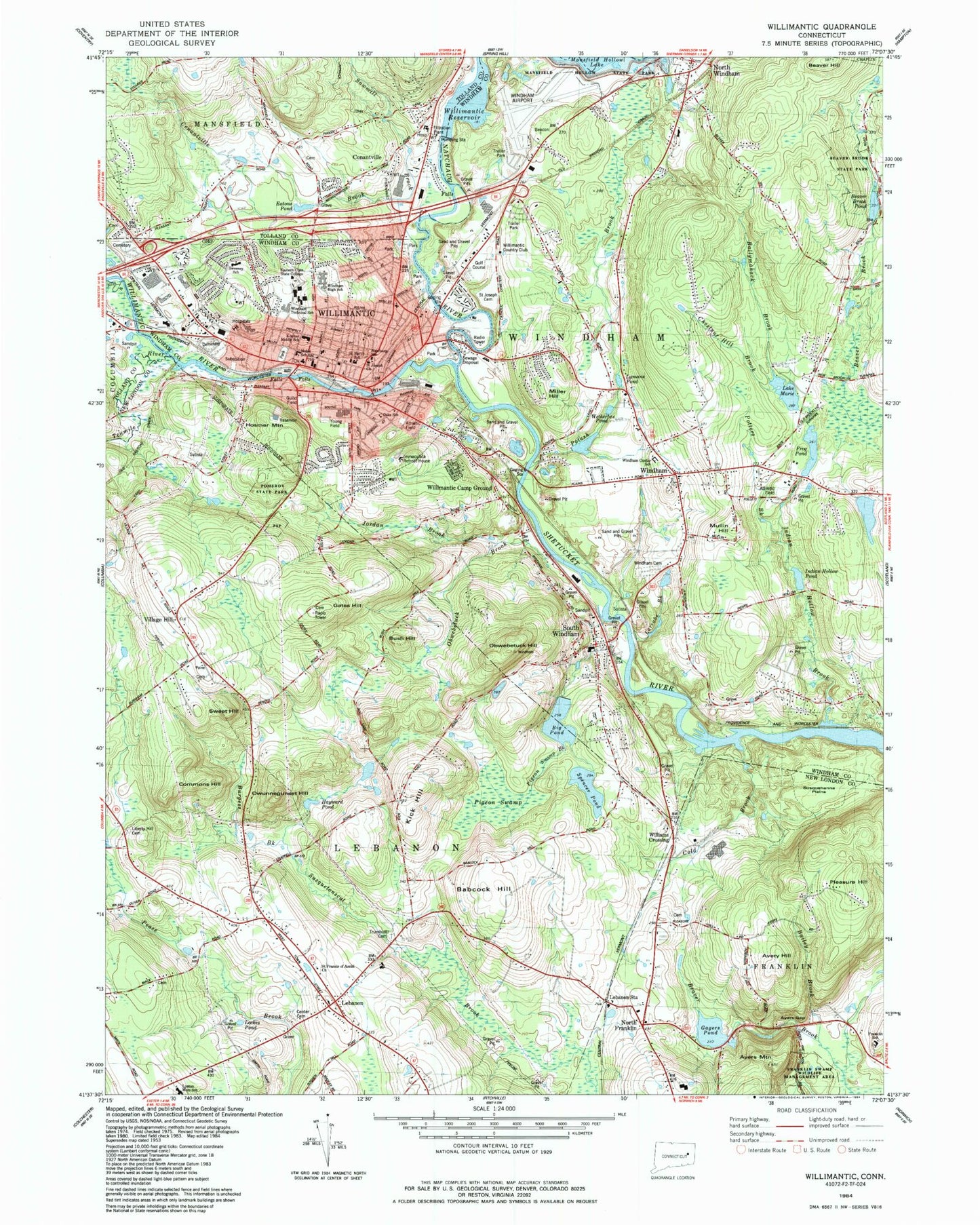
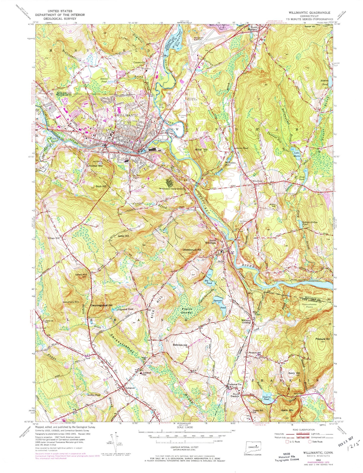
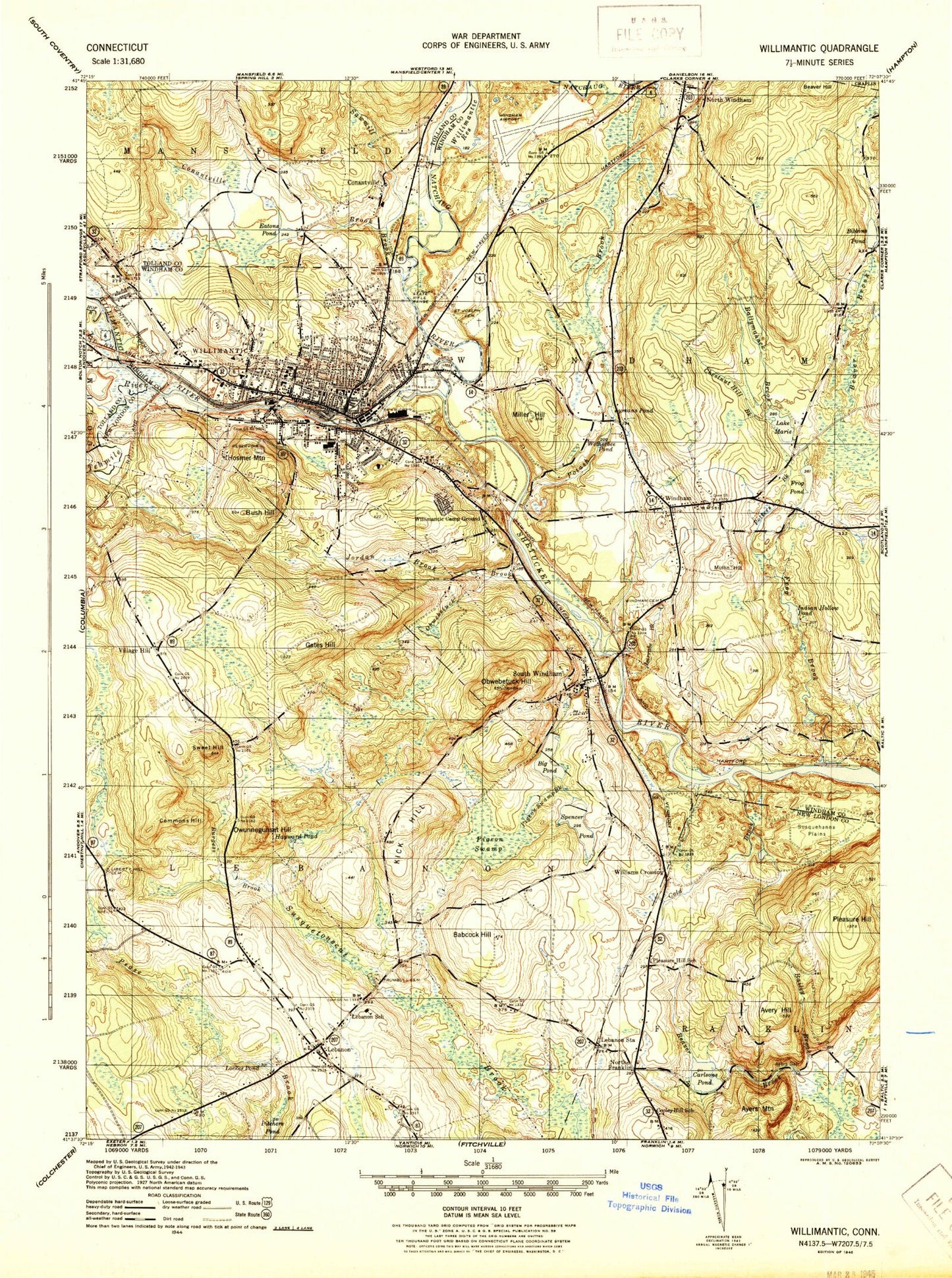
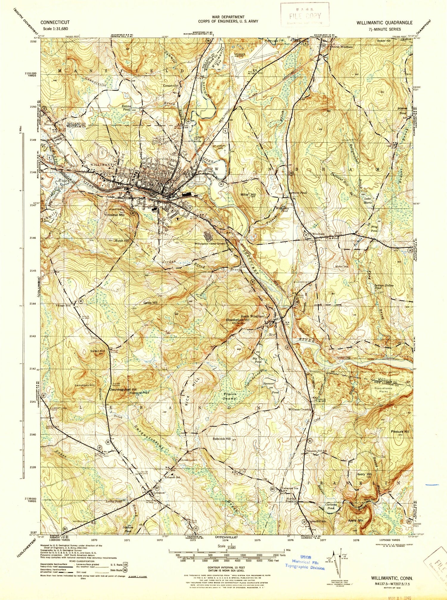
Classic USGS Willimantic Connecticut 7.5'x7.5' Topo Map
Couldn't load pickup availability
Historical USGS topographic quad map of Willimantic in the state of Connecticut. Typical map scale is 1:24,000, but may vary for certain years, if available. Print size: 24" x 27"
This quadrangle is in the following counties: New London, Tolland, Windham.
The map contains contour lines, roads, rivers, towns, and lakes. Printed on high-quality waterproof paper with UV fade-resistant inks, and shipped rolled.
Contains the following named places: Avery Hill, Ayers Gap, Babcock Hill, Bailey Brook, Ballymahack Brook, Beaver Hill, Bibbins Pond, Big Pond, Burgess Brook, Bush Hill, Chestnut Hill Brook, Cold Brook, Commons Hill, Conantville, Conantville Brook, Cooley Hill School, Eatons Pond, Indian Hollow Brook, Frog Pond, Gates Hill, Hayward Pond, Hop River, Hosmer Mountain, Indian Hollow Pond, Jordan Brook, Kick Hill, Larrabe Brook, Lebanon, Lebanon School, Lebanon Station, Liberty Hill Cemetery, Lockes Pond, Lymans Pond, Lake Marie, Miller Hill, Mountain Brook, Mullin Hill, Natchaug River, North Windham, Obwebetuck Brook, Obwebetuck Hill, Owunnegunset Hill, Pigeon Swamp, Pigeon Swamp Brook, Pleasure Hill, Pleasure Hill School, Potash Brook, Pottens Brook, Ridges School, Saint Joseph Cemetery, Sawmill Brook, South Windham, Spencer Pond, Susquehanna Plains, Sweet Hill, Tenmile River, Trumbull Cemetery, Village Hill, Wetherbee Pond, Willimantic, Willimantic Camp Ground, Willimantic Reservoir, Windham, Windham Cemetery, North Franklin, Williams Crossing, Willimantic River, Gagers Pond, Willimantic Country Club, Windham Airport, Nasin Heliport, Windham Hospital Heliport, WILI-AM (Willimantic), WILI-FM (Willimantic), WECS-FM (Willimantic), Town of Lebanon, Town of Windham, Potash Pond Dam, Potash Pond, Big Pond Dam, Frog Pond Dam, Bibbens Pond Dam, Spencer Pond, Willimantic Reservoir Dam, Mansure Pond Dam, Gagers Pond Dam, Spencer Pond Dam, Beaver Brook Pond Dam, Beaver Brook Pond, Indian Hollow Pond Dam, Abundant Life Community Church, Bridge Street Plaza Shopping Center, Burdick Park, Calvary Baptist Church, Camp Horizons, Christian Life Assembly Church, Crotch of the River, Dunham Hall Library, East Brook Mall Shopping Center, First Baptist Church, First Church of Christ Scientist, First Congregational Church, Grant Medical Library, Guild Field, Guilford Smith Memorial Library, Holy Trinity Orthodox Church, Jillison House Museum, Johnson Park, Kramer Middle School, Latvian Evangelical Lutheran Church, Lautor Park, Light on the Hill Christian Church, Main Street Historic District, Memorial Park, Natchaug Hospital, Natchaug School, Noble School, North Windham Elementary School, North Windham Shopping Center, Oblate Fathers Church, Saint Joseph Church, Saint Joseph Convent, Saint Pauls Episcopal Church, Salvation Army, South Ridge Park, South Windham Congregational Church, South Windham Post Office, W B Sweeney School, Windham Community Memorial Hospital, Willimantic Footbridge, Willimantic Post Office, Williamantic Town Hall, Windham Area Interfaith Church, Windham Center Congregational Church, Windham Center Elementary School, Windham Free Library Association, Windham Green, Windham Heights Shopping Center, Windham High School, Windham Post Office, Windham Technical School, Windham Textile and History Museum, Young Field, Church of the Nazarene Church, Ebenezer Lutheran Church, First Society of Spiritualists Church, J Eugene Smith Library, Saint Marys Church, Saint Marys Ukranian Catholic Church, Stanley Chapel African Methodist Episcopal Church, Willimantic Plaza Shopping Center, Willimantic Public Library, Windham Middle School, Eastern Connecticut State University, Beaumont House, Cooley Hill, First Baptist Church, First Congregational Church, Franklin Elementary School, Franklin Volunteer Fire Department, Jonathan Trumbull House, Jonathan Trumbull Library, Lebanon Green Historic District, Lebanon Elementary School, Lebanon Middle School, Lebanon Post Office, Lebanon Town Common, Lebanon Town Hall, Lyman Memorial High School, North Franklin Post Office, Pomeroy State Park, Redeemer Lutheran Church, Tinsdale Hill, Trumbull Park, South Windham Census Designated Place, Willimantic Census Designated Place, Lebanon Fire Department Station 6, Willimantic Fire Department, Windham Center Fire Department, North Windham Volunteer Fire Department, John Trumbull Birthplace, South Windham Fire Department, Willimantic Police Department, Old Willimantic Cemetery, Avery Hill, Ayers Gap, Babcock Hill, Bailey Brook, Ballymahack Brook, Beaver Hill, Bibbins Pond, Big Pond, Burgess Brook, Bush Hill, Chestnut Hill Brook, Cold Brook, Commons Hill, Conantville, Conantville Brook, Cooley Hill School, Eatons Pond, Indian Hollow Brook, Frog Pond, Gates Hill, Hayward Pond, Hop River, Hosmer Mountain, Indian Hollow Pond, Jordan Brook, Kick Hill, Larrabe Brook, Lebanon, Lebanon School, Lebanon Station, Liberty Hill Cemetery, Lockes Pond, Lymans Pond, Lake Marie, Miller Hill, Mountain Brook, Mullin Hill, Natchaug River, North Windham, Obwebetuck Brook, Obwebetuck Hill, Owunnegunset Hill, Pigeon Swamp, Pigeon Swamp Brook, Pleasure Hill, Pleasure Hill School, Potash Brook, Pottens Brook, Ridges School, Saint Joseph Cemetery, Sawmill Brook, South Windham