MyTopo
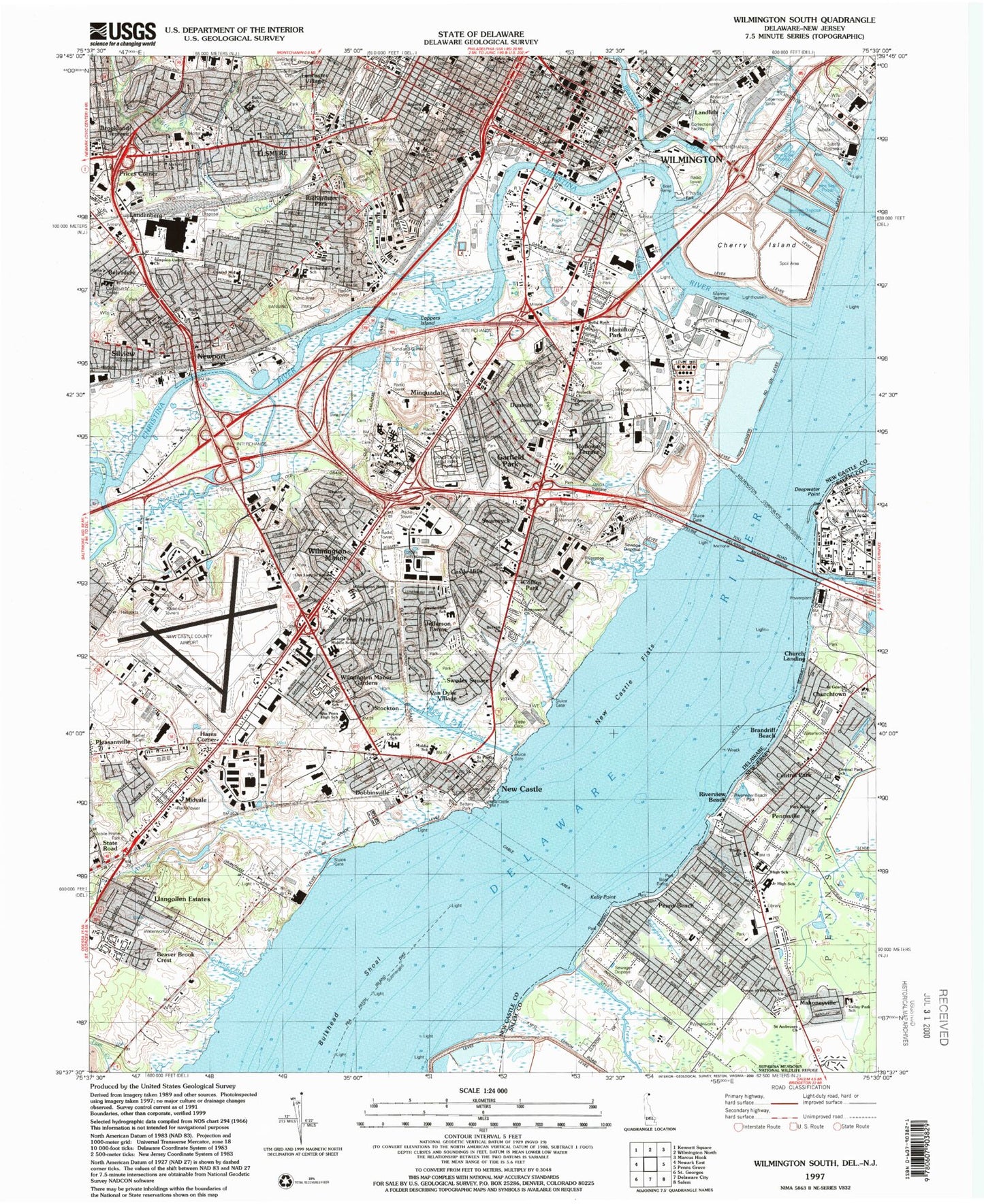
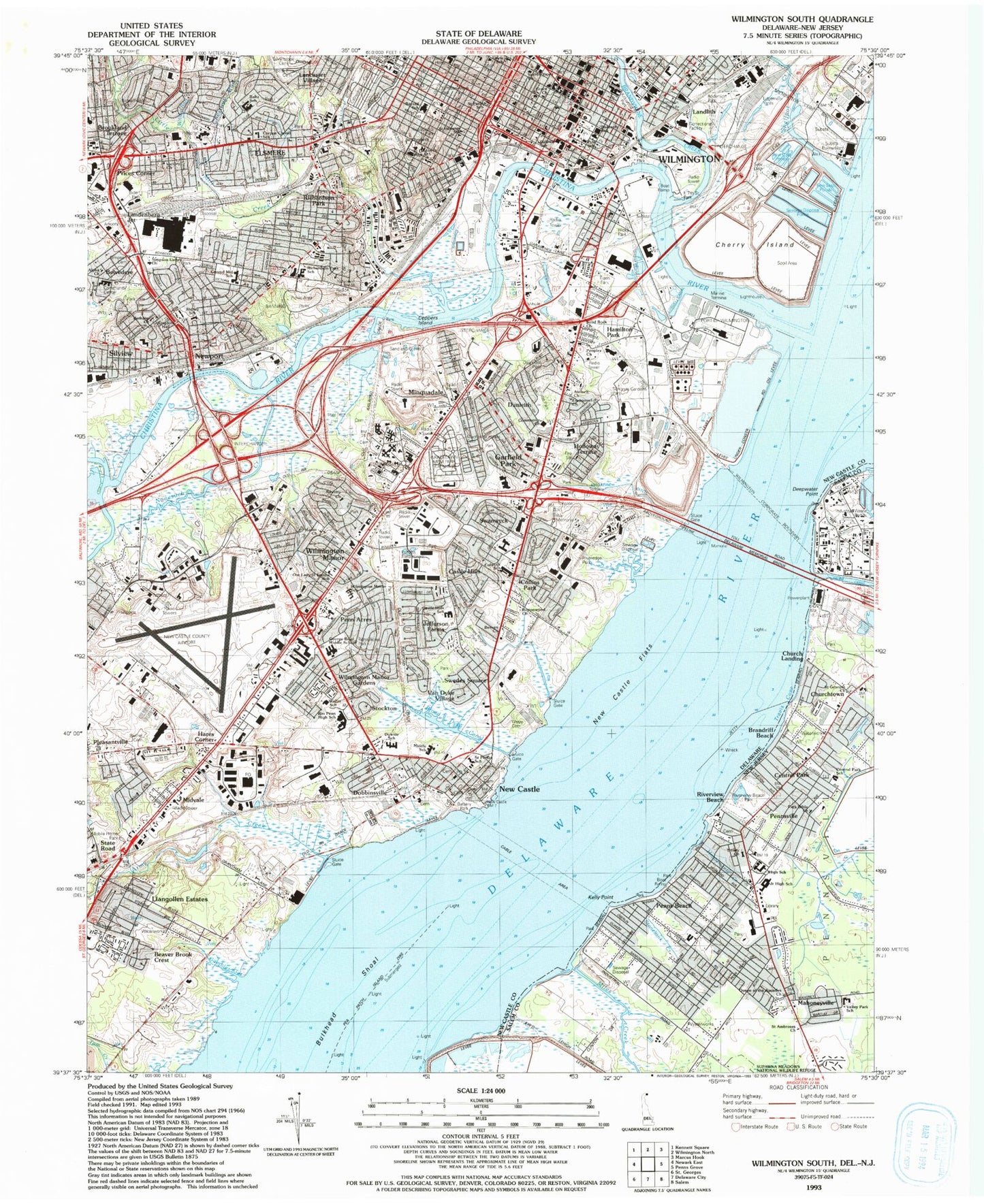
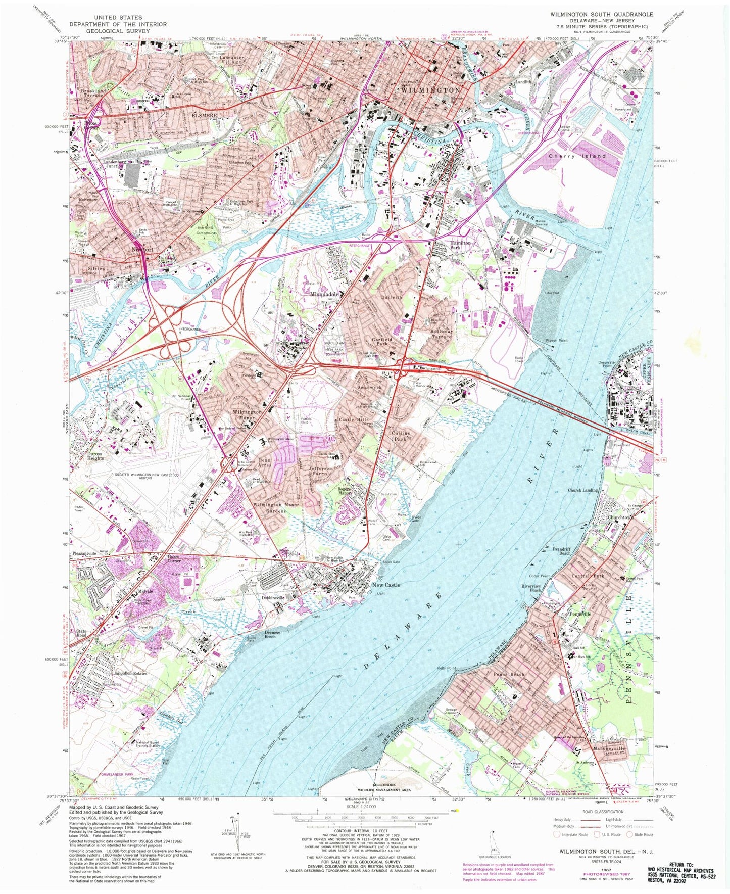
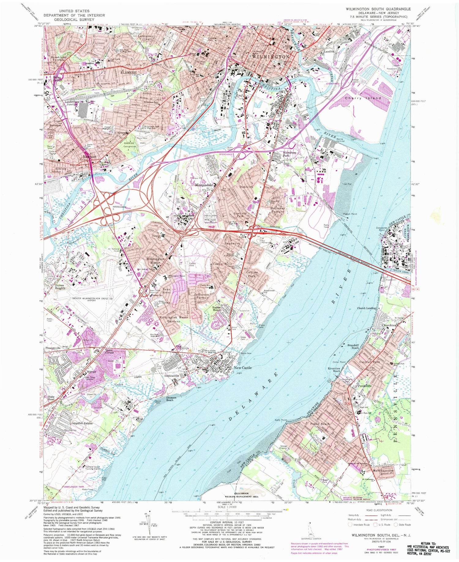
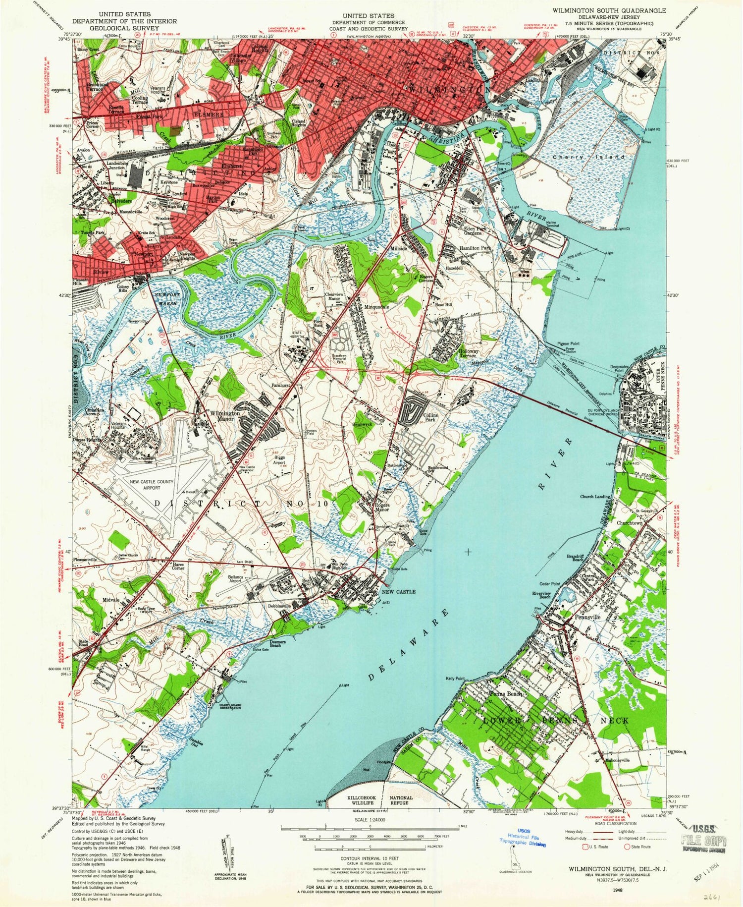
Classic USGS Wilmington South Delaware 7.5'x7.5' Topo Map
Couldn't load pickup availability
Historical USGS topographic quad map of Wilmington South in the states of Delaware, New Jersey. Map scale may vary for some years, but is generally around 1:24,000. Print size is approximately 24" x 27"
This quadrangle is in the following counties: New Castle, Salem.
The map contains contour lines, roads, rivers, towns, and lakes. Printed on high-quality waterproof paper with UV fade-resistant inks, and shipped rolled.
Contains the following named places: 326 Plaza Shopping Center, Airport Industrial Park, Airport Shopping Center, Alban Park, Army Creek, Ashley, Ashley Heights, Avalon, Banning Park, Basin Corner, Basing Road Industrial Park, Battery Park, Bayview Manor, Beaver Brook Shopping Center, Belmoor, Belvidere, Bestfield, Beth Emeth Memorial Park, Biden Park, Boxwood, Boxwood Industrial Park, Brandriff Beach, Brandywine Creek, Broad Dyke Canal, Brookland Terrace, Brown Park, Buttonwood, Canby Park, Canby Park Estates, Canby Park Shopping Center, Castle Hills, Castlewood Industrial Park, Cathedral Cemetery, Cedar Heights, Cedar Point, Central Park, Champlin Village, Chelsea Estates, Cherry Island, Cherry Island Marsh, Cherry Island Range, Chestnut Run, Chestnut Run Shopping Center, Christiana Acres, Christina Park, Christina River, Church Landing, Churchtown, City of New Castle, City of Wilmington, City of Wilmington Filter Water Pollution Control Facility, Claridge Court, Clayton Park, Clearfield, Clearview Manor, Cleland Heights, Collins Park, Colonial Heights, Colony Hills, Compton Park, Connectiv Delmarva Generation, Coopers Island, Crane Hook, Deemers Beach, Deepwater Point, Deepwater Point Range, Deepwater Station Heliport, Delamore Park, Delaware Junction, Dobbinsville, Dunleith, Duross Heights, Dutch Neck, East Minquadale, Eden Park, Eden Park Gardens, Edge Moor-Hay Road Power Plant, Edgemoor Yard, Elliots Addition, Elmhurst, Elsmere, Farnhurst, Fern Hook, Fern Hook Marsh, Forest Brook Glen, Forest Park, Fort Christina Park, Fredericks Addition, Gambles Gut, Garfield Park, Germany Industrial Park, Glebe Cemetery, Gordy Estates, Gracelawn Memorial Park, Hamburg, Hamilton Park, Hares Corner, Hayden Park, Hazeldell, Holloway Terrace, Hoppemense Creek, Idela, James Court Industrial Park, Jefferson Farms, Kelly Point, Keystone, Kirkwood Park, Lamore Industrial Park, Lancaster Village, Landenberg Junction, Landers Park, Landlith, Latimer Estates, Leedon Estates, Liberty, Little Mill Creek, Llangollen Estates, Llangollen Estates Park, Lobdell Canal, Lower Christiana Division, Lyndalia, Lynford, Magazine Ditch, Mahoneyville, Manor Park, Masonicville, Mayview Manor, Middleboro Crest, Middleboro East, Middleboro Manor, Midvale, Miles Creek, Millside, Minquadale, Minquadale Trailer Village, Mount Salem United Methodist Church Cemetery, New Castle, New Castle Airport, New Castle Army Air Field, New Castle Division, New Castle Flats, New Castle Historic District, New Castle Hundred, New Castle Industrial Park, New Castle Reservoir, Newport, Newport Heights, Newport Industrial Park, Newport Marsh, Nonesuch Creek, Oakmont, Old Town Hall, Ommelander Park, Overview Gardens, Parkway Industrial Park, Parkway Plaza Shopping Center, Pea Patch Island Dike, Penn Acres, Penn Acres South, Penn Central Station, Penn Mart Shopping Center, Penns Beach, Pennsville, Pennsville Census Designated Place, Pennsville Shopping Center, Pigeon Point, Pleasant Hills, Potters Field Cemetery, Prices Corner, Prices Corner Center, Rambleton Acres, Richardson Park, Riveredge Park, Riverview Beach, Rodney Square, Rogers Corners, Rogers Manor, Rose Hill Gardens, Rosegate, Roselle Terrace, Saienni Farms, Saint James Cemetery, Scarborough Park, Shellpot Creek, Silverbrook Gardens, Silview, Simonds Gardens, Simpson Cemetery, South Wilmington, Southgate Industrial Park, State Road, Stockton, Stonebank Creek, Stony Crest, Swanwyck, Swanwyck Estates, Swanwyck Gardens, The Dyke, The Green, The Rocks, Town of Elsmere, Town of Newport, Township of Pennsville, Travis Cove, Triangle Mall, Tuxedo Park, Uniqema Wastewater Treatment Facility, Washington Park, WDSP Radio Tower, West Minquadale, West Yard, Westview, White Clay Creek, WIBR Radio Tower, Willow Run, WILM-AM (Wilmington), Wilmington, Wilmington Division, Wilmington Hundred, Wilmington Industrial Park, Wilmington Manor, Wilmington Manor Census Designated Place, Wilmington Manor Gardens, Wilmington Marine Terminal, Wilmington Wastewater Treatment Plant, Wilsmere Yards, WJBR-AM (Wilmington), Wood Wards Addition, Woodcrest, Woodland, Woodland Park, ZIP Codes: 19720, 19801, 19804, 19805